File:Geological map of the southeast San Juan Basin.png
ナビゲーションに移動
検索に移動

このプレビューのサイズ: 800 × 397 ピクセル。 その他の解像度: 320 × 159 ピクセル | 640 × 317 ピクセル | 1,024 × 508 ピクセル | 1,280 × 634 ピクセル | 3,250 × 1,611 ピクセル。
元のファイル (3,250 × 1,611 ピクセル、ファイルサイズ: 1.09メガバイト、MIME タイプ: image/png)
キャプション
キャプション
このファイルの内容を1行で記述してください
概要
[編集]
| 解説 |
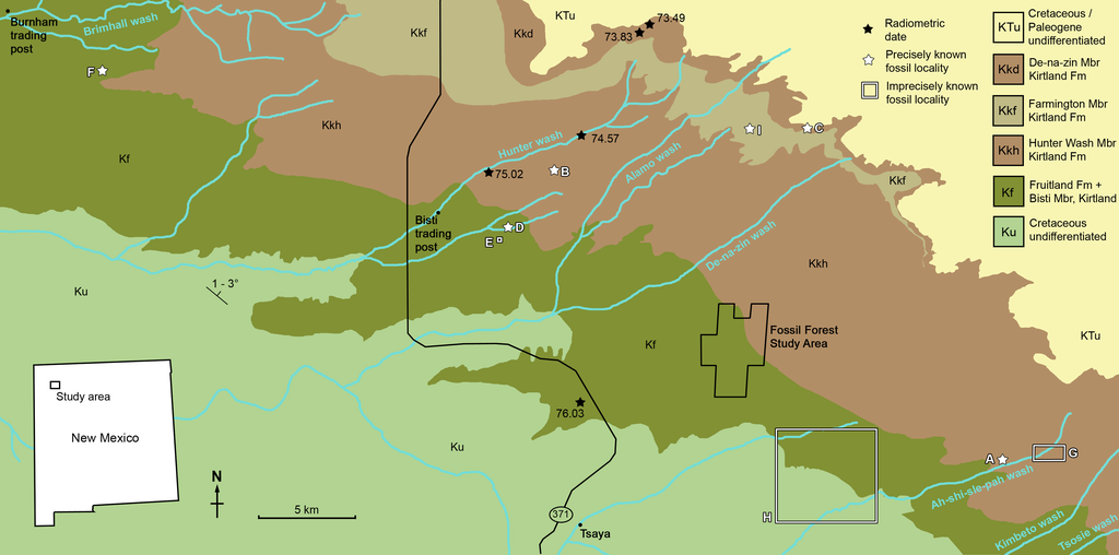
Geological map of the southeast San Juan Basin showing localities of radiometric dates and important fossil specimens mentioned in the text. Collection localities; (A) SMP VP-1500, Navajoceratops sullivani, holotype; (B) NMMNH P-27486, Terminocavus sealeyi, holotype; (C) NMMNH P-33906, Denazin chasmosaurine; (D) NMMNH P-37880, c.f. Pentaceratops sternbergii, parietal fragment; (E) UKVP 16100, c.f. P. sternbergii, complete skull; (F) MNA Pl.1747, c.f. P. sternbergii, complete skull; (G) USNM 8604, Chasmosaurinae sp. anterior end of a parietal median bar; (H) purported collection area of AMNH 6325, P. sternbergii, holotype. (I) NMMNH P-50000, Chasmosaurinae sp. (now Bisticeratops), skull missing frill. Radiometric dates recalibrated from Fassett & Steiner (1997) by Fowler (2017). Bedrock geology altered from O’Sullivan & Beikman (1963). |
| 日付 | |
| 原典 | https://peerj.com/articles/9251/ |
| 作者 | Denver W. Fowler, Elizabeth A. Freedman Fowler |
ライセンス
[編集]
このファイルはクリエイティブ・コモンズ 表示 4.0 国際ライセンスのもとに利用を許諾されています。
- あなたは以下の条件に従う場合に限り、自由に
- 共有 – 本作品を複製、頒布、展示、実演できます。
- 再構成 – 二次的著作物を作成できます。
- あなたの従うべき条件は以下の通りです。
- 表示 – あなたは適切なクレジットを表示し、ライセンスへのリンクを提供し、変更があったらその旨を示さなければなりません。これらは合理的であればどのような方法で行っても構いませんが、許諾者があなたやあなたの利用行為を支持していると示唆するような方法は除きます。
ファイルの履歴
過去の版のファイルを表示するには、その版の日時をクリックしてください。
| 日付と時刻 | サムネイル | 寸法 | 利用者 | コメント | |
|---|---|---|---|---|---|
| 現在の版 | 2020年6月5日 (金) 17:57 | | 3,250 × 1,611 (1.09メガバイト) | FunkMonk (トーク | 投稿記録) | {{Information |description=Geological map of the southeast San Juan Basin showing localities of radiometric dates and important fossil specimens mentioned in the text. Collection localities; (A) SMP VP-1500, Navajoceratops sullivani, holotype; (B) NMMNH P-27486, Terminocavus sealeyi, holotype; (C) NMMNH P-33906, Denazin chasmosaurine; (D) NMMNH P-37880, c.f. Pentaceratops sternbergii, parietal fragment; (E) UKVP 16100, c.f. P. sternbergii, complete skull; (F) MNA Pl.1747, c.f. P. sternbergii,... |
このファイルは上書きできません。
ファイルの使用状況
このファイルを使用しているページはありません。
グローバルなファイル使用状況
以下に挙げる他のウィキがこの画像を使っています:
- en.wikipedia.org での使用状況
- es.wikipedia.org での使用状況
- fr.wikipedia.org での使用状況
- ja.wikipedia.org での使用状況
- nl.wikipedia.org での使用状況
- pt.wikipedia.org での使用状況
- ru.wikipedia.org での使用状況
- zh.wikipedia.org での使用状況
メタデータ
カテゴリ:
- Terminocavus
- Navajoceratops
- Pentaceratops
- San Juan Basin
- Maps relevant to paleontology
- De-na-zin Member, Kirtland Formation
- Farmington Member, Kirtland Formation
- Geological maps of New Mexico
- Hunter Wash Member, Kirtland Formation
- Bisti Member, Kirtland Formation
- Fruitland Formation
- Cretaceous rocks in New Mexico
- Paleogene rocks in New Mexico
- Fossil localities
- Bisticeratops