File:Geologische Übersicht - Ardennen.png
Jump to navigation
Jump to search

Size of this preview: 747 × 600 pixels. Other resolutions: 299 × 240 pixels | 598 × 480 pixels | 957 × 768 pixels | 1,276 × 1,024 pixels | 1,694 × 1,360 pixels.
Original file (1,694 × 1,360 pixels, file size: 333 KB, MIME type: image/png)
Captions
Captions
Add a one-line explanation of what this file represents
Summary
[edit]
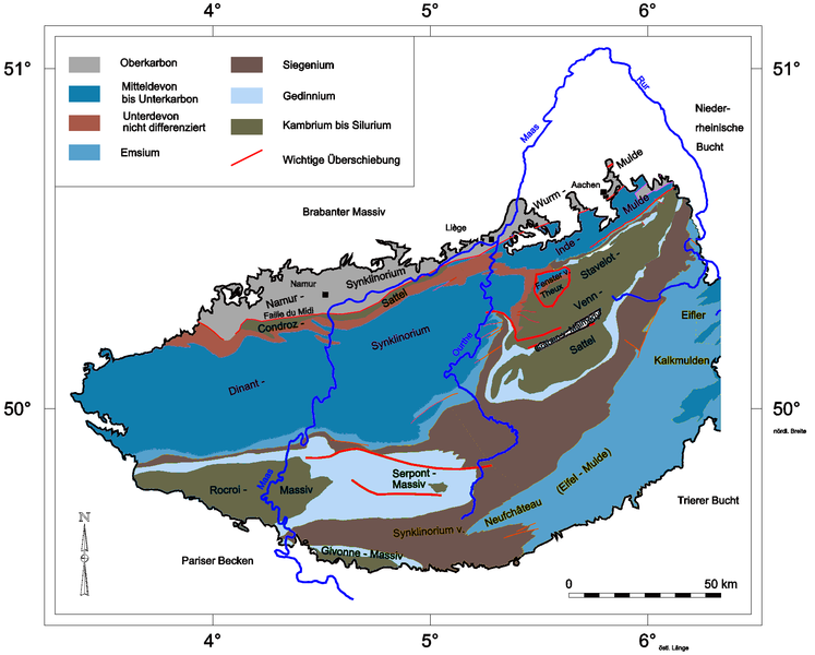
| Description | Geologische Karte der Ardennen mit Benennung der Großstrukturen nach Walter 1992. |
| Date |
2007-12-31 |
| Source | selbst gezeichnet nach eigener Zusammenstellung verschiedener geologischer Karten, Farben angepasst an die Vorgaben der Stratigraphischen Tabelle Deutschland |
| Author | (Jo Weber) |
| Permission (Reusing this file) |
GFDL-self and CC-BY-SA-3.0,2.5,2.0,1.0 (see below) |
Literatur
[edit]
- Walter, R. et al.: Geologie von Mitteleuropa. 5. Auflage, Schweizerbarth’sche Verlagsbuchhandlung, Stuttgart 1992. ISBN 3-510-65149-9
Licensing
[edit]
I, the copyright holder of this work, hereby publish it under the following licenses:

|
Permission is granted to copy, distribute and/or modify this document under the terms of the GNU Free Documentation License, Version 1.2 or any later version published by the Free Software Foundation; with no Invariant Sections, no Front-Cover Texts, and no Back-Cover Texts. A copy of the license is included in the section entitled GNU Free Documentation License. |
This file is licensed under the Creative Commons Attribution-Share Alike 3.0 Unported, 2.5 Generic, 2.0 Generic and 1.0 Generic license.
- You are free:
- to share – to copy, distribute and transmit the work
- to remix – to adapt the work
- Under the following conditions:
- attribution – You must give appropriate credit, provide a link to the license, and indicate if changes were made. You may do so in any reasonable manner, but not in any way that suggests the licensor endorses you or your use.
- share alike – If you remix, transform, or build upon the material, you must distribute your contributions under the same or compatible license as the original.
You may select the license of your choice.
File history
Click on a date/time to view the file as it appeared at that time.
| Date/Time | Thumbnail | Dimensions | User | Comment | |
|---|---|---|---|---|---|
| current | 14:27, 19 January 2008 | | 1,694 × 1,360 (333 KB) | Jo Weber (talk | contribs) | {{Information |Description=Geologische Karte der Ardennen mit Benennung der Großstrukturen nach Walter 1992. |Source=selbst gezeichnet nach eigener Zusammenstellung verschiedener geologischer Karten, Farben angepasst an die Vorgaben der Stratigraphische |
| 14:11, 31 December 2007 |  | 1,688 × 1,360 (365 KB) | Jo Weber (talk | contribs) | {{Information |Description=Geologische Karte der Ardennen mit Benennung der Großstrukturen nach Walter 1992. |Source=selbst gezeichnet nach eigener Zusammenstellung verschiedener geologischer Karten |Date=2007-12-31 |Author=(Jo Weber) |
You cannot overwrite this file.
File usage on Commons
The following page uses this file:
File usage on other wikis
The following other wikis use this file: