File:GermanAustriaMap.png
跳转到导航
跳转到搜索

本预览的尺寸:800 × 579像素。 其他分辨率:320 × 232像素 | 640 × 463像素 | 1,024 × 741像素 | 1,280 × 926像素 | 1,520 × 1,100像素。
原始文件 (1,520 × 1,100像素,文件大小:285 KB,MIME类型:image/png)
说明
说明
添加一行文字以描述该文件所表现的内容
摘要
[编辑]
| 描述 | |
| 日期 | |
| 来源 |
本文件衍生自: Deutschösterreich.PNG |
| 作者 | Postmann Michael, AjaxSmack |

|
This map has been uploaded by Electionworld from en.wikipedia.org to enable the |
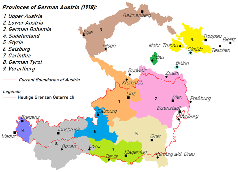
Areas 3 and 4 are transposed: Sudetenland is the area shown West and Silesia in the East
许可协议
[编辑]
| 本作品已被作者AjaxSmack释出到公有领域。这适用于全世界。 在一些国家这可能不合法;如果是这样的话,那么: |
文件历史
点击某个日期/时间查看对应时刻的文件。
| 日期/时间 | 缩略图 | 大小 | 用户 | 备注 | |
|---|---|---|---|---|---|
| 当前 | 2021年7月16日 (五) 20:05 | | 1,520 × 1,100(285 KB) | Kontrollstellekundl(留言 | 贡献) | brighter colours, better resolution |
| 2018年7月28日 (六) 02:15 |  | 788 × 560(27 KB) | AjaxSmack(留言 | 贡献) | Reverted to version as of 07:16, 16 June 2017 (UTC); note text at de:Datei:Deutschösterreich.PNG | |
| 2017年12月24日 (日) 20:42 |  | 788 × 560(27 KB) | Mélomène(留言 | 贡献) | Colors | |
| 2017年6月16日 (五) 07:16 |  | 788 × 560(27 KB) | Valdemar(留言 | 贡献) | Reichenberg is really cs:Liberec | |
| 2014年2月17日 (一) 21:43 |  | 788 × 560(23 KB) | Kirk979(留言 | 贡献) | correction | |
| 2014年2月17日 (一) 21:23 |  | 788 × 560(20 KB) | Kirk979(留言 | 贡献) | correction | |
| 2011年12月29日 (四) 15:50 |  | 788 × 560(31 KB) | Fext(留言 | 贡献) | Fixed location of Reichenberg (Liberec) | |
| 2006年12月23日 (六) 22:49 |  | 788 × 560(23 KB) | Electionworld(留言 | 贡献) | {{ew|en|AjaxSmack}} == Summary == Based on: de:Bild:Deutschösterreich.PNG == Licensing == {{PD-user|AjaxSmack}} |
您不可以覆盖此文件。
文件用途
以下10个页面使用本文件:
- Atlas of Austria
- Atlas of the Czech Republic
- User:J budissin/Uploads/BiH/2017 December 21-31
- User:J budissin/Uploads/BiH/2017 June 11-20
- User:J budissin/Uploads/BiH/2018 July 21-31
- User:Magog the Ogre/Maps of conflicts/2017 December
- User:Magog the Ogre/Maps of conflicts/2017 June
- User:Magog the Ogre/Maps of conflicts/2018 July
- User:Magog the Ogre/Maps of conflicts/2021 July
- Category:Deutschösterreich
全域文件用途
以下其他wiki使用此文件:
- ar.wikipedia.org上的用途
- ast.wikipedia.org上的用途
- azb.wikipedia.org上的用途
- az.wikipedia.org上的用途
- ba.wikipedia.org上的用途
- be-tarask.wikipedia.org上的用途
- be.wikipedia.org上的用途
- ca.wikipedia.org上的用途
- cs.wikipedia.org上的用途
- da.wikipedia.org上的用途
- el.wikipedia.org上的用途
- en.wikipedia.org上的用途
- et.wikipedia.org上的用途
- fa.wikipedia.org上的用途
- fi.wikipedia.org上的用途
- fr.wikipedia.org上的用途
- hu.wikipedia.org上的用途
- hy.wikipedia.org上的用途
- it.wikipedia.org上的用途
- ka.wikipedia.org上的用途
- ko.wikipedia.org上的用途
- lt.wikipedia.org上的用途
- lv.wikipedia.org上的用途
- mk.wikipedia.org上的用途
查看此文件的更多全域用途。