File:Germany, German Democratic Republic location map October 1949 - July 1952.svg

Originaldatei (SVG-Datei, Basisgröße: 1.075 × 1.273 Pixel, Dateigröße: 453 KB)
Bildtexte
Kurzbeschreibungen
Beschreibung
[Bearbeiten]| Beschreibung |
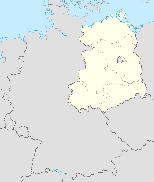
Deutsch: Positionskarte der DDR. Diese Karte zeigt die DDR im Gebietsstand zwischen Oktober 1949 bis Juli 1952.
Quadratische Plattkarte, N-S-Streckung 150 %. Geographische Begrenzung der Karte:
English: Location map of German Democratic Republic. Map shows German Democratic Republic as of October 1949 till July 1952.
Equirectangular projection, N/S stretching 150 %. Geographic limits of the map:
|
||
| Datum | Created in 2009 | ||
| Quelle | own work, based on File:Germany location map.svg | ||
| Urheber | TUBS | ||
| Genehmigung (Weiternutzung dieser Datei) |
Ich, der Urheberrechtsinhaber dieses Werkes, veröffentliche es hiermit unter der folgenden Lizenz:
Diese Datei ist unter der Creative-Commons-Lizenz „Namensnennung – Weitergabe unter gleichen Bedingungen 3.0 nicht portiert“ lizenziert.
Du darfst es unter einer der obigen Lizenzen deiner Wahl verwenden. |
||
| Andere Versionen |
Bundesrepublik Deutschland (vor 1990 nur West-Deutschland):
Deutsche Demokratische Republik (mit BRD im Ausschnitt):
Ostdeutschland (vor 1990 Deutsche Demokratische Republik):
Deutschland zwischen Mai 1945 und Oktober 1949:
Thematisch:
Deutsches Reich (1918–1945) (best used with this template (de)):
|


_23_May_1949_-_6_Oct_1949.svg)


_location_map.svg)
_location_map_2013.svg)


Dateiversionen
Klicke auf einen Zeitpunkt, um diese Version zu laden.
| Version vom | Vorschaubild | Maße | Benutzer | Kommentar | |
|---|---|---|---|---|---|
| aktuell | 03:28, 18. Jan. 2009 | | 1.075 × 1.273 (453 KB) | TUBS (Diskussion | Beiträge) | {{Information |Description=Germany,_Federal_Republic_of__location_map_April_1952_-_August_1955 |Source=own work |Date=2009 |Author=Author:TUBS |Permission= |other_versions= }} <!--{{ImageUpload|basic}}--> |
Du kannst diese Datei nicht überschreiben.
Dateiverwendung
Die folgenden 57 Seiten verwenden diese Datei:
- File:Deutschland Autobahnen.svg
- File:East-West-Germany-October 1949-July 1952.svg
- File:East Germany location map.svg
- File:Germany, Federal Republic of location map 23 May 1949 - 6 Oct 1949.svg
- File:Germany, Federal Republic of location map April 1952 - August 1955.svg
- File:Germany, Federal Republic of location map December 1950 - April 1952.svg
- File:Germany, Federal Republic of location map January 1957 - October 1990.svg
- File:Germany, Federal Republic of location map October 1949 - November 1950.svg
- File:Germany, Federal Republic of location map September 1955 - December 1956.svg
- File:Germany, German Democratic Republic location map January 1957 - October 1990.svg
- File:Germany, German Democratic Republic location map July 1952 - January 1957.svg
- File:Germany, German Democratic Republic location map October 1949 - July 1952.svg
- File:Germany, German Democratic Republic location map w·o FRG July 1952 - October 1990.svg
- File:Germany, German Democratic Republic location map w·o FRG October 1949 - June 1952.svg
- File:Germany, German Demorcratic Republic location map October 1949 - July 1952.svg (Dateiweiterleitung)
- File:Germany location map.svg
- File:Germany, Federal Republic of location map April 1952 - August 1955.svg
- File:Germany, Federal Republic of location map January 1957 - October 1990.svg
- File:Germany, German Democratic Republic location map October 1949 - July 1952.svg
- File:Germany, German Democratic Republic location map January 1957 - October 1990.svg
- File:Germany, German Democratic Republic location map July 1952 - January 1957.svg
- File:Germany location map October 1990 - March 1992.svg
- File:Germany location map April 1992 - July 1992.svg
- File:Germany location map August 1992 - June 1993.svg
- File:Germany, Federal Republic of location map October 1949 - November 1950.svg
- File:Germany, Federal Republic of location map December 1950 - April 1952.svg
- File:Germany, Federal Republic of location map September 1955 - December 1956.svg
- File:Germany2 location map.svg
- File:East Germany location map.svg
- File:Germany location map July 1993 - December 2009.svg
- Template:Germany location map/other versions
- File:Germany location map 23 April 1949 - 22 May 1949.svg
- File:Germany, Federal Republic of location map 23 May 1949 - 6 Oct 1949.svg
- File:Germany, location map (SBZ perspective) 23 May 1949 - 6 Oct 1949.svg
- File:Germany location map 8 Jun 1947 - 22 Apr 1949.svg
- File:Germany location map labeled 8 Jun 1947 - 22 Apr 1949.svg
- File:Germany, German Democratic Republic location map w·o FRG July 1952 - October 1990.svg
- File:Germany, German Democratic Republic location map w·o FRG October 1949 - June 1952.svg
- File:Lage Freiberg in Deutschland.png
- File:Relief Map of Germany.png
- File:East-West-Germany-October 1949-July 1952.svg
- File:Deutschland Autobahnen.svg
- File:Relief Map of Germany.svg
- File:Germany, location map (SBZ perspective) 23 May 1949 - 6 Oct 1949.svg
- File:Germany2 location map.svg
- File:Germany location map.svg
- File:Germany location map 23 April 1949 - 22 May 1949.svg
- File:Germany location map 8 Jun 1947 - 22 Apr 1949.svg
- File:Germany location map April 1992 - July 1992.svg
- File:Germany location map August 1992 - June 1993.svg
- File:Germany location map July 1993 - December 2009.svg
- File:Germany location map October 1990 - March 1992.svg
- File:Germany location map labeled 8 Jun 1947 - 22 Apr 1949.svg
- File:Lage Freiberg in Deutschland.png
- File:Relief Map of Germany.png
- File:Relief Map of Germany.svg
- Template:Germany location map/other versions
Globale Dateiverwendung
Die nachfolgenden anderen Wikis verwenden diese Datei:
- Verwendung auf de.wikipedia.org
- Verwendung auf en.wikipedia.org
- Verwendung auf ja.wikipedia.org
- Verwendung auf pt.wikipedia.org
- Verwendung auf ru.wikipedia.org