File:Germany (2), Neuwerk, Scharhörn, Nigehörn.jpg
跳至導覽
跳至搜尋
預覽大小:691 × 600 像素。 其他解析度:277 × 240 像素 | 553 × 480 像素 | 885 × 768 像素 | 1,180 × 1,024 像素 | 1,941 × 1,684 像素。
原始檔案 (1,941 × 1,684 像素,檔案大小:550 KB,MIME 類型:image/jpeg)
說明
說明
添加單行說明來描述出檔案所代表的內容
摘要
[編輯],_Neuwerk,_Scharh%C3%B6rn,_Nigeh%C3%B6rn.jpg&action=edit§ion=1)
| 描述 |
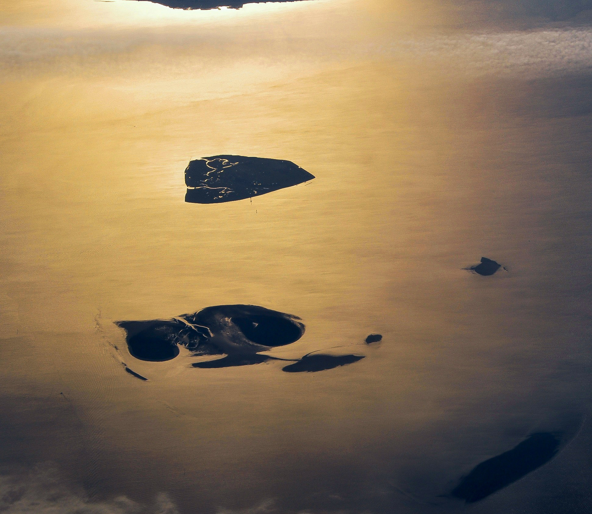
English: Aerial picture of the Hamburg Wadden Sea National Park (German: Nationalpark Hamburgisches Wattenmeer). This park is an exclave of the city state of Hamburg and lies 12.5 km off Cuxhaven in the estuary of the Elbe in the North Sea. The park includes the islands of Neuwerk (above), Scharhörn and Nigehörn (below, appearing as a single island in this picture taken at low tide). The two other islands (right and below right) are parts of the Scharhörn and Neuwerk mudflats (Scharhörner und Neuwerker Watt). Viewing direction is toward the SE.
Nederlands: Luchtfoto van het Hamburgse Nationale Park Waddenzee (Duits: Nationalpark Hamburgisches Wattenmeer). Dit park is een exclave van de stadstaat Hamburg en ligt 12.5 ten NW van Cuxhaven in de monding van de Elbe in de Noordzee. Het park omvat de eilanden Neuwerk (boven), Scharhörn en Nigehörn (die op de foto op één eiland lijken). De twee andere eilanden (rechts en rechts onder) zijn delen van het Scharhörnse en Neuwerkse Wad (Scharhörner und Neuwerker Watt). Blikrichting is naar het zuidoosten. |
| 日期 | |
| 來源 | 自己的作品 |
| 作者 | Vincent van Zeijst |
| 授權許可 (重用此檔案) |
此檔案採用共享創意 姓名標示-相同方式分享 3.0 未在地化版本授權條款。
|
| 拍攝地點 | | 位於此地的本圖片與其他圖片: OpenStreetMap |
|---|
,_Neuwerk,_Scharh%C3%B6rn,_Nigeh%C3%B6rn.jpg¶ms=053.998083_N_0008.338622_E_globe:Earth_type:camera_region:DE_heading:135.00&language=zh-mo)
| 註解 | 該圖片含有註解:在維基媒體共享資源上查看註解 |
,_Neuwerk,_Scharh%C3%B6rn,_Nigeh%C3%B6rn.jpg)
檔案歷史
點選日期/時間以檢視該時間的檔案版本。
| 日期/時間 | 縮圖 | 尺寸 | 用戶 | 備註 | |
|---|---|---|---|---|---|
| 目前 | 2017年12月27日 (三) 13:59 | | 1,941 × 1,684(550 KB) | Aeroid(對話 | 貢獻) | dust removal |
| 2011年3月26日 (六) 16:59 |  | 1,941 × 1,684(543 KB) | Loranchet(對話 | 貢獻) | {{Information |Description ={{en|1=Aerial picture of the Hamburg Wadden Sea National Park (German: Nationalpark Hamburgisches Wattenmeer). This park is an exclave of the city state of Hamburg and lies 12.5 km off Cuxhaven in the estuary of the Elbe in |
無法覆蓋此檔案。
檔案用途
全域檔案使用狀況
以下其他 wiki 使用了這個檔案:
- az.wikipedia.org 的使用狀況
- ban.wikipedia.org 的使用狀況
- de.wikipedia.org 的使用狀況
- en.wikipedia.org 的使用狀況
- fa.wikipedia.org 的使用狀況
- hsb.wikipedia.org 的使用狀況
- mk.wikipedia.org 的使用狀況
- nl.wikipedia.org 的使用狀況
- pl.wikipedia.org 的使用狀況
- sv.wikipedia.org 的使用狀況
- tr.wikipedia.org 的使用狀況
- ur.wikipedia.org 的使用狀況
- vi.wikipedia.org 的使用狀況
- zh.wikipedia.org 的使用狀況
,_Neuwerk,_Scharhörn,_Nigehörn.jpg&oldid=529733504)