File:GhEngelLangenegg1.JPG
Jump to navigation
Jump to search

Size of this preview: 644 × 600 pixels. Other resolutions: 258 × 240 pixels | 515 × 480 pixels | 825 × 768 pixels | 1,099 × 1,024 pixels | 1,898 × 1,768 pixels.
Original file (1,898 × 1,768 pixels, file size: 1.22 MB, MIME type: image/jpeg)
Captions
Captions
Add a one-line explanation of what this file represents
| Description |
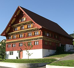
Deutsch: aus dem DEHIO Vorarlberg 1983: Ehem. Gasthof Engel (Oberlangenegg Nr. 9), im Kirchdorf nördl. der Pfarrkirche. Einhof mit steilem Satteldach, im Typus des Rheintalhauses, lt. Inschr. erb. 1778. Stirnseite über gemauertem Sockelgeschoss 5achsig, 2geschossig und 2geschossiger Giebel. Schinedelpanzer, Klebdächer mit tiefen Gesimskehlen, diese wie die Unterseiten des Dachvorstosses ornamental, figural und mit Sprüchen bemalt, bez. 1778; gekuppelte Fenster mit geschnitzten Mittelpfosten. Im Inneren zwei Gaststuben, bmkw. Stiegengeländer, Malerei bez. 1778. in Langenegg,Vorarlberg. Das Haus steht unter Denkmalschutz.
|
| Date | |
| Source | Own work |
| Author | böhringer friedrich |
| Permission (Reusing this file) |
I, the copyright holder of this work, hereby publish it under the following license: This file is licensed under the Creative Commons Attribution-Share Alike 2.5 Generic license.
|
| Other versions |
|

This Photo was taken by Böhringer Friedrich.
|
Feel free to use my photos, but please mention me as the author and if you want send me a message. or (rufre@lenz-nenning.at) |
| Camera location | | View this and other nearby images on: OpenStreetMap |
|---|
| Object location | | View this and other nearby images on: OpenStreetMap |
|---|
Quelle: Dehio Vorarlberg
File history
Click on a date/time to view the file as it appeared at that time.
| Date/Time | Thumbnail | Dimensions | User | Comment | |
|---|---|---|---|---|---|
| current | 20:47, 9 November 2007 | | 1,898 × 1,768 (1.22 MB) | Böhringer (talk | contribs) | {{Information |Description= {{de| Ehem. Gasthof Engel (Oberlangenegg Nr. 9), im Kirchdorf nördl. der Pfarrkirche. Einhof mit steilem Satteldach, im Typus des Rheintalhauses, lt. Inschr. erb. 1778. Stirnseite über gemauertem Sockelgeschoss 5achsig, 2gesc |
You cannot overwrite this file.
File usage on Commons
The following 4 pages use this file:
File usage on other wikis
The following other wikis use this file:
- Usage on de.wikipedia.org
- Usage on www.wikidata.org