File:Glasgow park access network (8520851663).png

Original file (1,073 × 632 pixels, file size: 160 KB, MIME type: image/png)
Captions
Captions
Summary
[edit].png&action=edit§ion=1)
| Description |
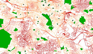
Map showing distance from parks in Glasgow. Dark red equals further away from park. Distance is calculated from park entrances indicated by black points. This is a rough hack to demonstrate the possibilities of openstreetmap data and GRASS/qgis network analysis. This was inspired by this GRASS tutorial: <a href="http://jcastellssala.wordpress.com/2012/05/07/basic-network-analysis-with-grass/" rel="noreferrer nofollow">jcastellssala.wordpress.com/2012/05/07/basic-network-anal...</a> I used QGIS's GRASS gui and shell. Park entrance points were produced by making the park polygons into line vectors and then intersecting with highway network (including footpaths etc). I used QGIS vector analysis and geometry tools to achieve this. Next project will look at pubs... All data copyright OpenStreetMap contributors under ODbL. <a href="http://www.openstreetmap.com" rel="noreferrer nofollow">www.openstreetmap.com</a> |
| Date | |
| Source | Glasgow park access network |
| Author | macrofight using OSM data |
Licensing
[edit].png&action=edit§ion=2)
- You are free:
- to share – to copy, distribute and transmit the work
- to remix – to adapt the work
- Under the following conditions:
- attribution – You must give appropriate credit, provide a link to the license, and indicate if changes were made. You may do so in any reasonable manner, but not in any way that suggests the licensor endorses you or your use.
- share alike – If you remix, transform, or build upon the material, you must distribute your contributions under the same or compatible license as the original.
| This image was originally posted to Flickr by macrofight at https://flickr.com/photos/29266908@N02/8520851663. It was reviewed on 21 November 2022 by FlickreviewR 2 and was confirmed to be licensed under the terms of the cc-by-sa-2.0. |
File history
Click on a date/time to view the file as it appeared at that time.
| Date/Time | Thumbnail | Dimensions | User | Comment | |
|---|---|---|---|---|---|
| current | 18:59, 21 November 2022 | | 1,073 × 632 (160 KB) | Mateusz Konieczny (talk | contribs) | Transferred from Flickr via #flickr2commons |
You cannot overwrite this file.
File usage on Commons
There are no pages that use this file.
.png&oldid=889634150)