File:Gniewoszów (gmina) location map.png
Jump to navigation
Jump to search

Size of this preview: 513 × 600 pixels. Other resolutions: 205 × 240 pixels | 411 × 480 pixels | 645 × 754 pixels.
Original file (645 × 754 pixels, file size: 97 KB, MIME type: image/png)
Captions
Captions
Add a one-line explanation of what this file represents
| Description |
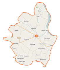
Polski: Mapa gminy Gniewoszów, Polska
English: Map of Gmina Gniewoszów, Poland |
|||||||||
| Date | ||||||||||
| Source | You may find a page on the OpenStreetMap wiki page for Gniewoszów (gmina) | |||||||||
| Creator |
OpenStreetMap contributors OpenStreetMap contributors |
|||||||||
| Permission (Reusing this file) |
OpenStreetMap data is available under the Open Database License (details). Map tiles are licensed under the Creative Commons Attribution-ShareAlike 2.0 license (CC-BY-SA 2.0).
This file is licensed under the Creative Commons Attribution-Share Alike 2.0 Generic license.
|
|||||||||
| Geotemporal data | ||||||||||
| Bounding box |
|
|||||||||
| Georeferencing | If inappropriate please set warp_status = skip to hide. | |||||||||
File history
Click on a date/time to view the file as it appeared at that time.
| Date/Time | Thumbnail | Dimensions | User | Comment | |
|---|---|---|---|---|---|
| current | 10:23, 12 September 2014 | | 645 × 754 (97 KB) | VanWiel (talk | contribs) | |
| 13:31, 28 July 2014 |  | 645 × 754 (133 KB) | VanWiel (talk | contribs) | {{OpenStreetMap | name = Gniewoszów (gmina) | location = Gniewoszów (gmina) | description = {{pl|Mapa gminy Gniewoszów, Polska}} {{en|Map of Gmina Gniewoszów, Poland}} | top = 51.5406 | left =... |
You cannot overwrite this file.
File usage on Commons
There are no pages that use this file.
File usage on other wikis
The following other wikis use this file:
- Usage on be.wikipedia.org
- Usage on pl.wikipedia.org
- Gniewoszów (gmina)
- Kociołek (województwo mazowieckie)
- Markowola
- Markowola-Kolonia
- Oleksów
- Regów Stary
- Sławczyn
- Wólka Bachańska
- Wysokie Koło
- Zdunków
- Boguszówka (województwo mazowieckie)
- Gniewoszów (województwo mazowieckie)
- Mieścisko (województwo mazowieckie)
- Borek (powiat kozienicki)
- Sarnów (powiat kozienicki)
- Zalesie (powiat kozienicki)
- Zwola (powiat kozienicki)
- Marianów (gmina Gniewoszów)
- Podmieście (gmina Gniewoszów)
- Granica (Gniewoszów)
- Regów Nowy
- Parafia Niepokalanego Serca Maryi w Gniewoszowie
- Cmentarz żydowski w Gniewoszowie-Granicy
- Cmentarz żydowski w Gniewoszowie
- Stawki (gmina Gniewoszów)
- Cmentarz wojenny w Wysokim Kole
- Sarnów k. Wysokiego Koła
- Wysokie Koło (stacja kolejowa)
- Parafia św. Stanisława w Oleksowie
- Parafia Najświętszej Maryi Panny Królowej Różańca Świętego w Wysokim Kole
- Kościół Niepokalanego Serca Maryi w Gniewoszowie
- Moduł:Mapa/dane/Gniewoszów (gmina)
- Kościół Najświętszej Maryi Panny Królowej Różańca Świętego w Wysokim Kole
- Stary Oleksów
- Usage on pl.wikibooks.org
- Usage on tt.wikipedia.org
- Usage on www.wikidata.org
_location_map.png&oldid=519964240)