File:Golan heights rel89-orig.jpg
Spring til navigation
Spring til søgning

Størrelse af denne forhåndsvisning: 474 × 599 pixels. Andre opløsninger: 190 × 240 pixels | 380 × 480 pixels | 974 × 1.231 pixels.
Oprindelig fil (974 × 1.231 billedpunkter, filstørrelse: 245 KB, MIME-type: image/jpeg)
Captions
Captions
Tilføj en kort forklaring på en enkelt linje om hvad filen viser
| Beskrivelse |
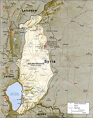
English: CIA map of the Golan Heights showing Israeli settlements and Syrian villages as of 1989 |
|||
| Dato | ||||
| Kilde | http://www.lib.utexas.edu/maps/middle_east_and_asia/golan_heights_rel89.jpg | |||
| Forfatter | CIA | |||
| Tilladelse (Genbrug af denne fil) |
|

Filhistorik
Klik på en dato/tid for at se filen som den så ud på det tidspunkt.
| Dato/tid | Miniaturebillede | Dimensioner | Bruger | Kommentar | |
|---|---|---|---|---|---|
| nuværende | 7. jul. 2009, 15:15 | | 974 × 1.231 (245 KB) | Nableezy (diskussion | bidrag) | {{Information |Description={{en|1=CIA map of the Golan Height showing Israeli settlements and Syrian villages as of 1989}} |Source=http://www.lib.utexas.edu/maps/middle_east_and_asia/golan_heights_rel89.jpg |Author=CIA |Date=1989 |Permission={{PD-USGov-CI |
Du kan ikke overskrive denne fil.
Filanvendelse
Den følgende side bruger denne fil:
Global filanvendelse
Følgende andre wikier anvender denne fil:
- Anvendelser på ar.wikipedia.org
- Anvendelser på arz.wikipedia.org
- Anvendelser på be-tarask.wikipedia.org
- Anvendelser på bg.wikipedia.org
- Anvendelser på ca.wikipedia.org
- Anvendelser på csb.wikipedia.org
- Anvendelser på cs.wikipedia.org
- Anvendelser på da.wikipedia.org
- Anvendelser på en.wikipedia.org
- Anvendelser på es.wikipedia.org
- Anvendelser på fy.wikipedia.org
- Anvendelser på hi.wikipedia.org
- Anvendelser på hy.wikipedia.org
- Anvendelser på id.wikipedia.org
- Anvendelser på incubator.wikimedia.org
- Anvendelser på it.wikipedia.org
- Anvendelser på ka.wikipedia.org
- Anvendelser på lt.wikipedia.org
- Anvendelser på ms.wikipedia.org
- Anvendelser på nl.wikipedia.org
- Anvendelser på nn.wikipedia.org
- Anvendelser på no.wikipedia.org
- Anvendelser på pl.wikipedia.org
- Anvendelser på pnb.wikipedia.org
- Anvendelser på pt.wikibooks.org
- Anvendelser på ru.wikipedia.org
- Anvendelser på uk.wikipedia.org
- Anvendelser på uz.wikipedia.org
- Anvendelser på vi.wikipedia.org
- Anvendelser på www.wikidata.org
- Anvendelser på xmf.wikipedia.org
Vis flere globale anvendelser af denne fil.