File:Granville Street trackbed 26.jpg
Jump to navigation
Jump to search

Size of this preview: 405 × 599 pixels. Other resolutions: 162 × 240 pixels | 325 × 480 pixels | 519 × 768 pixels | 692 × 1,024 pixels | 1,385 × 2,048 pixels | 3,777 × 5,584 pixels.
Original file (3,777 × 5,584 pixels, file size: 12.14 MB, MIME type: image/jpeg)
Captions
Captions
Add a one-line explanation of what this file represents
| Description |
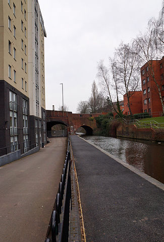
English: Looking north along the trackbed of former Granville Street railway station approach, the original northern terminus of the Birmingham West Suburban Railway in Birmingham, England. To the right is the Worcester and Birmingham Canal. The bridge carries Bath Row road. Behind a bridge behind the camera is Five Ways railway station on the replacement Cross-City Line. Contrast modified in Photoshop. |
| Date | Taken on 12 March 2015 |
| Source | Own work |
| Author | Oosoom at English Wikipedia |
| Permission (Reusing this file) |
I, the copyright holder of this work, hereby publish it under the following license: This file is licensed under the Creative Commons Attribution-Share Alike 3.0 Unported license.
|
| Camera location | | View this and other nearby images on: OpenStreetMap |
|---|
File history
Click on a date/time to view the file as it appeared at that time.
| Date/Time | Thumbnail | Dimensions | User | Comment | |
|---|---|---|---|---|---|
| current | 15:41, 16 March 2015 | | 3,777 × 5,584 (12.14 MB) | Oosoom (talk | contribs) | {{Information |Description={{en|Looking north along the trackbed of former {{w|Granville Street railway station}} approach, the original northern terminus of the {{w|Birmingham West Suburban Railway}} in {{w|Birmingham}}, England. To the right is the {... |
You cannot overwrite this file.
File usage on Commons
The following 2 pages use this file:
File usage on other wikis
The following other wikis use this file:
- Usage on en.wikipedia.org