File:Grattan episode map, 1854. Fort Laramie, stone marker and historic trails.png
Jump to navigation
Jump to search

Size of this preview: 611 × 600 pixels. Other resolutions: 244 × 240 pixels | 489 × 480 pixels | 770 × 756 pixels.
Original file (770 × 756 pixels, file size: 1.4 MB, MIME type: image/png)
Captions
Captions
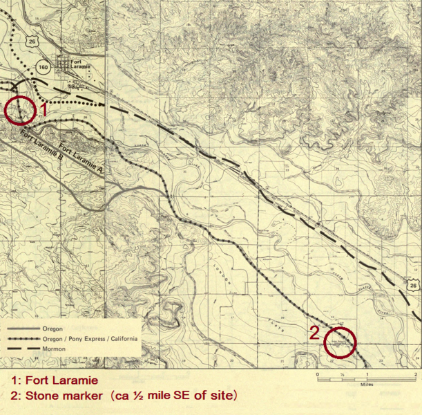
Map relating to the Grattan episode in 1854
Summary[edit]
| Description |
Dansk: Kort tilpasset tekst om Grattan-episoden der viser Fort Laramie, en del af Oregon Trail og placeringen af mindestenen over Grattan-episoden i 1854, opstillet omkring 800 meter sydøst for kamppladsen
English: Map adapted to text about the Grattan episode in 1854. It shows Fort Laramie, part of the Oregon Trail and the location of the stone marker put up half a mile SE of the site of the battle |
| Date | |
| Source |
OREGON/MORMON PIONEER NATIONAL HISTORIC TRAILS MANAGEMENT PLAN. Prepared By: United States Department of the Interior. Bureau of Land Management. May 1986 |
| Author | Prepared By: United States Department of the Interior. Bureau of Land Management. May 1986 |
Licensing[edit]
This work is in the public domain in the United States because it is a work prepared by an officer or employee of the United States Government as part of that person’s official duties under the terms of Title 17, Chapter 1, Section 105 of the US Code.
Note: This only applies to original works of the Federal Government and not to the work of any individual U.S. state, territory, commonwealth, county, municipality, or any other subdivision. This template also does not apply to postage stamp designs published by the United States Postal Service since 1978. (See § 313.6(C)(1) of Compendium of U.S. Copyright Office Practices). It also does not apply to certain US coins; see The US Mint Terms of Use.
|
 | |
| This file has been identified as being free of known restrictions under copyright law, including all related and neighboring rights. | ||

|
This is a file uploaded through the Danish Wikipedia, which has not been reviewed on Commons:
|
File history
Click on a date/time to view the file as it appeared at that time.
| Date/Time | Thumbnail | Dimensions | User | Comment | |
|---|---|---|---|---|---|
| current | 06:42, 29 January 2022 | | 770 × 756 (1.4 MB) | Indianertosset (talk | contribs) | Uploaded a work by Prepared By: United States Department of the Interior. Bureau of Land Management. May 1986 from OREGON/MORMON PIONEER NATIONAL HISTORIC TRAILS MANAGEMENT PLAN. Prepared By: United States Department of the Interior. Bureau of Land Management. May 1986 with UploadWizard |
You cannot overwrite this file.
File usage on Commons
The following page uses this file:
File usage on other wikis
The following other wikis use this file:
- Usage on da.wikipedia.org