File:Great Britain army 512 Field Survey Company, Rafah (FL155882446 4073097).jpg
Jump to navigation
Jump to search

Size of this preview: 800 × 590 pixels. Other resolutions: 320 × 236 pixels | 640 × 472 pixels | 1,024 × 756 pixels | 1,280 × 945 pixels | 2,560 × 1,890 pixels | 18,041 × 13,316 pixels.
Original file (18,041 × 13,316 pixels, file size: 309.83 MB, MIME type: image/jpeg)
Captions
Captions
Add a one-line explanation of what this file represents
Summary
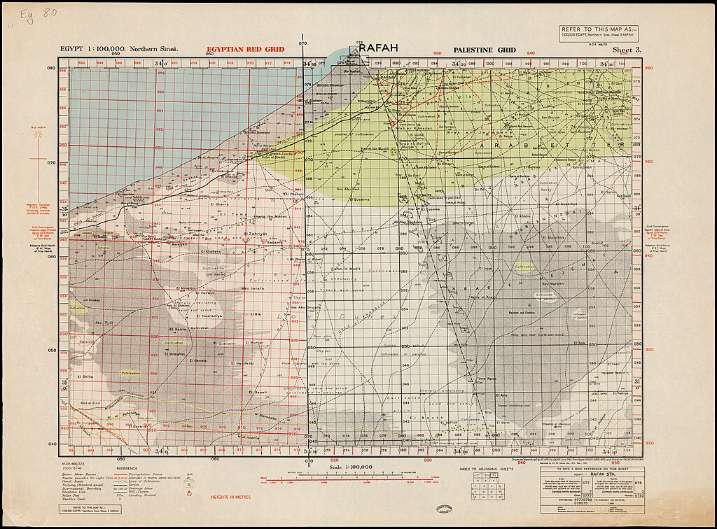
[edit]| Rafah
( |
||||||||||||||||||||||||
|---|---|---|---|---|---|---|---|---|---|---|---|---|---|---|---|---|---|---|---|---|---|---|---|---|
| Artist |
|
|||||||||||||||||||||||
| Title |
Rafah |
|||||||||||||||||||||||
| Publisher |
512 Fd. Survey Coy |
|||||||||||||||||||||||
| Description |
Rafah. Drawn and reproduced by 512 Fd. Svy. Coy. R.E. from a Survey of Egypt map. |
|||||||||||||||||||||||
| Language | English | |||||||||||||||||||||||
| Publication date | from 1942 until 1945 | |||||||||||||||||||||||
| Medium | 1 sheet ; | |||||||||||||||||||||||
| Dimensions | height: 51 cm (20 in); width: 71 cm (27.9 in) | |||||||||||||||||||||||
| Collection |
|
|||||||||||||||||||||||
| Current location |
|
|||||||||||||||||||||||
| Place of publication | unknown | |||||||||||||||||||||||
| search Merhav catalog | unknown | |||||||||||||||||||||||
| Notes |
M.D.R. 466/225.; Drawn... 1942, Reprinted ... 1945.; Shows pillars, police posts, landing grounds, telephon lines, Camal routes etc.; כולל ציון מיקום עמודי גבול. מסלולי נחיתה, שבילי גמלים ועוד. English: Egypt 1:100,000, Northern Sinai ; 3 | |||||||||||||||||||||||
| scale | 1:100,000 cm | |||||||||||||||||||||||
| IE PID | IE155882444 | |||||||||||||||||||||||
| Rosetta filename | FL155882446 | |||||||||||||||||||||||
| NNL item ID (P3959) | 990040730970205171 | |||||||||||||||||||||||
| search Merhav catalog | English, Great Britain army 512 Field Survey Company | |||||||||||||||||||||||
| search Merhav catalog | 512 Fd. Survey Coy | |||||||||||||||||||||||
| Source/Photographer |
|
|||||||||||||||||||||||
| Other versions | ||||||||||||||||||||||||
| Jpg / Tif version |
|
|||||||||||||||||||||||

.jpg)

.jpg&action=edit§ion=1)
Licensing
[edit].jpg&action=edit§ion=2)
This work is in the public domain in the United States because it is a work prepared by an officer or employee of the United States Government as part of that person’s official duties under the terms of Title 17, Chapter 1, Section 105 of the US Code.
Note: This only applies to original works of the Federal Government and not to the work of any individual U.S. state, territory, commonwealth, county, municipality, or any other subdivision. This template also does not apply to postage stamp designs published by the United States Postal Service since 1978. (See § 313.6(C)(1) of Compendium of U.S. Copyright Office Practices). It also does not apply to certain US coins; see The US Mint Terms of Use.
|
 | |
| This file has been identified as being free of known restrictions under copyright law, including all related and neighboring rights. | ||
[[Category:]]
File history
Click on a date/time to view the file as it appeared at that time.
| Date/Time | Thumbnail | Dimensions | User | Comment | |
|---|---|---|---|---|---|
| current | 20:16, 3 September 2023 | | 18,041 × 13,316 (309.83 MB) | Geagea (talk | contribs) | pattypan 22.03 |
You cannot overwrite this file.
File usage on Commons
The following 2 pages use this file:
.jpg&oldid=798225790)