File:Greater Love Fellowship - fmr St. Andrew's Evangelical Church - Buffalo, New York - 20200930.jpg
Jump to navigation
Jump to search

Size of this preview: 800 × 600 pixels. Other resolutions: 320 × 240 pixels | 640 × 480 pixels | 1,024 × 768 pixels | 1,280 × 960 pixels | 2,053 × 1,539 pixels.
Original file (2,053 × 1,539 pixels, file size: 1.05 MB, MIME type: image/jpeg)
Captions
Captions
Add a one-line explanation of what this file represents
Summary
[edit]
| Description |
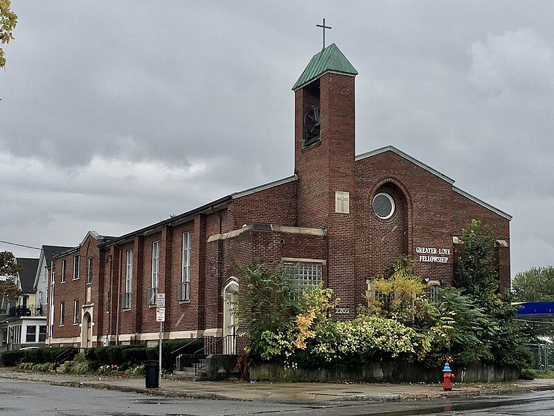
English: Greater Love Fellowship, 2205 Genesee Street at Domedion Avenue, Buffalo, New York, September 2020. The interesting architectural design of the church - Modernist in style, but heavily influenced by Late Gothic Revival - is the work of the firm of Shelgren & Whitman, who adapted an earlier design by Bley & Lyman. Here we see the sleek straight lines and simplified geometrical forms typical of midcentury architecture accentuated by the presence of bluntly pointed arches, which are found crowning the entrances on the east side of the building as well as in the recessed portion of the façade. Noteworthy also is the tower, featuring an open belfry and a hipped roof in copper. The church was built to serve as home of St. Andrew's Evangelical Church, one of the first to be established in the outer portion of the Schiller Park neighborhood of Buffalo, which at that time (1904) was only beginning to change over from open fields to an urban area. Rev. Gottlieb Berner's efforts to evangelize among the small but growing community of German-Americans led to the construction of a small frame chapel, which was planned to be replaced by a larger building. Construction began in 1919 but came to a halt in 1923 due to lack of funding; the congregation continued worshipping in their partly completed church, covered by a temporary roof, for the next quarter-century as the Great Depression and World War II stymied any thought of recommencing construction. The building was finally completed in 1951. St. Andrew's United Church of Christ, as it was ultimately known, dissolved in 2007, following which their former home was purchased by Greater Love Fellowship, a Pentecostal church with a majority-black membership. |
| Date | |
| Source | Own work |
| Author | Andre Carrotflower |
| Camera location | | View this and other nearby images on: OpenStreetMap |
|---|
Licensing
[edit]
I, the copyright holder of this work, hereby publish it under the following license:
This file is licensed under the Creative Commons Attribution-Share Alike 4.0 International license.
- You are free:
- to share – to copy, distribute and transmit the work
- to remix – to adapt the work
- Under the following conditions:
- attribution – You must give appropriate credit, provide a link to the license, and indicate if changes were made. You may do so in any reasonable manner, but not in any way that suggests the licensor endorses you or your use.
- share alike – If you remix, transform, or build upon the material, you must distribute your contributions under the same or compatible license as the original.
File history
Click on a date/time to view the file as it appeared at that time.
| Date/Time | Thumbnail | Dimensions | User | Comment | |
|---|---|---|---|---|---|
| current | 16:24, 14 November 2020 | | 2,053 × 1,539 (1.05 MB) | Andre Carrotflower (talk | contribs) | Uploaded own work with UploadWizard |
You cannot overwrite this file.
File usage on Commons
The following page uses this file:
Metadata
Categories:
- September 2020 in Buffalo
- Churches in the United States photographed in 2020
- Churches in New York (state) built in 1951
- Built in Buffalo, New York in 1951
- 1950s churches in Buffalo, New York
- Brick churches in Buffalo, New York
- Gothic Revival churches in Buffalo, New York
- Modernist churches in Buffalo, New York
- Former United Church of Christ churches in Buffalo, New York
- Genesee Street (Buffalo, New York)
- Schiller Park, Buffalo, New York
- Shelgren & Whitman