File:Greater austria.png
Siirry navigaatioon
Siirry hakuun

Tämän esikatselun koko: 703 × 600 kuvapistettä. Muut resoluutiot: 281 × 240 kuvapistettä | 563 × 480 kuvapistettä | 900 × 768 kuvapistettä | 1 200 × 1 024 kuvapistettä | 1 500 × 1 280 kuvapistettä.
Alkuperäinen tiedosto (1 500 × 1 280 kuvapistettä, 45 KiB, MIME-tyyppi: image/png)
Kuvatekstit
Kuvatekstit
Lisää yhden rivin pituinen kuvaus tästä tiedostosta
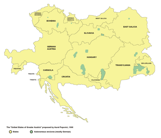
Map of the proposed United States of Greater Austria in 1906
Yhteenveto
[muokkaa]
- English: map of the proposed United States of Greater Austria in 1906
- Serbian: мапа предложених Сједињених Држава Велике Аустрије (1906. године)
Source and licence
[muokkaa]

|
This map has been uploaded by Electionworld from en.wikipedia.org to enable the |
| Tämän teoksen tekijä, PANONIAN, on julkaissut sen public domainiin. Tämä on voimassa maailmanlaajuisesti. Joissain maissa laki ei mahdollista tätä. Mikäli näin on: |
self made map by user:PANONIAN
see de:Bild:Vereinigte Staaten von Groß-Österreich.png for german version. --Rdb 12:12, 2 April 2007 (UTC)
Tiedoston historia
Päiväystä napsauttamalla näet, millainen tiedosto oli kyseisellä hetkellä.
| Päiväys | Pienoiskuva | Koko | Käyttäjä | Kommentti | |
|---|---|---|---|---|---|
| nykyinen | 23. joulukuuta 2006 kello 22.47 | | 1 500 × 1 280 (45 KiB) | Electionworld (keskustelu | muokkaukset) | {{ew|en|PANONIAN}} {{PD-user|PANONIAN}} map of the {{link|United States of Greater Austria}} (self made) |
Et voi tallentaa uutta tiedostoa tämän tilalle.
Tiedoston käyttö
Seuraavat 13 sivua käyttävät tätä tiedostoa:
Tiedoston järjestelmänlaajuinen käyttö
Seuraavat muut wikit käyttävät tätä tiedostoa:
- Käyttö kohteessa be.wikipedia.org
- Käyttö kohteessa cy.wikipedia.org
- Käyttö kohteessa el.wikipedia.org
- Käyttö kohteessa en.wikipedia.org
- Käyttö kohteessa eu.wikipedia.org
- Käyttö kohteessa fi.wikipedia.org
- Käyttö kohteessa fr.wikipedia.org
- Käyttö kohteessa hu.wikipedia.org
- Käyttö kohteessa id.wikipedia.org
- Käyttö kohteessa it.wikipedia.org
- Käyttö kohteessa ja.wikipedia.org
- Käyttö kohteessa ko.wikipedia.org
- Käyttö kohteessa lmo.wikipedia.org
- Käyttö kohteessa pt.wikipedia.org
- Käyttö kohteessa ro.wikipedia.org
- Käyttö kohteessa ru.wikipedia.org
- Käyttö kohteessa sk.wikipedia.org
- Käyttö kohteessa uk.wikipedia.org
- Käyttö kohteessa vi.wikipedia.org
- Käyttö kohteessa zh.wikipedia.org
Luokat:
- Maps of Austria-Hungary
- Maps of the history of Hungary (1850–1918)
- Maps of the Habsburg period in the history of Serbia
- Maps of the history of Vojvodina
- Maps of the history of Croatia (1526–1918)
- Maps of the history of modern Slovenia
- Maps of the history of modern Romania
- Maps of the history of Transylvania
- Maps of the history of Ukraine in the early modern period
- Maps of the history of Slovakia
- Maps of the history of Czechia
- Maps of the history of Poland
- Maps of the history of Italy
- Maps of Greater Austria
- Maps of proposed subdivisions of Austria-Hungary
- Aurel C. Popovici
- Maps of Székely Land
- Ukrainians in Austria-Hungary