File:Greater austria.png
跳至導覽
跳至搜尋

預覽大小:703 × 600 像素。 其他解析度:281 × 240 像素 | 563 × 480 像素 | 900 × 768 像素 | 1,200 × 1,024 像素 | 1,500 × 1,280 像素。
原始檔案 (1,500 × 1,280 像素,檔案大小:45 KB,MIME 類型:image/png)
說明
說明
添加單行說明來描述出檔案所代表的內容
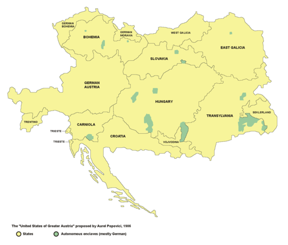
Map of the proposed United States of Greater Austria in 1906
摘要
[編輯]
- English: map of the proposed United States of Greater Austria in 1906
- Serbian: мапа предложених Сједињених Држава Велике Аустрије (1906. године)
Source and licence
[編輯]

|
This map has been uploaded by Electionworld from en.wikipedia.org to enable the |
| 此作品已由其作者,PANONIAN,釋出至公有領域。此授權條款在全世界均適用。 這可能在某些國家不合法,如果是的話: |
self made map by user:PANONIAN
see de:Bild:Vereinigte Staaten von Groß-Österreich.png for german version. --Rdb 12:12, 2 April 2007 (UTC)
檔案歷史
點選日期/時間以檢視該時間的檔案版本。
| 日期/時間 | 縮圖 | 尺寸 | 用戶 | 備註 | |
|---|---|---|---|---|---|
| 目前 | 2006年12月23日 (六) 22:47 | | 1,500 × 1,280(45 KB) | Electionworld(對話 | 貢獻) | {{ew|en|PANONIAN}} {{PD-user|PANONIAN}} map of the {{link|United States of Greater Austria}} (self made) |
無法覆蓋此檔案。
檔案用途
下列13個頁面有用到此檔案:
全域檔案使用狀況
以下其他 wiki 使用了這個檔案:
- be.wikipedia.org 的使用狀況
- cy.wikipedia.org 的使用狀況
- el.wikipedia.org 的使用狀況
- en.wikipedia.org 的使用狀況
- eu.wikipedia.org 的使用狀況
- fi.wikipedia.org 的使用狀況
- fr.wikipedia.org 的使用狀況
- hu.wikipedia.org 的使用狀況
- id.wikipedia.org 的使用狀況
- it.wikipedia.org 的使用狀況
- ja.wikipedia.org 的使用狀況
- ko.wikipedia.org 的使用狀況
- lmo.wikipedia.org 的使用狀況
- pt.wikipedia.org 的使用狀況
- ro.wikipedia.org 的使用狀況
- ru.wikipedia.org 的使用狀況
- sk.wikipedia.org 的使用狀況
- uk.wikipedia.org 的使用狀況
- vi.wikipedia.org 的使用狀況
- zh.wikipedia.org 的使用狀況
分類:
- Maps of Austria-Hungary
- Maps of the history of Hungary (1850–1918)
- Maps of the Habsburg period in the history of Serbia
- Maps of the history of Vojvodina
- Maps of the history of Croatia (1526–1918)
- Maps of the history of modern Slovenia
- Maps of the history of modern Romania
- Maps of the history of Transylvania
- Maps of the history of Ukraine in the early modern period
- Maps of the history of Slovakia
- Maps of the history of Czechia
- Maps of the history of Poland
- Maps of the history of Italy
- Maps of Greater Austria
- Maps of proposed subdivisions of Austria-Hungary
- Aurel C. Popovici
- Maps of Székely Land
- Ukrainians in Austria-Hungary