File:Greenfield Square Marker.JPG
Jump to navigation
Jump to search

Size of this preview: 450 × 600 pixels. Other resolutions: 180 × 240 pixels | 360 × 480 pixels | 576 × 768 pixels | 1,200 × 1,600 pixels.
Original file (1,200 × 1,600 pixels, file size: 442 KB, MIME type: image/jpeg)
Captions
Captions
Add a one-line explanation of what this file represents
|
This is an image of a place or building that is listed on the National Register of Historic Places in the United States of America. Its reference number is 88001908. |
Summary
[edit]
| Description |
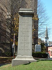
English: The marker in Court House Square, Greenfield, Massachusetts, which points out the directions to the White Mountains, Mohawk Trail, Albany, Boston and New York. |
||||
| Date |
Taken in Autumn 2004
29 March 2008 (original upload date) |
||||
| Source |
Own work (ToddC4176 at en.wikipedia) |
||||
| Author | ToddC4176 at en.wikipedia |
Licensing
[edit]
ToddC4176 at en.wikipedia, the copyright holder of this work, hereby publishes it under the following licenses:
This file is licensed under the Creative Commons Attribution-Share Alike 3.0 Unported license.
Attribution: ToddC4176 at en.wikipedia
- You are free:
- to share – to copy, distribute and transmit the work
- to remix – to adapt the work
- Under the following conditions:
- attribution – You must give appropriate credit, provide a link to the license, and indicate if changes were made. You may do so in any reasonable manner, but not in any way that suggests the licensor endorses you or your use.
- share alike – If you remix, transform, or build upon the material, you must distribute your contributions under the same or compatible license as the original.

|
Permission is granted to copy, distribute and/or modify this document under the terms of the GNU Free Documentation License, Version 1.2 or any later version published by the Free Software Foundation; with no Invariant Sections, no Front-Cover Texts, and no Back-Cover Texts. A copy of the license is included in the section entitled GNU Free Documentation License. |
You may select the license of your choice.
Original upload log
[edit]
The original description page was here. All following user names refer to en.wikipedia.
- 2008-03-29 13:36 ToddC4176 1200×1600× (453034 bytes) {{Information |Description=The marker in Court House Square, Greenfield, Massachusetts, which points out the directions to the White Mountains, Mohawk Trail, Albany, Boston and New York. |Source=self-made |Date=taken Fall, 2004 |Location=Court House Squar
File history
Click on a date/time to view the file as it appeared at that time.
| Date/Time | Thumbnail | Dimensions | User | Comment | |
|---|---|---|---|---|---|
| current | 03:35, 19 February 2011 | | 1,200 × 1,600 (442 KB) | File Upload Bot (Magnus Manske) (talk | contribs) | {{BotMoveToCommons|en.wikipedia|year={{subst:CURRENTYEAR}}|month={{subst:CURRENTMONTHNAME}}|day={{subst:CURRENTDAY}}}} {{Information |Description={{en|The marker in Court House Square, Greenfield, Massachusetts, which points out the directions to the Whi |
You cannot overwrite this file.
File usage on Commons
There are no pages that use this file.
File usage on other wikis
The following other wikis use this file:
- Usage on de.wikipedia.org
- Usage on en.wikipedia.org
- Usage on ja.wikipedia.org