File:Grizzly Mountain aerial.jpg
From Wikimedia Commons, the free media repository
Jump to navigation
Jump to search
![File:Grizzly Mountain aerial.jpg](https://upload.wikimedia.org/wikipedia/commons/thumb/f/f7/Grizzly_Mountain_aerial.jpg/800px-Grizzly_Mountain_aerial.jpg?20210930031949)
Size of this preview: 800 × 483 pixels. Other resolutions: 320 × 193 pixels | 640 × 386 pixels | 1,024 × 618 pixels | 1,280 × 772 pixels | 1,976 × 1,192 pixels.
Original file (1,976 × 1,192 pixels, file size: 813 KB, MIME type: image/jpeg)
File information
Structured data
Captions
Captions
Add a one-line explanation of what this file represents
Summary
[edit]DescriptionGrizzly Mountain aerial.jpg |
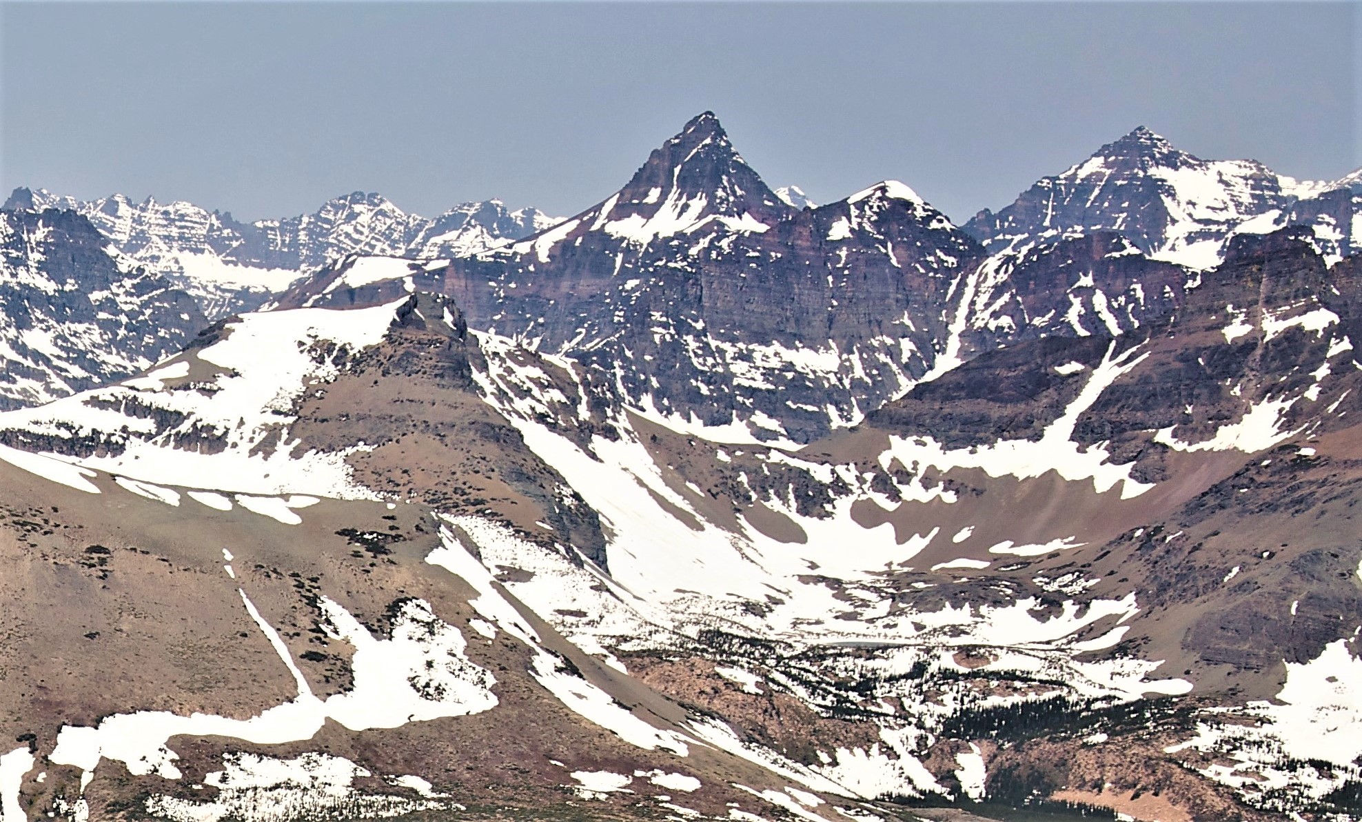
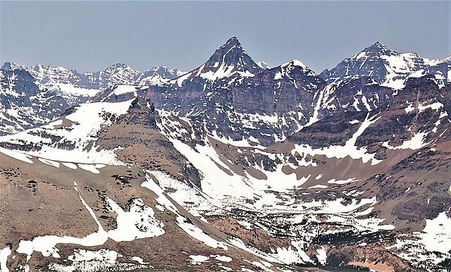
English: Aerial view of Grizzly Mountain (centered), Red Crow Mountain (lower left), and Mount Rockwell (upper right). Camera pointed northwest. Glacier National Park, Montana. |
Date | |
Source | File:Calf Robe Mountain, aerial.jpg |
Author | Sam Beebe |
Camera location | 48° 23′ 02.4″ N, 113° 15′ 32.4″ W ![]() ![]() | View this and other nearby images on: OpenStreetMap | ![]() |
---|
Licensing
[edit]![w:en:Creative Commons](https://upload.wikimedia.org/wikipedia/commons/thumb/7/79/CC_some_rights_reserved.svg/90px-CC_some_rights_reserved.svg.png)
![attribution](https://upload.wikimedia.org/wikipedia/commons/thumb/1/11/Cc-by_new_white.svg/24px-Cc-by_new_white.svg.png)
This file is licensed under the Creative Commons Attribution 2.5 Generic license.
- You are free:
- to share – to copy, distribute and transmit the work
- to remix – to adapt the work
- Under the following conditions:
- attribution – You must give appropriate credit, provide a link to the license, and indicate if changes were made. You may do so in any reasonable manner, but not in any way that suggests the licensor endorses you or your use.
Annotations InfoField | This image is annotated: View the annotations at Commons |
877
155
277
212
1976
1192
Grizzly Mountain
425
412
237
220
1976
1192
Red Crow Mountain
1551
175
217
143
1976
1192
Mount Rockwell
File history
Click on a date/time to view the file as it appeared at that time.
Date/Time | Thumbnail | Dimensions | User | Comment | |
---|---|---|---|---|---|
current | 03:19, 30 September 2021 | ![]() | 1,976 × 1,192 (813 KB) | Ron Clausen (talk | contribs) | Uploaded a work by Sam Beebe from File:Calf Robe Mountain, aerial.jpg with UploadWizard |
You cannot overwrite this file.
File usage on Commons
There are no pages that use this file.
File usage on other wikis
The following other wikis use this file:
- Usage on en.wikipedia.org
Metadata
This file contains additional information such as Exif metadata which may have been added by the digital camera, scanner, or software program used to create or digitize it. If the file has been modified from its original state, some details such as the timestamp may not fully reflect those of the original file. The timestamp is only as accurate as the clock in the camera, and it may be completely wrong.
Camera manufacturer | NIKON CORPORATION |
---|---|
Camera model | NIKON D90 |
Exposure time | 1/1,250 sec (0.0008) |
F-number | f/5.6 |
ISO speed rating | 200 |
Date and time of data generation | 11:12, 4 June 2009 |
Lens focal length | 38 mm |
Latitude | 48° 23′ 2.4″ N |
Longitude | 113° 15′ 32.4″ W |
Altitude | 2,493 meters above sea level |
Copyright holder | Creative Commons Attribution 3.0 |
Author | Samuel M Beebe |
Credit/Provider | Samuel M Beebe, Ecotrust |
Pixel composition | RGB |
Orientation | Normal |
Horizontal resolution | 72 dpi |
Vertical resolution | 72 dpi |
Software used | Windows Photo Editor 10.0.10011.16384 |
File change date and time | 20:10, 29 September 2021 |
Exposure Program | Aperture priority |
Date and time of digitizing | 11:12, 4 June 2009 |
APEX exposure bias | 0 |
Maximum land aperture | 4.3 APEX (f/4.44) |
Metering mode | Pattern |
Light source | Unknown |
Flash | Flash did not fire |
DateTime subseconds | 00 |
DateTimeOriginal subseconds | 00 |
DateTimeDigitized subseconds | 00 |
Color space | sRGB |
Sensing method | One-chip color area sensor |
Custom image processing | Normal process |
Exposure mode | Auto exposure |
White balance | Auto white balance |
Digital zoom ratio | 1 |
Focal length in 35 mm film | 57 mm |
Scene capture type | Standard |
Scene control | None |
Contrast | Normal |
Saturation | Normal |
Sharpness | Normal |
Subject distance range | Unknown |
GPS time (atomic clock) | 17:12 |
Satellites used for measurement | 08 |
Reference for direction of image | Magnetic direction |
Direction of image | 359.1 |
GPS tag version | 2.2.0.0 |
IIM version | 2 |
Contact information | www.ecotrust.org |
Country shown | United States |
Province or state shown | Montana |
Keywords |
|
Code for country shown | US |