File:Grube Münden bei Nentershausen.jpg
![File:Grube Münden bei Nentershausen.jpg](https://upload.wikimedia.org/wikipedia/commons/thumb/5/5d/Grube_M%C3%BCnden_bei_Nentershausen.jpg/800px-Grube_M%C3%BCnden_bei_Nentershausen.jpg?20210930200802)
Original file (6,048 × 4,032 pixels, file size: 8.3 MB, MIME type: image/jpeg)
Captions
Captions
Summary
[edit]DescriptionGrube Münden bei Nentershausen.jpg |
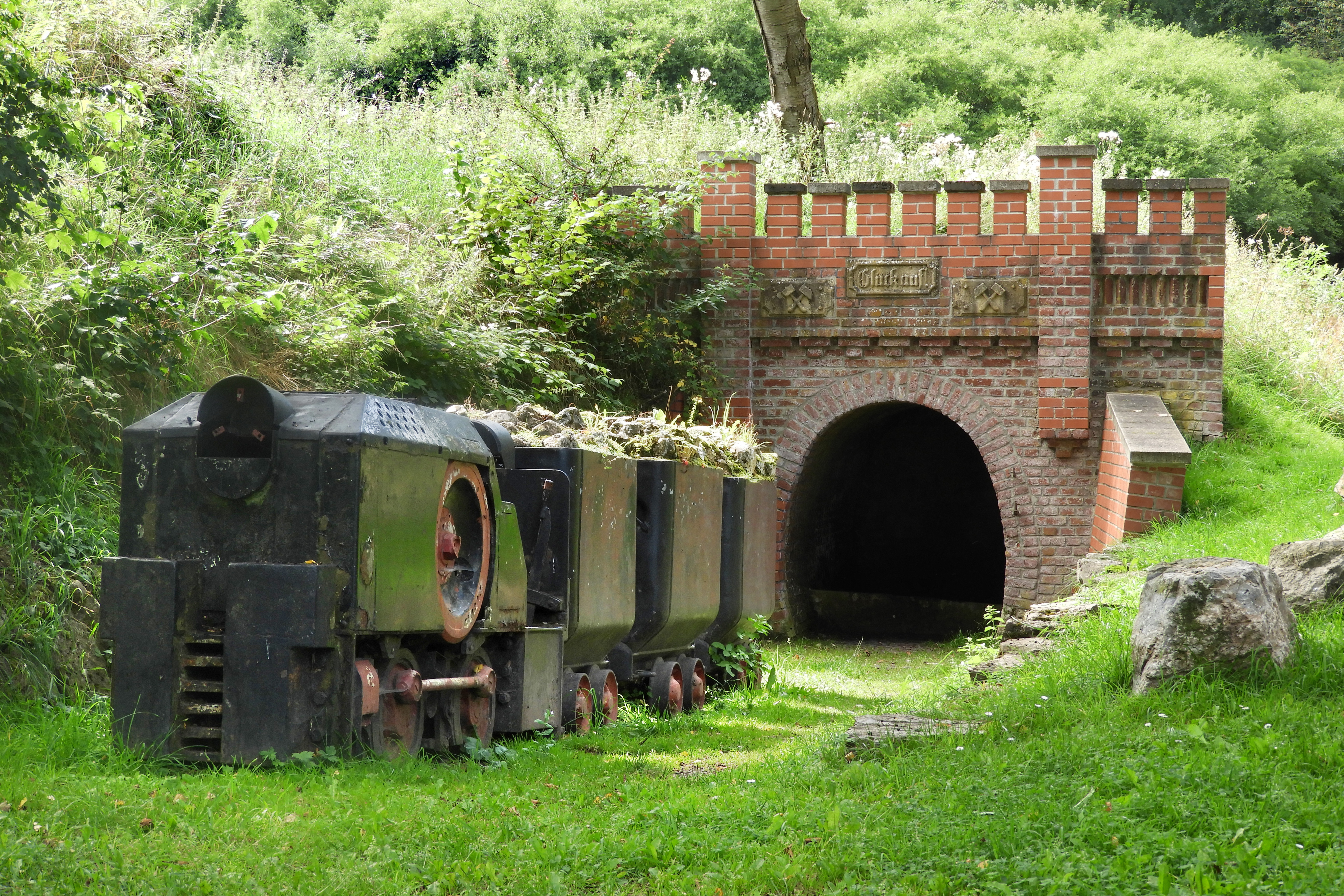
Deutsch: Die Grube Münden bei Nentershausen im Landkreis Hersfeld-Rotenburg war ein Schwerspatbergwerk im Richelsdorfer Gebirge. Betrieben wurde sie ab der zweiten Hälfte des 19. Jahrhunderts, zunächst im Tagebau und seit 1873 untertage. Ihre Blütezeit lag in der Zeit vor dem Ersten Weltkrieg sowie in den Jahren von 1928 bis 1939. Die Grube Münden war der ergiebigste Standort in der Region.
|
||
Date | |||
Source | Own work | ||
Author | Heinz K. S. |
Camera location | 51° 00′ 52.54″ N, 9° 55′ 26.66″ E ![]() | View this and other nearby images on: OpenStreetMap | ![]() |
---|
Licensing
[edit]![w:en:Creative Commons](https://upload.wikimedia.org/wikipedia/commons/thumb/7/79/CC_some_rights_reserved.svg/90px-CC_some_rights_reserved.svg.png)
![attribution](https://upload.wikimedia.org/wikipedia/commons/thumb/1/11/Cc-by_new_white.svg/24px-Cc-by_new_white.svg.png)
![share alike](https://upload.wikimedia.org/wikipedia/commons/thumb/d/df/Cc-sa_white.svg/24px-Cc-sa_white.svg.png)
- You are free:
- to share – to copy, distribute and transmit the work
- to remix – to adapt the work
- Under the following conditions:
- attribution – You must give appropriate credit, provide a link to the license, and indicate if changes were made. You may do so in any reasonable manner, but not in any way that suggests the licensor endorses you or your use.
- share alike – If you remix, transform, or build upon the material, you must distribute your contributions under the same or compatible license as the original.
![]() |
This image was uploaded as part of Wiki Loves Monuments 2021.
Afrikaans ∙ Alemannisch ∙ azərbaycanca ∙ Bahasa Indonesia ∙ Bahasa Melayu ∙ Bikol Central ∙ bosanski ∙ brezhoneg ∙ català ∙ čeština ∙ Cymraeg ∙ dansk ∙ davvisámegiella ∙ Deutsch ∙ eesti ∙ English ∙ español ∙ Esperanto ∙ euskara ∙ français ∙ Frysk ∙ Gaeilge ∙ galego ∙ hrvatski ∙ Ido ∙ italiano ∙ latviešu ∙ Lëtzebuergesch ∙ Malagasy ∙ magyar ∙ Malti ∙ Nederlands ∙ norsk ∙ norsk nynorsk ∙ norsk bokmål ∙ polski ∙ português ∙ português do Brasil ∙ română ∙ shqip ∙ sicilianu ∙ slovenčina ∙ slovenščina ∙ suomi ∙ svenska ∙ Tagalog ∙ Türkçe ∙ Yorùbá ∙ Zazaki ∙ Ελληνικά ∙ беларуская ∙ беларуская (тарашкевіца) ∙ български ∙ кыргызча ∙ македонски ∙ русский ∙ српски / srpski ∙ українська ∙ ქართული ∙ հայերեն ∙ नेपाली ∙ हिन्दी ∙ বাংলা ∙ മലയാളം ∙ ไทย ∙ 한국어 ∙ +/− |
![]() |
File history
Click on a date/time to view the file as it appeared at that time.
Date/Time | Thumbnail | Dimensions | User | Comment | |
---|---|---|---|---|---|
current | 20:08, 30 September 2021 | ![]() | 6,048 × 4,032 (8.3 MB) | Heinz K. S. (talk | contribs) | Uploaded own work with UploadWizard |
You cannot overwrite this file.
File usage on Commons
The following page uses this file:
File usage on other wikis
The following other wikis use this file:
- Usage on de.wikipedia.org
- Usage on www.wikidata.org
Metadata
This file contains additional information such as Exif metadata which may have been added by the digital camera, scanner, or software program used to create or digitize it. If the file has been modified from its original state, some details such as the timestamp may not fully reflect those of the original file. The timestamp is only as accurate as the clock in the camera, and it may be completely wrong.
Camera manufacturer | NIKON |
---|---|
Camera model | COOLPIX B700 |
Exposure time | 1/60 sec (0.016666666666667) |
F-number | f/4.5 |
ISO speed rating | 100 |
Date and time of data generation | 14:03, 15 August 2021 |
Lens focal length | 12.5 mm |
Orientation | Normal |
Horizontal resolution | 350 dpi |
Vertical resolution | 350 dpi |
Software used | Adobe Photoshop 7.0 |
File change date and time | 21:17, 31 August 2021 |
Y and C positioning | Centered |
Exposure Program | Normal program |
Exif version | 2.3 |
Date and time of digitizing | 14:03, 15 August 2021 |
Meaning of each component |
|
Image compression mode | 4 |
APEX exposure bias | 0 |
Maximum land aperture | 3.4 APEX (f/3.25) |
Metering mode | Pattern |
Light source | Unknown |
Flash | Flash did not fire, compulsory flash suppression |
Supported Flashpix version | 1 |
Color space | sRGB |
File source | Digital still camera |
Scene type | A directly photographed image |
Custom image processing | Normal process |
Exposure mode | Auto exposure |
White balance | Auto white balance |
Digital zoom ratio | 0 |
Focal length in 35 mm film | 70 mm |
Scene capture type | Standard |
Scene control | None |
Contrast | Normal |
Saturation | Normal |
Sharpness | Normal |
Subject distance range | Unknown |
GPS tag version | 0.0.3.2 |
IIM version | 2 |
Structured data
Items portrayed in this file
depicts
some value
0.01666666666666666666 second
4.5
12.5 millimetre
100
15 August 2021
image/jpeg
af1bbbc3f6a6056546a666aa39b17d3c3509a0d4
8,702,573 byte
4,032 pixel
6,048 pixel
51°0'52.538"N, 9°55'26.659"E
- Template Unknown (unspecified)
- Cultural heritage monuments in Hesse without ID
- Cultural heritage monuments in Hesse missing SDC location of creation
- Files with coordinates missing SDC location of creation (51° N, 9° E)
- CC-BY-SA-4.0
- Self-published work
- Images from Wiki Loves Monuments 2021
- Images from Wiki Loves Monuments 2021 in Germany
- Images from Wiki Loves Monuments missing SDC location of creation
- Images from Wiki Loves Monuments 2021, DE-HE
- Uploaded via Campaign:wlm-de-he
- Pages with maps