File:Grundy Virginia flood 1984.jpg
Zur Navigation springen
Zur Suche springen

Größe dieser Vorschau: 800 × 546 Pixel. Weitere Auflösungen: 320 × 218 Pixel | 640 × 436 Pixel | 1.024 × 698 Pixel | 1.500 × 1.023 Pixel.
Originaldatei (1.500 × 1.023 Pixel, Dateigröße: 514 KB, MIME-Typ: image/jpeg)
Bildtexte
Kurzbeschreibungen
Ergänze eine einzeilige Erklärung, was diese Datei darstellt.
| Beschreibung |
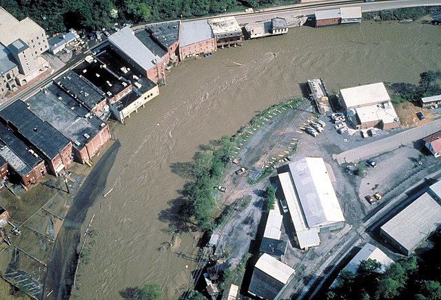
English: Aerial view of flooding on the Levisa Fork River in Grundy, Virginia, USA, in 1984. The town of Grundy, the State of Virginia, and the U.S. Army Corps of Engineers are cooperating in a project to relocate the business center of the town away from the flood-prone areas along the river. |
|||
| Datum | ||||
| Quelle |
U.S. Army Corps of Engineers Digital Visual Library Image page Image description page Digital Visual Library home page |
|||
| Urheber | U.S. Army Corps of Engineers, photographer not specified or unknown | |||
| Genehmigung (Weiternutzung dieser Datei) |
|
|||
| Ort | Grundy, Virginia, USA |
| Kameraposition | | Dieses und weitere Bilder auf OpenStreetMap |
|---|
Dateiversionen
Klicke auf einen Zeitpunkt, um diese Version zu laden.
| Version vom | Vorschaubild | Maße | Benutzer | Kommentar | |
|---|---|---|---|---|---|
| aktuell | 03:46, 31. Mär. 2007 | | 1.500 × 1.023 (514 KB) | DanMS (Diskussion | Beiträge) | {{Information | Description = {{en|Aerial view of flooding on the Levisa Fork River in Grundy, Virginia, USA, in 1984. The town of Grundy, the State of Virginia, and the U.S. Army Corps of Engineers are cooperating in a project to relocate the business |
Du kannst diese Datei nicht überschreiben.
Dateiverwendung
Keine Seiten verwenden diese Datei.
Globale Dateiverwendung
Die nachfolgenden anderen Wikis verwenden diese Datei:
- Verwendung auf ast.wikipedia.org
- Verwendung auf de.wikipedia.org
- Verwendung auf en.wikipedia.org
- Verwendung auf fr.wikipedia.org