File:Guangzhou Metro physical layout 2010 zh-cn.svg
Jump to navigation
Jump to search

Size of this PNG preview of this SVG file: 466 × 599 pixels. Other resolutions: 187 × 240 pixels | 373 × 480 pixels | 597 × 768 pixels | 796 × 1,024 pixels | 1,593 × 2,048 pixels | 1,400 × 1,800 pixels.
Original file (SVG file, nominally 1,400 × 1,800 pixels, file size: 399 KB)
Captions
Captions
Add a one-line explanation of what this file represents
| Description |
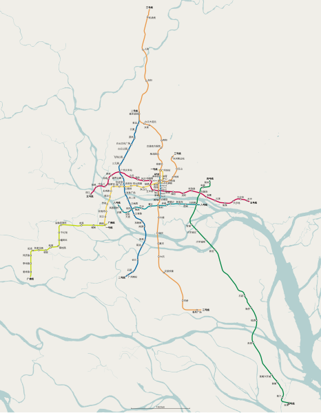
中文(中国大陆):2010 年新线开通后广州地铁线路地理走向图。底图导出并衍生自 OpenStreetMap(边界 22.7806° N, 113.0515° E–23.4152° N, 113.5870° E,比例尺 scale 1 : 152226)。 |
| Date | (UTC) |
| Source | |
| Author |
|
| This is a retouched picture, which means that it has been digitally altered from its original version. Modifications: Translated into Chinese. The original can be viewed here: Guangzhou Metro physical layout 2010 en.svg:
|
I, the copyright holder of this work, hereby publish it under the following license:
This file is licensed under the Creative Commons Attribution-Share Alike 3.0 Unported license.
- You are free:
- to share – to copy, distribute and transmit the work
- to remix – to adapt the work
- Under the following conditions:
- attribution – You must give appropriate credit, provide a link to the license, and indicate if changes were made. You may do so in any reasonable manner, but not in any way that suggests the licensor endorses you or your use.
- share alike – If you remix, transform, or build upon the material, you must distribute your contributions under the same or compatible license as the original.
Original upload log[edit]
This image is a derivative work of the following images:
- File:Guangzhou_Metro_physical_layout_2010_en.svg licensed with Cc-by-sa-3.0
- 2011-01-07T18:25:24Z Kxx 1400x1800 (411123 Bytes) code clean up
- 2011-01-07T18:24:38Z Kxx 1400x1800 (566296 Bytes) simplified paths
- 2011-01-07T17:22:31Z Kxx 1400x1800 (572048 Bytes) "Optimized SVG" output from Inkscape
- 2011-01-07T17:21:44Z Kxx 1400x1800 (736331 Bytes) minor adjustments
- 2011-01-07T07:29:41Z Kxx 1400x1800 (571195 Bytes) "Optimized SVG" output from Inkscape
- 2011-01-07T07:28:01Z Kxx 1400x1800 (734969 Bytes) {{Information |Description={{en|1=Physical layout of Guangzhou Metro system after 2010 expansion. Base map exported from OpenStreetMap with bounding box {{nowrap|22.7806° N, 113.0515° E}}–{{nowrap|23.4152° N, 113.5870°
Uploaded with derivativeFX
File history
Click on a date/time to view the file as it appeared at that time.
| Date/Time | Thumbnail | Dimensions | User | Comment | |
|---|---|---|---|---|---|
| current | 18:51, 2 July 2011 | | 1,400 × 1,800 (399 KB) | Kxx (talk | contribs) | explicitly specified height, width and viewbox |
| 23:45, 12 January 2011 |  | 1,400 × 1,800 (400 KB) | Kxx (talk | contribs) | "Optimized SVG" from Inkscape | |
| 23:42, 12 January 2011 |  | 1,400 × 1,800 (546 KB) | Kxx (talk | contribs) | {{Information |Description={{zh-cn|1=2010 年新线开通后广州地铁线路地理走向图。底图导出并衍生自 OpenStreetMap(边界 {{nowrap|22.7806° N, 113.0515° E}}–{{nowrap|23.4152° N, 113.5870° E}},比例尺 {{nowrap|scale 1 : 1522 |
You cannot overwrite this file.
File usage on Commons
There are no pages that use this file.