File:Guatemala - Location Map (2013) - GTM - UNOCHA.svg

原始文件 (SVG文件,尺寸为250 × 250像素,文件大小:232 KB)
说明
说明
摘要
[编辑]_-_GTM_-_UNOCHA.svg&action=edit§ion=1)
| 描述 |
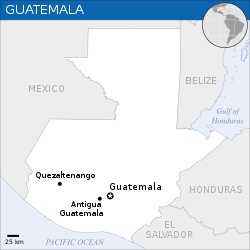
English: Locator map of Guatemala. |
| 日期 | |
| 来源 |
English: Guatemala Locator Map (ReliefWeb), UNCS, ESRI |
| 作者 | |
| SVG开发 |
许可协议
[编辑]_-_GTM_-_UNOCHA.svg&action=edit§ion=2)
- 您可以自由地:
- 共享 – 复制、发行并传播本作品
- 修改 – 改编作品
- 惟须遵守下列条件:
- 署名 – 您必须对作品进行署名,提供授权条款的链接,并说明是否对原始内容进行了更改。您可以用任何合理的方式来署名,但不得以任何方式表明许可人认可您或您的使用。
 This map is part of a collection of 216 free country maps, created by the UN Office for the Coordination of Humanitarian Affairs (OCHA), to be used in print, web or broadcast products.
The ReliefWeb Location Maps released here are maps that highlight a country, its capital, major populated places and the surrounding regions. Attribution Requirements
Using the map without modifications: ensure that the sources and the disclaimer are below the map. Credit as follows: "Credit: OCHA". For use with alteration: remove the OCHA logo and disclaimer following any modification to the map, but keep the data sources as mentioned below the map. Credit the modified map as follows: "Based on OCHA map". You are responsible for the content of your map. We are keen to receive your feedback and hear how you used OCHA's maps. We would be grateful if you would notify us by e-mail and share your work with us. UN Disclaimer
The designations employed and the presentation of material of this map do not imply the expression of any opinion whatsoever on the part of the Secretariat of the United Nations concerning the legal status of any country, territory, city or area or of its authorities or concerning the delimitation of its frontiers or boundaries. |
文件历史
点击某个日期/时间查看对应时刻的文件。
| 日期/时间 | 缩略图 | 大小 | 用户 | 备注 | |
|---|---|---|---|---|---|
| 当前 | 2022年11月19日 (六) 02:38 | | 250 × 250(232 KB) | Pengetik-AM(留言 | 贡献) | File uploaded using svgtranslate tool (https://svgtranslate.toolforge.org/). Added translation for id. |
| 2016年9月13日 (二) 16:02 |  | 250 × 250(231 KB) | Wereldburger758(留言 | 贡献) | Resized page to drawing. Removal watermark. Validation of image. | |
| 2014年8月20日 (三) 20:46 |  | 250 × 250(284 KB) | Pharos(留言 | 贡献) | == {{int:filedesc}} == {{Information |description={{en|1=Locator map of Guatemala.}} |date=2013 |source={{en|1=[http://reliefweb.int/map/guatemala/guatemala-location-map-2013 Guatemala Locator Map (ReliefWeb)], UNCS, ESRI}} |author={... |
您不可以覆盖此文件。
文件用途
没有页面使用本文件。
全域文件用途
以下其他wiki使用此文件:
- bh.wikipedia.org上的用途
- es.wikipedia.org上的用途
- id.wikipedia.org上的用途
- sd.wikipedia.org上的用途
- ta.wikipedia.org上的用途
_-_GTM_-_UNOCHA.svg&oldid=751043990)