File:GulaMons SifMons northeast.jpg
跳至導覽
跳至搜尋

預覽大小:750 × 600 像素。 其他解析度:300 × 240 像素 | 600 × 480 像素 | 960 × 768 像素 | 1,280 × 1,024 像素 | 2,560 × 2,048 像素 | 5,000 × 4,000 像素。
原始檔案 (5,000 × 4,000 像素,檔案大小:1.87 MB,MIME 類型:image/jpeg)
說明
說明
添加單行說明來描述出檔案所代表的內容
摘要
[編輯]
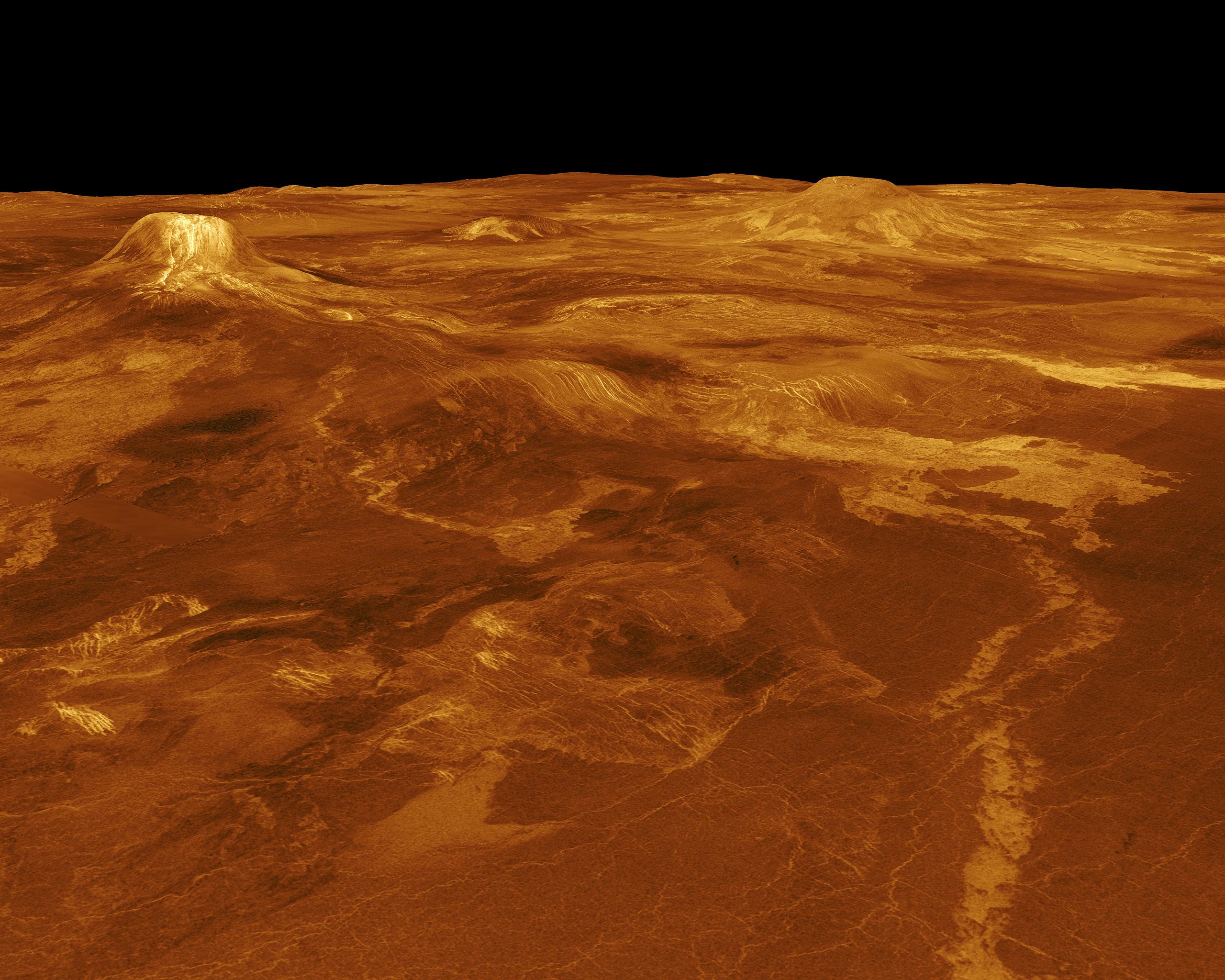
| 描述 | A portion of western Eistla Regio is displayed in this three-dimensional perspective view of the surface of Venus. The viewpoint is located 1,100 kilometers (682 miles) northeast of Gula Mons at an elevation of 7.5 kilometers (4.6 miles). Lava flows extend for hundreds of kilometers across the fractured plains shown in the foreground to the base of Gula Mons. The viewpoint is to the southwest with Gula Mons appearing at the left just below the horizon. Gula Mons, a 3 kilometers (1.8 miles) high volcano, is located at approximately 22 degrees north latitude, 359 degrees east longitude. Sif Mons, a volcano with a diameter of 300 kilometers (180 miles) and a height of 2 kilometers (1.2 miles), appears to the right of Gula Mons. The distance between Sif Mons and Gula Mons is approximately 730 kilometers (453 miles). Magellan synthetic aperture radar data is combined with radar altimetry to develop a three-dimensional map of the surface. Ray tracing (rays as if from a light source are cast in a computer to intersect the surface) simulate a perspective view. Simulated color and a digital elevation map developed by Randy Kirk of the U.S. Geological Survey, are used to enhance small scale structure. The simulated hues are based on color images recorded by the Soviet Venera 13 and 14 spacecraft. The image was produced at the JPL Multimission Image Processing Laboratory by Eric De Jong, Jeff Hall and Myche McAuley, and is a single frame from a video released at a March 5, 1991, JPL news conference. |
| 來源 | http://photojournal.jpl.nasa.gov/catalog/PIA00102 |
| 作者 | JPL/NASA |
| 此標籤不表示文件的著作權狀態。任何文件在附有此標籤的同時還需要一個有效的著作權標籤。請參閱許可協議說明頁面以了解更多資訊。 其他語言:
|
授權條款
[編輯]
| 本作品由NASA創作,屬於公有領域。根據NASA的版權政策:“NASA的創作除非另有聲明否則不受版權保護。”(參見:Template:PD-USGov/zh,NASA版權政策或JPL圖像使用政策) | ||
 |
警告:
|
檔案歷史
點選日期/時間以檢視該時間的檔案版本。
| 日期/時間 | 縮圖 | 尺寸 | 使用者 | 備註 | |
|---|---|---|---|---|---|
| 目前 | 2007年11月25日 (日) 21:40 | | 5,000 × 4,000(1.87 MB) | Lotse(留言 | 貢獻) | {{Information |Description=A portion of western Eistla Regio is displayed in this three-dimensional perspective view of the surface of Venus. The viewpoint is located 1,100 kilometers (682 miles) northeast of Gula Mons at an elevation of 7.5 kilometers (4 |
無法覆蓋此檔案。
檔案用途
沒有使用此檔案的頁面。
全域檔案使用狀況
以下其他 wiki 使用了這個檔案:
- en.wikipedia.org 的使用狀況
- he.wikipedia.org 的使用狀況
- zh.wikipedia.org 的使用狀況