File:H1N1 Philippines Map.svg
Jump to navigation
Jump to search

Size of this PNG preview of this SVG file: 384 × 599 pixels. Other resolutions: 154 × 240 pixels | 308 × 480 pixels | 492 × 768 pixels | 656 × 1,024 pixels | 1,313 × 2,048 pixels | 2,000 × 3,120 pixels.
Original file (SVG file, nominally 2,000 × 3,120 pixels, file size: 1.26 MB)
Captions
Captions
Add a one-line explanation of what this file represents
Summary
[edit]
| Description |
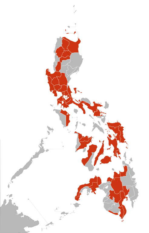
English: Map of the Philippines of the 2009 H1N1 flu outbreak.
confirmed death and infections
confirmed infections
unconfirmed infections
The map can be edited very rapidly because it is a current event which is changing hour by hourEspañol: Mapa de Filipinas de la pandemia de influenza H1N1 de 2009.
muertes confirmadas
infecciones confirmadas
infecciones no confirmadas
Este mapa puede cambiar muy rápidamente, dado que es un evento actual que cambia hora a hora. |
| Source | Own work |
| Author | Vrysxy |
| Permission (Reusing this file) |
This file is licensed under the Creative Commons Attribution-Share Alike 3.0 Unported license.
|
| Other versions | File:Ph swineflumap.png |
File history
Click on a date/time to view the file as it appeared at that time.
| Date/Time | Thumbnail | Dimensions | User | Comment | |
|---|---|---|---|---|---|
| current | 19:34, 16 May 2020 | | 2,000 × 3,120 (1.26 MB) | Hariboneagle927 (talk | contribs) | Made to match File:Ph AH1N1 map.PNG (August 9, 2009), before the whole CAR was blanket shaded with black to denote deaths in the region (No province breakdown) in general. It is hard to ascertain officially confirmed AH1N1 deaths. |
| 04:41, 14 July 2009 |  | 2,000 × 3,120 (1.26 MB) | Vrysxy (talk | contribs) | Updated as of July 13 | |
| 21:48, 16 June 2009 |  | 2,000 × 3,120 (1.26 MB) | Vrysxy (talk | contribs) | Updated as of June 16th | |
| 08:01, 6 June 2009 |  | 2,000 × 3,120 (1.26 MB) | Vrysxy (talk | contribs) | Updating as of June 6 | |
| 23:01, 28 May 2009 |  | 2,000 × 3,120 (1.26 MB) | Vrysxy (talk | contribs) | {{Information |Description={{en|1=Map of Panama of the 2009 H1N1 flu outbreak. <br /> {{legend|#000000|confirmed death and infections}} {{legend|#cd3412|confirmed infections}} {{legend|#eaa912|unconfirmed infections}} The map can be edited very rapidly be |
You cannot overwrite this file.
File usage on Commons
The following 4 pages use this file:
File usage on other wikis
The following other wikis use this file:
- Usage on en.wikipedia.org
- Talk:2009 swine flu pandemic by country/Archive 1
- File talk:H1N1 Philippines Map.svg
- 2009 swine flu pandemic in the Philippines
- Talk:2009 swine flu pandemic in the Philippines
- File talk:Influenza A(H1N1) map of the Philippines as of 6 June 2009.png
- Template talk:2009 flu pandemic table in the Philippines table
- Talk:2009 swine flu pandemic in Asia
- Wikipedia talk:Tambayan Philippines/Archive 22
- File talk:Ph AH1N1 map.PNG
- 2009 swine flu pandemic in the Philippines by region
- Usage on es.wikipedia.org
- Usage on fr.wikipedia.org
- Usage on pl.wikipedia.org
- Usage on pt.wikipedia.org
- Usage on tl.wikipedia.org
_map_of_the_Philippines_as_of_6_June_2009.png)