File:HK Route10 map.svg
Jump to navigation
Jump to search

Size of this PNG preview of this SVG file: 800 × 582 pixels. Other resolutions: 320 × 233 pixels | 640 × 466 pixels | 1,024 × 746 pixels | 1,280 × 932 pixels | 2,560 × 1,864 pixels | 1,607 × 1,170 pixels.
Original file (SVG file, nominally 1,607 × 1,170 pixels, file size: 155 KB)
Captions
Captions
Add a one-line explanation of what this file represents
Summary[edit]

|
This file requires updating because: Update Route 6 section as TKO-LT tunnel opened in 2022 and rest of the route 6 will be opened in 2025. In doing so, you could add a timestamp to the file.
|
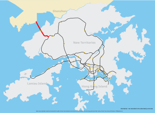
| Description | Map of Route 10, Hong Kong, coloured red |
| Date | |
| Source | self-made based on Image:Hong Kong Strategic Route Map.svg |
| Author | Raphaelmak |
Licensing[edit]
| I, the copyright holder of this work, release this work into the public domain. This applies worldwide. In some countries this may not be legally possible; if so: I grant anyone the right to use this work for any purpose, without any conditions, unless such conditions are required by law. |
File history
Click on a date/time to view the file as it appeared at that time.
| Date/Time | Thumbnail | Dimensions | User | Comment | |
|---|---|---|---|---|---|
| current | 21:02, 19 May 2013 | | 1,607 × 1,170 (155 KB) | Jc86035 (talk | contribs) | Updated Route 8 |
| 06:02, 21 March 2008 |  | 1,607 × 1,170 (155 KB) | Raphaelmak (talk | contribs) | Updating; thickening | |
| 13:11, 18 February 2008 |  | 1,607 × 1,170 (155 KB) | Raphaelmak (talk | contribs) | == Summary == {{Information |Description=Map of w:Route 10 (Hong Kong), w:Hong Kong, coloured red |Source=self-made based on Image:Hong Kong Strategic Route Map.svg |Date=2008-02-18 |Author= Raphaelmak|Permission= |o |
You cannot overwrite this file.
File usage on Commons
The following page uses this file:
File usage on other wikis
The following other wikis use this file: