File:HYU location satelite(province scale).png
Jump to navigation
Jump to search
No higher resolution available.
HYU_location_satelite(province_scale).png (500 × 374 pixels, file size: 389 KB, MIME type: image/png)
Captions
Captions
Add a one-line explanation of what this file represents
Summary[edit]
.png&action=edit§ion=1)
| Description |
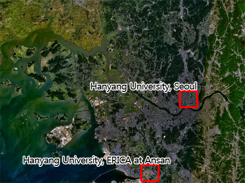
English: Location of Hanyang University
한국어: 한양대학교의 위치 위성사진 |
| Date | |
| Source | Own work + File:Seoul 126.73851E 37.61213N.jpg |
| Author | Modamoda |
| Other versions | File:HYU location satelite(contry scale).png |
.png)
Licensing[edit]
.png&action=edit§ion=2)
I, the copyright holder of this work, hereby publish it under the following license:
This file is licensed under the Creative Commons Attribution-Share Alike 3.0 Unported license.
- You are free:
- to share – to copy, distribute and transmit the work
- to remix – to adapt the work
- Under the following conditions:
- attribution – You must give appropriate credit, provide a link to the license, and indicate if changes were made. You may do so in any reasonable manner, but not in any way that suggests the licensor endorses you or your use.
- share alike – If you remix, transform, or build upon the material, you must distribute your contributions under the same or compatible license as the original.
File history
Click on a date/time to view the file as it appeared at that time.
| Date/Time | Thumbnail | Dimensions | User | Comment | |
|---|---|---|---|---|---|
| current | 16:08, 6 December 2009 | | 500 × 374 (389 KB) | Modamoda (talk | contribs) | {{Information |Description={{en|1=Location of Hanyang University}} {{ko|1=한양대학교의 위치 위성사진}} |Source=Own work + File:Seoul 126.73851E 37.61213N.jpg |Author=Modamoda |Date=2009-12-07 |Permission= |other_versions |
You cannot overwrite this file.
File usage on Commons
The following page uses this file:
File usage on other wikis
The following other wikis use this file:
- Usage on vi.wikipedia.org
.png&oldid=486323966)