File:Haima 2016-10-19 0340Z.png
跳转到导航
跳转到搜索

本预览的尺寸:450 × 600像素。 其他分辨率:180 × 240像素 | 360 × 480像素 | 576 × 768像素 | 768 × 1,024像素 | 1,536 × 2,048像素 | 3,000 × 4,000像素。
原始文件 (3,000 × 4,000像素,文件大小:15.7 MB,MIME类型:image/png)
说明
说明
添加一行文字以描述该文件所表现的内容
摘要[编辑]
| 描述 |
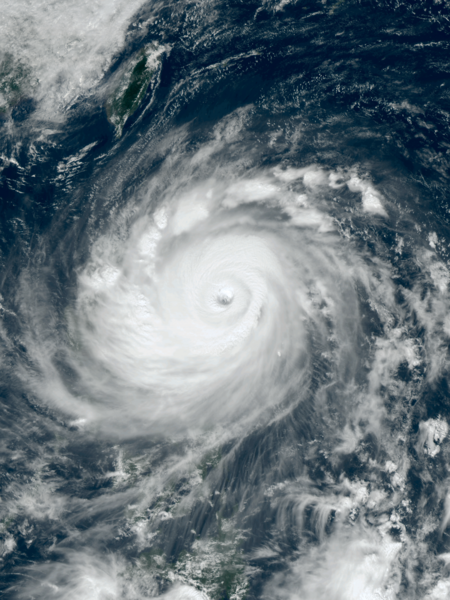
English: Typhoon Haima approaching the Philippines at peak intensity on October 19, 2016. |
| 日期 | |
| 来源 | RealEarth™ |
| 作者 | AHI image captured by the Japan Meteorology Agency’s Himawari-8 satellite |
| 相机位置 | | 在以下服务上查看本图像和附近其他图像: OpenStreetMap |
|---|
许可协议[编辑]
This image was produced by the SSEC/CIMSS, University of Wisconsin–Madison. All the images published on their website can be freely used, as long as the source is acknowledged. (disclaimer (archive))
|
 |

文件历史
点击某个日期/时间查看对应时刻的文件。
| 日期/时间 | 缩略图 | 大小 | 用户 | 备注 | |
|---|---|---|---|---|---|
| 当前 | 2022年12月17日 (六) 01:16 | | 3,000 × 4,000(15.7 MB) | TheWxResearcher(留言 | 贡献) | 500m resolution |
| 2016年10月19日 (三) 11:16 |  | 1,536 × 2,048(5.14 MB) | Meow(留言 | 贡献) | User created page with UploadWizard |
您不可以覆盖此文件。
文件用途
以下2个页面使用本文件:
全域文件用途
以下其他wiki使用此文件:
- de.wikipedia.org上的用途
- en.wikipedia.org上的用途
- fi.wikipedia.org上的用途
- ja.wikipedia.org上的用途
- ko.wikipedia.org上的用途
- pt.wikipedia.org上的用途
- th.wikipedia.org上的用途
- tl.wikipedia.org上的用途
- uk.wikipedia.org上的用途
- war.wikipedia.org上的用途
- www.wikidata.org上的用途
- zh.wikipedia.org上的用途