File:Haiti-2010-quake.png
Jump to navigation
Jump to search
No higher resolution available.
Haiti-2010-quake.png (326 × 350 pixels, file size: 37 KB, MIME type: image/png)
Captions
Captions
Add a one-line explanation of what this file represents
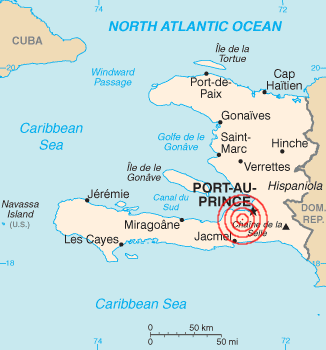
| Description | 2010 Haiti earthquake epicenter | |||
| Date | ||||
| Source | English Wikipedia, based on [1] with location info from [2]. | |||
| Author | Based on U.S. govt work, rings added by Evercat | |||
| Permission (Reusing this file) |
|
|||
| Other versions | File:Haiti_map.png |

![[1]](https://en.wikipedia.org/wiki/File:Haiti_map.png)
File history
Click on a date/time to view the file as it appeared at that time.
| Date/Time | Thumbnail | Dimensions | User | Comment | |
|---|---|---|---|---|---|
| current | 00:26, 13 January 2010 | | 326 × 350 (37 KB) | Warko (talk | contribs) | {{Information |Description=2010 Haiti earthquake |Source=[http://en.wikipedia.org/wiki/File:Haiti-2010-quake.png English Wikipedia], based on [http://neic.usgs.gov/neis/bulletin/neic_rja6_l.html]. |Date= 12 January 2010 |Author=Based on U.S. govt work, ri |
You cannot overwrite this file.
File usage on Commons
There are no pages that use this file.
File usage on other wikis
The following other wikis use this file:
- Usage on ar.wikipedia.org
- Usage on bg.wikinews.org
- Usage on bs.wikipedia.org
- Usage on ckb.wikipedia.org
- Usage on cs.wikipedia.org
- Usage on cy.wikipedia.org
- Usage on da.wikipedia.org
- Usage on de.wikipedia.org
- Usage on de.wikinews.org
- Usage on en.wikipedia.org
- Usage on eo.wikipedia.org
- Usage on et.wikipedia.org
- Usage on fa.wikipedia.org
- Usage on fi.wikipedia.org
- Usage on fi.wikinews.org
- Usage on fr.wikipedia.org
- Usage on fr.wikinews.org
- Haïti : important séisme de magnitude 7
- Haïti : la mission de l'ONU assure la sécurité après le séisme
- Haïti : 7 500 soldats américains supplémentaires attendus
- Haïti : l'aide humanitaire toujours confrontée aux problèmes logistiques
- Haïti : fin des opérations de recherche de survivants
- 5,3 milliards de dollars pour la reconstruction d'Haïti
- Usage on gd.wikipedia.org
- Usage on hi.wikipedia.org
- Usage on hr.wikipedia.org
- Usage on is.wikipedia.org
- Usage on mg.wikipedia.org
- Usage on mr.wikipedia.org
- Usage on ms.wikipedia.org
- Usage on my.wikipedia.org
- Usage on nds.wikipedia.org
- Usage on pl.wikinews.org
- Usage on pt.wikipedia.org
- Usage on ro.wikipedia.org
- Usage on ro.wikinews.org
- Usage on sh.wikipedia.org
- Usage on sr.wikipedia.org
- Usage on sv.wikipedia.org
- Usage on szl.wikipedia.org
- Usage on tl.wikipedia.org
- Usage on tr.wikipedia.org
View more global usage of this file.