File:Hakimasue Asakura City 20170707.png
Jump to navigation
Jump to search
No higher resolution available.
Hakimasue_Asakura_City_20170707.png (461 × 258 pixels, file size: 299 KB, MIME type: image/png)
Captions
Captions
Add a one-line explanation of what this file represents
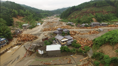
| Description | Akatani River was overflowed by the Northern Kyūshū Heavy Rain in Asakura City, Fukuoka Prefecture on July 7, 2017. | ||||
| Date | |||||
| Source | 平成29年6月30日からの梅雨前線に伴う大雨及び台風3号に関する情報|国土地理院 | ||||
| Author | 国土地理院企画部防災推進室 | ||||
| Permission (Reusing this file) |
This file is licensed under the Creative Commons Attribution 4.0 International license. Attribution: 国土地理院ウェブサイト
|

| Camera location | | View this and other nearby images on: OpenStreetMap |
|---|
File history
Click on a date/time to view the file as it appeared at that time.
| Date/Time | Thumbnail | Dimensions | User | Comment | |
|---|---|---|---|---|---|
| current | 14:21, 10 July 2017 | | 461 × 258 (299 KB) | Scanyaro (talk | contribs) | {{Information |Description=Akaya River was overflowed by Kyūshū Heavy Rain in Asakura, City, Fukuoka Prefecture on July 7, 2017. |Source=[http://www.gsi.go.jp/BOUSAI/H29hukuoka_ooita-heavyrain.h... |
You cannot overwrite this file.
File usage on Commons
The following page uses this file:
File usage on other wikis
The following other wikis use this file:
- Usage on ar.wikipedia.org
- Usage on de.wikipedia.org
- Usage on en.wikipedia.org
- Usage on ja.wikipedia.org
- Usage on ja.wikinews.org
- Usage on nds.wikipedia.org
- Usage on nl.wikipedia.org
- Usage on www.wikidata.org