File:Halley compass variations 1702.jpg
Salta a la navegació
Salta a la cerca
Mida d'aquesta previsualització: 481 × 599 píxels. Altres resolucions: 193 × 240 píxels | 385 × 480 píxels | 642 × 800 píxels.
Fitxer original (642 × 800 píxels, mida del fitxer: 150 Ko, tipus MIME: image/jpeg)
Llegendes
Llegendes
Afegeix una explicació d'una línia del que representa aquest fitxer
Resum
[modifica]
| Descripció |
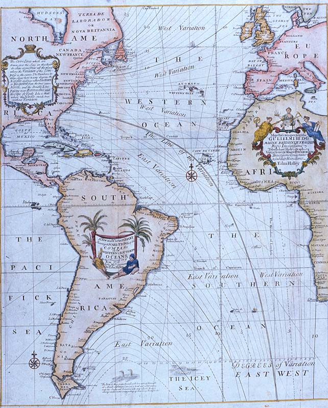
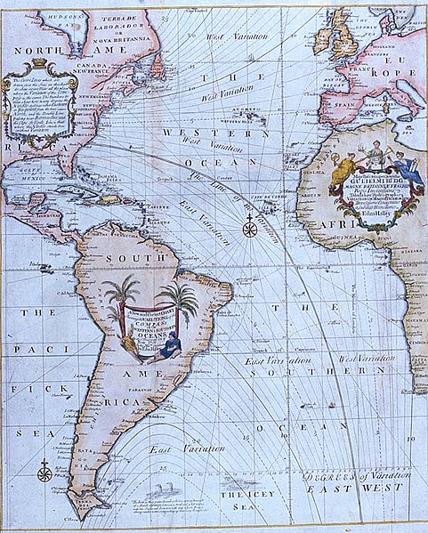
Edmond Halley's New and Correct Chart Shewing the Variations of the Compass (1701), the first chart to show lines of equal magnetic variation. See also exhibit G201:1/1 at the UK National Maritime Museum. The NMM scan may however be protected by copyright in the UK. |
| Data | |
| Font |
Plate 22 from Mount & Page's 1702 "Atlas Maritimus Novus, or the New Sea-Atlas." This image was found at [1], in the online map database of the Louisiana State Museum, accession number 1982.077.020 |
| Autor | Edmond Halley |
| Altres versions | Halley compass variations 1720.jpg |
![[1]](http://lsm.crt.state.la.us/lsmmaps/jpegs/1982.077.020.jpg)
Llicència
[modifica]
|
Aquest material està en domini públic als Estats Units i als altres països on el dret d'autor s'estén per 100 anys (o menys) després de la mort de l'autor. | |
| Aquest fitxer està identificat com a lliure de restriccions conegudes sota la llei de drets d'autor, inclosos els drets veïns. | |
Historial del fitxer
Cliqueu una data/hora per veure el fitxer tal com era aleshores.
| Data/hora | Miniatura | Dimensions | Usuari/a | Comentari | |
|---|---|---|---|---|---|
| actual | 13:44, 2 maig 2008 | | 642 × 800 (150 Ko) | Jheald (discussió | contribucions) | {{Information |Description=Edmond Halley's ''New and Correct Chart Shewing the Variations of the Compass'' (1701), the first chart to show lines of equal magnetic variation. <p>See also exhibit [http://www.n |
No podeu sobreescriure aquest fitxer.
Ús del fitxer
No hi ha pàgines que utilitzin aquest fitxer.
Ús global del fitxer
Utilització d'aquest fitxer en altres wikis:
- Utilització a bn.wikipedia.org
- Utilització a ca.wikipedia.org
- Utilització a en.wikipedia.org
- Utilització a eo.wikipedia.org
- Utilització a es.wikipedia.org
- Utilització a fi.wikipedia.org
- Utilització a fr.wikipedia.org
- Utilització a he.wikipedia.org
- Utilització a it.wikipedia.org
- Utilització a kn.wikipedia.org
- Utilització a nds.wikipedia.org
- Utilització a nn.wikipedia.org
- Utilització a no.wikipedia.org
- Utilització a pt.wikipedia.org
- Utilització a ru.wikipedia.org
- Utilització a sl.wikipedia.org
- Utilització a sv.wikipedia.org
- Utilització a th.wikipedia.org
- Utilització a uk.wikipedia.org
- Utilització a vi.wikipedia.org