File:Harvey 2017-08-25 2231Z.png
跳转到导航
跳转到搜索
本预览的尺寸:452 × 599像素。 其他分辨率:181 × 240像素 | 362 × 480像素 | 579 × 768像素 | 773 × 1,024像素 | 1,546 × 2,048像素 | 4,000 × 5,300像素。
原始文件 (4,000 × 5,300像素,文件大小:32.54 MB,MIME类型:image/png)
说明
说明
添加一行文字以描述该文件所表现的内容
摘要
[编辑]
| 描述 |
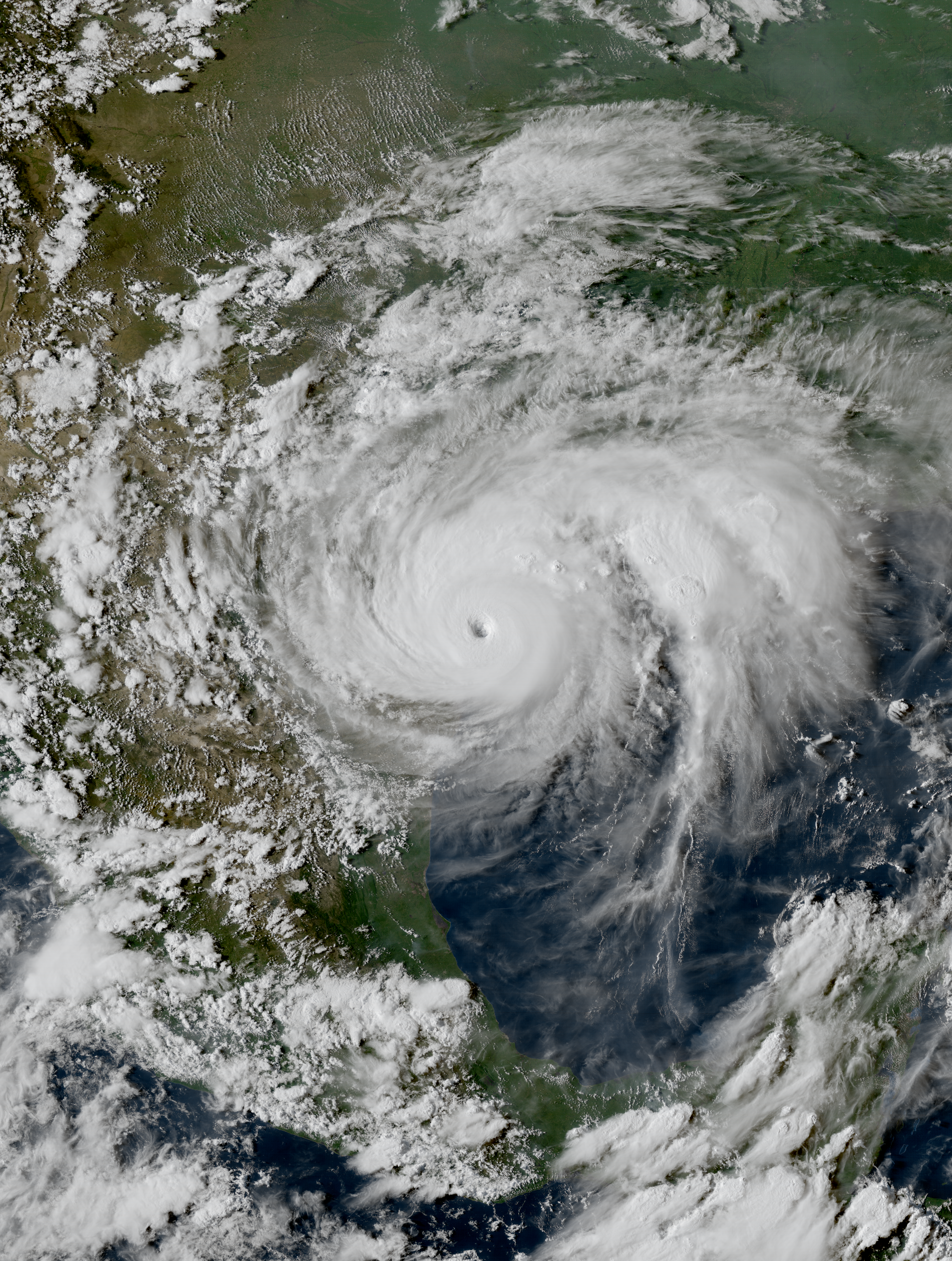
English: Hurricane Harvey near the coast of Texas at peak intensity late on August 25, 2017. |
| 日期 | |
| 来源 | RAMMB/CIRA SLIDER |
| 作者 | ABI image captured by NOAA’s GOES-16 satellite |
| 相机位置 | | 在以下服务上查看本图像和附近其他图像: OpenStreetMap |
|---|
许可协议
[编辑]
本图像属于公有领域,因该作品最初来自于美国国家海洋和大气管理局职员的职务作品。
|
文件历史
点击某个日期/时间查看对应时刻的文件。
| 日期/时间 | 缩略图 | 大小 | 用户 | 备注 | |
|---|---|---|---|---|---|
| 当前 | 2021年5月15日 (六) 01:18 | | 4,000 × 5,300(32.54 MB) | Supportstorm(留言 | 贡献) | Reverted to version as of 19:43, 21 December 2019 (UTC) |
| 2021年5月15日 (六) 00:15 |  | 451 × 499(532 KB) | Super Cyclonic Storm Corona(留言 | 贡献) | Cropped a bit, added a little more contrast. | |
| 2019年12月21日 (六) 19:43 |  | 4,000 × 5,300(32.54 MB) | Supportstorm(留言 | 贡献) | 500m resolution, re-projected to equirectangular | |
| 2017年8月26日 (六) 12:49 |  | 1,800 × 2,400(7.28 MB) | Meow(留言 | 贡献) | Reverted to version as of 07:06, 26 August 2017 (UTC) Making a picture at sunset so bright is not natural, and the ratio was unnecessary changed. | |
| 2017年8月26日 (六) 08:54 |  | 1,700 × 2,340(7.71 MB) | ChocolateTrain(留言 | 贡献) | Slightly enhanced | |
| 2017年8月26日 (六) 07:06 |  | 1,800 × 2,400(7.28 MB) | Meow(留言 | 贡献) | User created page with UploadWizard |
您不可以覆盖此文件。
文件用途
以下7个页面使用本文件:
- August 2017
- Commons:Featured picture candidates/File:Harvey 2017-08-25 2231Z.png
- Commons:Featured picture candidates/Log/September 2017
- Commons:WikiProject Aviation/recent uploads/2017 August 26
- Commons:WikiProject Aviation/recent uploads/2019 December 21
- File:2017 Events montage 16-grid version.jpg
- File:Harvey 2017-08-25 223036Z.png(文件重定向)
全域文件用途
以下其他wiki使用此文件:
- de.wikipedia.org上的用途
- en.wikipedia.org上的用途
- Talk:Tropical cyclone
- Talk:Saffir–Simpson scale
- Talk:Great Hurricane of 1780
- Talk:2004 Atlantic hurricane season
- Talk:Hurricane Charley
- Talk:Hurricane Bob
- Talk:Hurricane Alex (2004)
- Talk:Hurricane Camille
- Talk:1900 Galveston hurricane
- Talk:Hurricane Frances
- Talk:Hurricane Ivan
- Talk:Hurricane Elena
- Talk:Hurricane Jeanne
- Talk:1935 Labor Day hurricane
- Talk:Hurricane Donna
- Talk:Hurricane David
- Talk:2005 Atlantic hurricane season
- Talk:1950 Atlantic hurricane season
- Talk:Hurricane Carla
- Talk:1948 Atlantic hurricane season
- Talk:1987 Atlantic hurricane season
- Talk:1933 Atlantic hurricane season
- Talk:2003 Atlantic hurricane season
- Talk:1969 Atlantic hurricane season
- Talk:Hurricane Alberto (2000)
- Talk:1922 Atlantic hurricane season
- Talk:Hurricane Gilbert
- Talk:1928 Okeechobee hurricane
- Talk:1956 Atlantic hurricane season
- Talk:Hurricane Flora
- Talk:Hurricane Faith
- Talk:Hurricane Ginger
- Talk:Hurricane Allen
- Talk:Hurricane Hilda
- Talk:1952 Atlantic hurricane season
- Talk:1971 Atlantic hurricane season
- Talk:1966 Atlantic hurricane season
- Talk:Hurricane Mitch
- Talk:1997 Atlantic hurricane season
- Talk:Hurricane Dennis
- Talk:Hurricane Andrew
- Talk:Hurricane Dora (1964)
- Talk:Hurricane Emily (2005)
- Talk:1926 Miami hurricane
- Talk:2006 Atlantic hurricane season
- Talk:Hurricane Ethel (1960)
- Talk:Hurricane Katrina
查看此文件的更多全域用途。