File:Harz map.png
跳转到导航
跳转到搜索

本预览的尺寸:800 × 482像素。 其他分辨率:320 × 193像素 | 640 × 385像素 | 1,024 × 617像素 | 1,280 × 771像素 | 2,529 × 1,523像素。
原始文件 (2,529 × 1,523像素,文件大小:3.15 MB,MIME类型:image/png)
说明
说明
添加一行文字以描述该文件所表现的内容
摘要
[编辑]
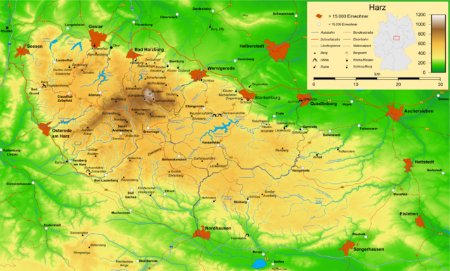
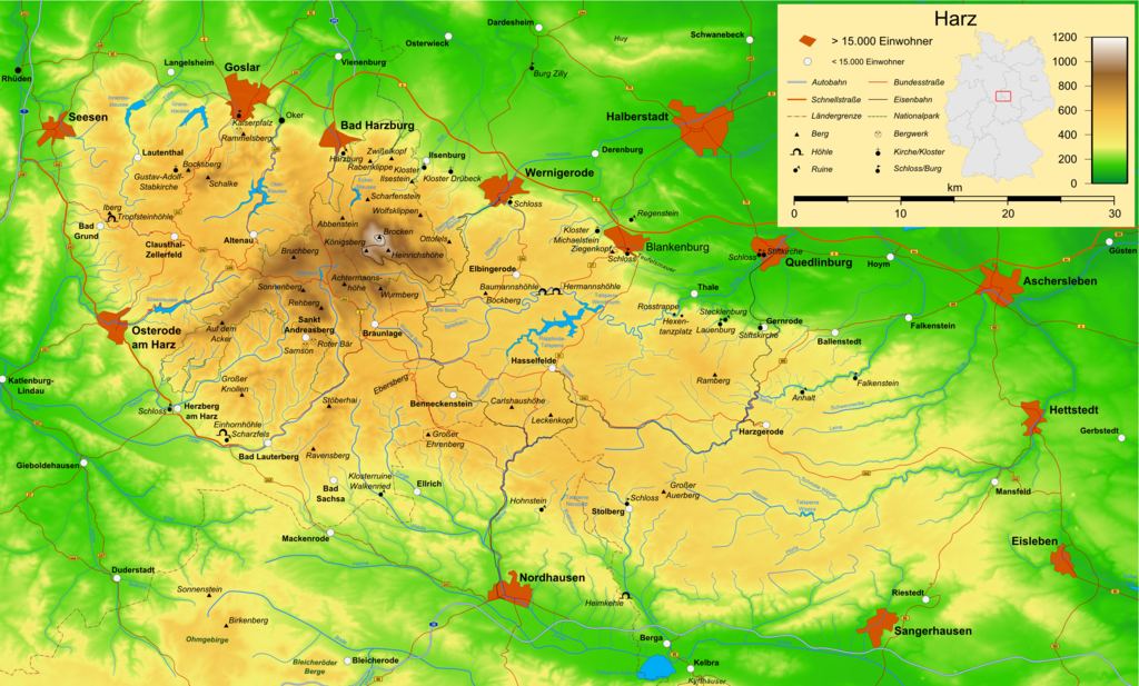
| 描述 | Map of the Harz mountains in Germany with mountains, rivers, lakes, reservoirs, all highways, all Bundesstraßen, Harzquerbahn, Brockenbahn, Selketalbahn, major towns and sights. |
| 日期 | |
| 来源 | 自己的作品 |
| 作者 | Bamse |
| 其他版本 |
此文件衍生的作品: Karte Harzer Schmalspurbahnen.png  , ,  , ,  |
该地图是使用通用制图工具创建的: https://www.generic-mapping-tools.org/ 使用其中一个或多个公有领域浮雕数据集:
|

|
已授权您依据自由软件基金会发行的无固定段落及封面封底文字(Invariant Sections, Front-Cover Texts, and Back-Cover Texts)的GNU自由文件许可协议1.2版或任意后续版本的条款,复制、传播和/或修改本文件。该协议的副本请见“GNU Free Documentation License”。 |
| 本文件采用知识共享署名-相同方式共享 3.0 未本地化版本许可协议授权。 | ||
| ||
| 本许可协议标签作为GFDL许可协议更新的组成部分被添加至本文件。 |

|
|
文件历史
点击某个日期/时间查看对应时刻的文件。
| 日期/时间 | 缩略图 | 大小 | 用户 | 备注 | |
|---|---|---|---|---|---|
| 当前 | 2009年12月15日 (二) 16:05 | | 2,529 × 1,523(3.15 MB) | Bamse(留言 | 贡献) | update, B6n is completed |
| 2007年12月14日 (五) 06:12 |  | 2,529 × 1,523(3.15 MB) | Bamse(留言 | 贡献) | {{Information |Description=Map of the Harz mountains in Germany with mountains, rivers, lakes, reservoirs, all highways, all Bundesstraßen, Harzquerbahn, Brockenbahn, [[:w:Selketalba | |
| 2007年9月19日 (三) 05:10 |  | 2,529 × 1,523(3.14 MB) | Bamse(留言 | 贡献) | ||
| 2007年9月19日 (三) 02:33 |  | 2,529 × 1,523(3.13 MB) | Bamse(留言 | 贡献) | {{Information |Description=Map of the w:Harz mountains in Germany. |Source=self-made |Date=19-09-2007 |Author= Bamse }} {{GFDL-GMT}} | |
| 2007年9月5日 (三) 08:21 |  | 2,529 × 1,523(3.09 MB) | Bamse(留言 | 贡献) | {{Information |Description=Map of the w:Harz mountains in Germany. |Source=self-made |Date=05-09-2007 |Author= Bamse }} {{GFDL-GMT}} | |
| 2007年7月25日 (三) 06:02 |  | 2,532 × 1,527(3 MB) | Bamse(留言 | 贡献) | {{Information |Description=Map of the w:Harz mountains in Germany. |Source=self-made |Date=25-07-2007 |Author= Bamse }} {{GFDL-GMT}} | |
| 2007年7月17日 (二) 10:30 |  | 2,529 × 1,526(2.94 MB) | Bamse(留言 | 贡献) | {{Information |Description=Map of the w:Harz mountains in Germany. |Source=self-made |Date=17-07-2007 |Author= Bamse }} {{GFDL-GMT}} | |
| 2007年7月11日 (三) 11:42 |  | 2,529 × 1,523(2.89 MB) | Bamse(留言 | 贡献) | {{Information |Description=Map of the w:Harz mountains in Germany. |Source=self-made |Date=11-07-2007 |Author= Bamse }} {{GFDL-GMT}} | |
| 2007年7月6日 (五) 10:21 |  | 2,529 × 1,523(2.84 MB) | Bamse(留言 | 贡献) | {{Information |Description=Map of the w:Harz mountains in Germany. |Source=self-made |Date=06-07-2007 |Author= Bamse }} {{GFDL-GMT}} | |
| 2007年6月28日 (四) 02:48 |  | 2,529 × 1,523(2.77 MB) | Bamse(留言 | 贡献) | {{Information |Description=Map of the w:Harz mountains in Germany. |Source=self-made |Date=28-06-2007 |Author= Bamse }} {{GFDL-GMT}} |
您不可以覆盖此文件。
文件用途
以下16个页面使用本文件:
- Harz
- User talk:Fabartus/Archive02
- File:Harz map-es.png
- File:Harz map-es.svg
- File:Harz map EB.png
- File:Harz map GM.png
- File:Harz map HS.png
- File:Harz map Huy.png
- File:Harz map OG.png
- File:Harz map RB.png
- File:Harz map UE.png
- File:Harz map blank.png
- File:Harz map topography.png
- File:Karte Harzer Schmalspurbahnen.png
- Template:Other versions/Harz map
- Category:Unterharzer Teich- und Grabensystem
全域文件用途
以下其他wiki使用此文件:
- ar.wikipedia.org上的用途
- be.wikipedia.org上的用途
- bg.wikipedia.org上的用途
- br.wikipedia.org上的用途
- ca.wikipedia.org上的用途
- de.wikipedia.org上的用途
- Harz (Mittelgebirge)
- Harzer Hexenstieg
- Kaiserweg (Harz)
- Karstwanderweg
- Wikipedia:Kartenwerkstatt/Archiv/2007-09
- Liste von Bergen im Harz
- Wikipedia:Kandidaten für exzellente Bilder/Archiv2007/14
- Harzklippen
- Selketalstieg
- Benutzer:Ulflulfl/Karten
- Harzer Baudensteig
- Harzer Försterstieg
- Unterharzer Teich- und Grabensystem
- Portal:Harz
- Bode-Selke-Stieg
- Oberharzer Erzgänge
- Vorlage:Navigationsleiste Regionale Wanderwege im Harz
- Harzer Grenzweg
- Liste der Moore im Harz
- Harzer Klosterwanderweg
- Kaiser-Otto-Höhenweg
- Georgi Wladimirowitsch Iwanow
- Steinway Trail
- Teufelsstieg
- Gebietstausch 1945 im Harz
- Portal:Harz/Eingangstext
- Benutzer:D.W.Germann/Liste von Poststempeln im Harz
- Benutzer:D.W.Germann/Liste der Brockenkarten
- Benutzer:D.W.Germann/Eigenes/Mediensammlung
- Benutzer:D.W.Germann/Liste der Kartenwerke des Harzes
- en.wikipedia.org上的用途
- eo.wikipedia.org上的用途
- fi.wikipedia.org上的用途
- fr.wikipedia.org上的用途
- fr.wiktionary.org上的用途
- hu.wikipedia.org上的用途
- incubator.wikimedia.org上的用途
- is.wikipedia.org上的用途
- it.wikipedia.org上的用途
查看此文件的更多全域用途。