File:Hatzerim Airbase Map deutsch.png
Jump to navigation
Jump to search
Size of this preview: 800 × 527 pixels. Other resolutions: 320 × 211 pixels | 640 × 421 pixels | 1,024 × 674 pixels | 1,280 × 843 pixels | 2,704 × 1,780 pixels.
Original file (2,704 × 1,780 pixels, file size: 1.13 MB, MIME type: image/png)
Captions
Captions
Add a one-line explanation of what this file represents
| Description |
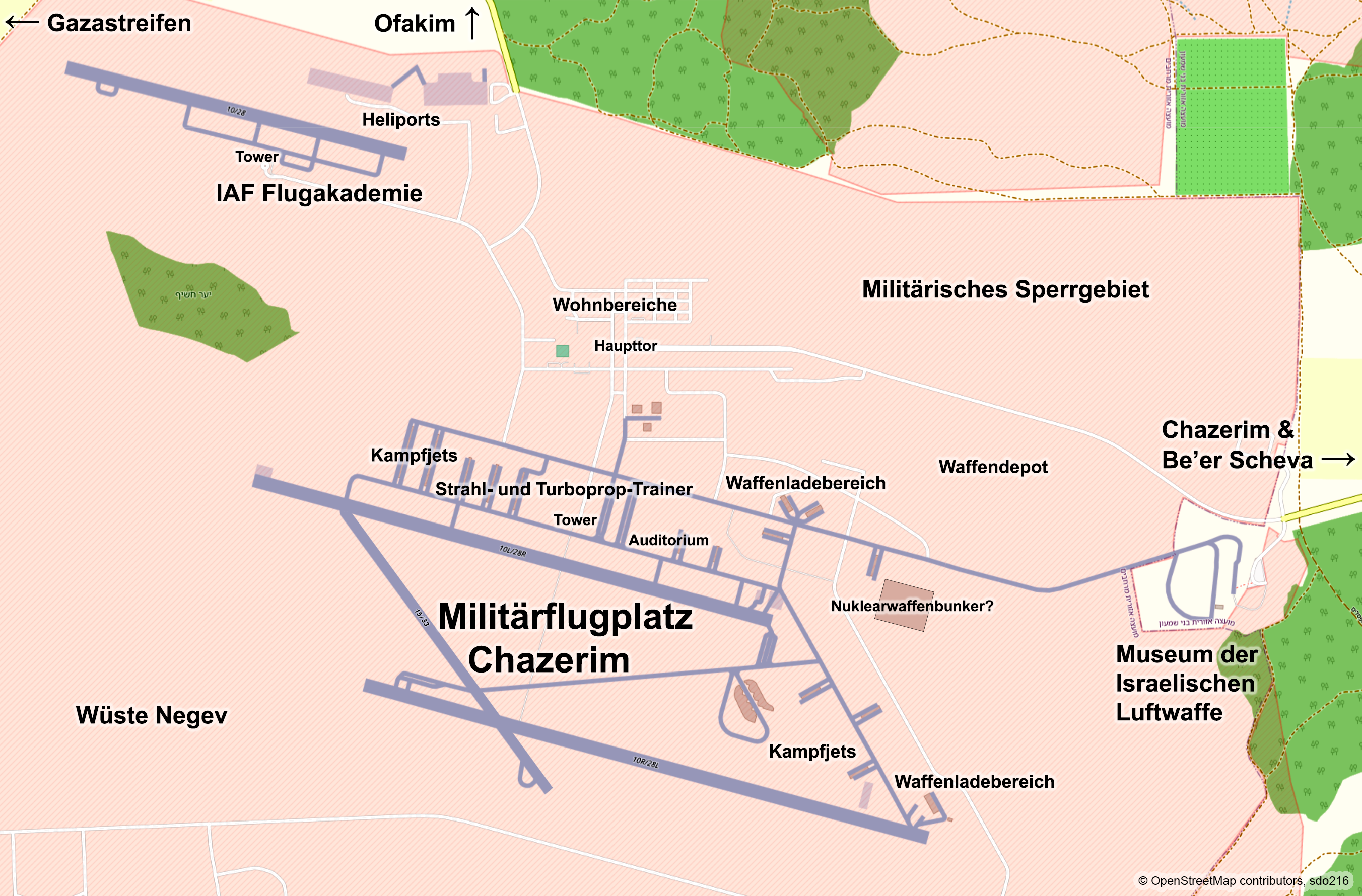
English: Map of Hatzerim Airbase with the northwestern area of the IAF Flight Academy and - east of the base, outside the security area - with the Israeli Air Force Museum
Deutsch: Karte des Militärflughafens Chazerim mit dem nordwestlichen Bereich der IAF-Flugakademie und - östlich der Basis, außerhalb des Sicherheitsbereiches - mit dem Israeli Air Force Museum |
|||
| Date | ||||
| Source | openstreetmap.org | |||
| Creator |
OpenStreetMap contributors, sdo216 OpenStreetMap contributors |
|||
| Permission (Reusing this file) |
OpenStreetMap data is available under the Open Database License (details). Standard style map tiles are licensed as ODbL Produced Works.
|
|||
| Georeferencing | If inappropriate please set warp_status = skip to hide. |
File history
Click on a date/time to view the file as it appeared at that time.
| Date/Time | Thumbnail | Dimensions | User | Comment | |
|---|---|---|---|---|---|
| current | 19:37, 18 March 2024 | | 2,704 × 1,780 (1.13 MB) | Sdo216 (talk | contribs) | Corrections |
| 13:41, 20 January 2024 |  | 2,704 × 1,780 (1.14 MB) | Sdo216 (talk | contribs) | Corrections | |
| 20:40, 8 January 2024 |  | 2,704 × 1,780 (1.13 MB) | Sdo216 (talk | contribs) | More details | |
| 14:24, 7 January 2024 |  | 2,704 × 1,780 (1.12 MB) | Sdo216 (talk | contribs) | Corrections | |
| 16:20, 29 December 2023 |  | 2,704 × 1,780 (1.1 MB) | Sdo216 (talk | contribs) | Correction | |
| 19:34, 28 December 2023 |  | 2,704 × 1,780 (1.1 MB) | Sdo216 (talk | contribs) | Nuclear warhead bunkers | |
| 15:18, 16 November 2023 |  | 2,704 × 1,780 (1.09 MB) | Sdo216 (talk | contribs) | Gaza & Negev | |
| 21:10, 13 October 2023 |  | 2,704 × 1,780 (1.06 MB) | Sdo216 (talk | contribs) | More details | |
| 07:16, 8 October 2023 |  | 2,704 × 1,780 (1.02 MB) | Sdo216 (talk | contribs) | Restricted military area | |
| 14:05, 7 October 2023 |  | 2,704 × 1,780 (1,021 KB) | Sdo216 (talk | contribs) | Richtung Ofakim eingezeichnet |
You cannot overwrite this file.
File usage on Commons
The following 10 pages use this file:
- User:Geagea/IDF/2023 December 28
- User:Geagea/IDF/2023 December 29
- User:Geagea/IDF/2023 November 16
- User:Geagea/IDF/2023 October 13
- User:Geagea/IDF/2023 October 6
- User:Geagea/IDF/2023 October 8
- User:Geagea/IDF/2024 January 20
- User:Geagea/IDF/2024 January 7
- User:Geagea/IDF/2024 January 8
- User:Geagea/IDF/2024 March 18
File usage on other wikis
The following other wikis use this file:
- Usage on de.wikipedia.org