File:Hausa language map.png
跳至導覽
跳至搜尋
預覽大小:474 × 600 像素。 其他解析度:190 × 240 像素 | 379 × 480 像素 | 607 × 768 像素 | 809 × 1,024 像素 | 1,618 × 2,048 像素 | 3,571 × 4,519 像素。
原始檔案 (3,571 × 4,519 像素,檔案大小:447 KB,MIME 類型:image/png)
說明
說明
添加單行說明來描述出檔案所代表的內容
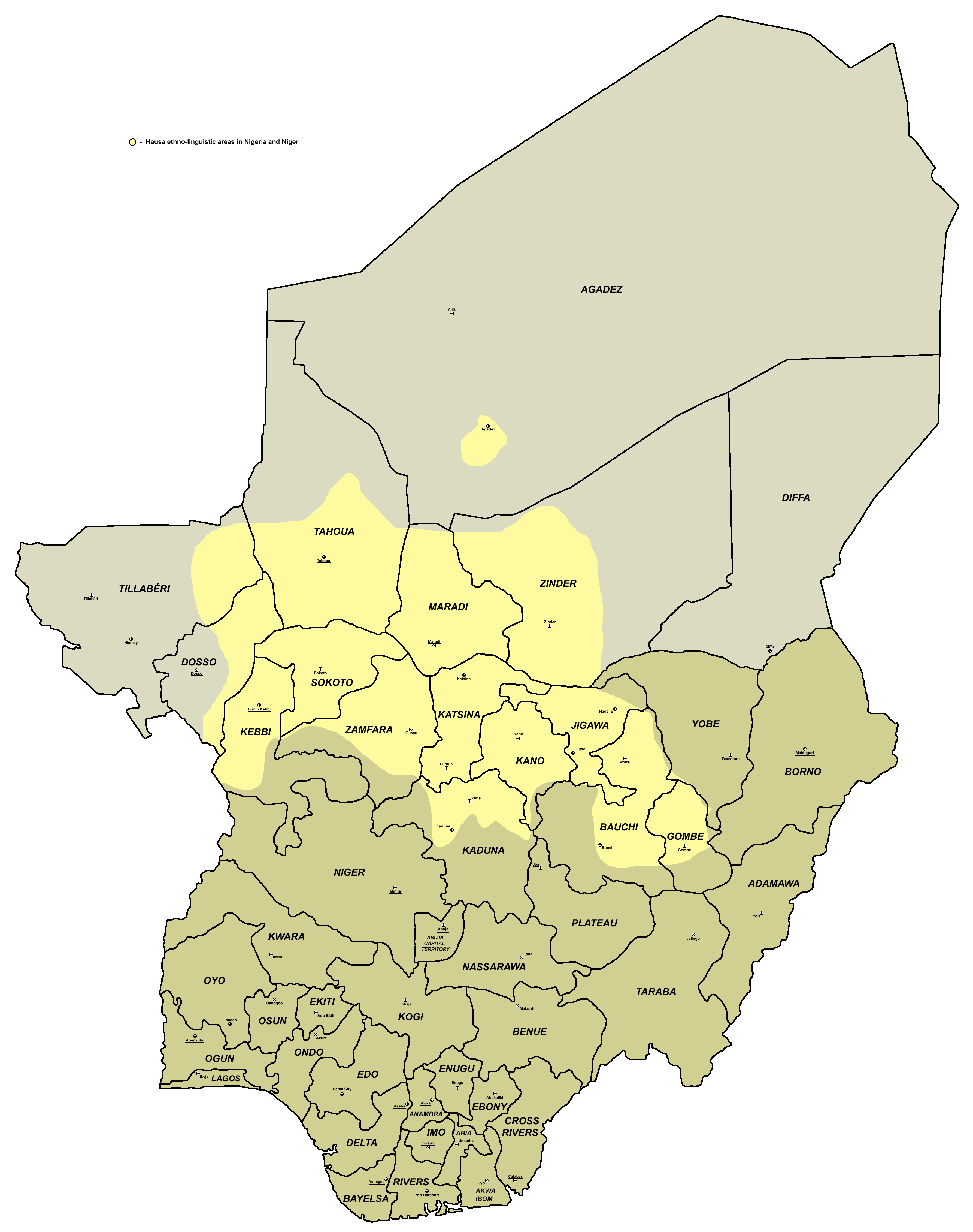
Hausa language distribution
摘要[編輯]
| 描述 |
English: This map showcasing an actual settlement of hausa tribe and hausa speakers within Nigeria and Niger , |
| 日期 | |
| 來源 |
本檔案衍生自:
|
| 作者 | Kwamikagami |
授權條款[編輯]
英文維基百科的Kwamikagami,此作品的版權所有人,決定用以下授權條款發佈本作品:

|
已授權您依據自由軟體基金會發行的無固定段落、封面文字和封底文字GNU自由文件授權條款1.2版或任意後續版本,對本檔進行複製、傳播和/或修改。該協議的副本列在GNU自由文件授權條款中。 |
此檔案採用創用CC 姓名標示-相同方式分享 3.0 未在地化版本授權條款。
姓名標示: 英文維基百科的Kwamikagami
- 您可以自由:
- 分享 – 複製、發佈和傳播本作品
- 重新修改 – 創作演繹作品
- 惟需遵照下列條件:
- 姓名標示 – 您必須指名出正確的製作者,和提供授權條款的連結,以及表示是否有對內容上做出變更。您可以用任何合理的方式來行動,但不得以任何方式表明授權條款是對您許可或是由您所使用。
- 相同方式分享 – 如果您利用本素材進行再混合、轉換或創作,您必須基於如同原先的相同或兼容的條款,來分布您的貢獻成品。
您可以選擇您需要的授權條款。
References[編輯]
- 1. Ethnic maps of Nigerian states from Nigeria's National Bureau of Statistics website: http://www.nigerianstat.gov.ng/maps.php archive copy at the Wayback Machine
- 2. Borders of Nigerian states (and locations of state capitals) are drawn according to the UN map of Nigeria: http://commons.wikimedia.org/wiki/File:Un-nigeria.png
- 3. Sizable cities in the part of Nigeria inhabited by Hausa people are selected in accordance with the info from World Gazetteer page for Nigeria: http://world-gazetteer.com/wg.php?x=&men=gadm&lng=en&des=wg&geo=-158&srt=npan&col=abcdefghinoq&msz=1500 archive copy at the Wayback Machine
- 4. Linguistic map of Niger from www.ethnologue.com: http://www.ethnologue.com/maps/ner_eth.jpg
- 5. Borders of provinces of Niger (and locations of provincial capitals) are drawn according to the UN map of Niger: http://commons.wikimedia.org/wiki/File:Un-niger.png
- 6. Sizable cities in Niger are selected in accordance with the info from World Gazetteer page for Niger: http://world-gazetteer.com/wg.php?x=&men=gcis&lng=en&des=wg&srt=npan&col=abcdefghinoq&msz=1500&geo=-156[失效連結]
- 7. Aditional source about presence of Hausa speakers in Agadez: http://www.saudiaramcoworld.com/issue/200301/agadez-sultanate.of.the.sahara.htm archive copy at the Wayback Machine
原始上傳日誌[編輯]
The original description page was here. All following user names refer to en.wikipedia.
- 2012-04-06 21:47 Kwamikagami 2413×3077× (972777 bytes) Uploading a self-made file using [[Wikipedia:File_Upload_Wizard|File Upload Wizard]]
檔案歷史
點選日期/時間以檢視該時間的檔案版本。
| 日期/時間 | 縮圖 | 尺寸 | 使用者 | 備註 | |
|---|---|---|---|---|---|
| 目前 | 2014年10月28日 (二) 18:36 | | 3,571 × 4,519(447 KB) | PANONIAN(留言 | 貢獻) | aesthetically improved version + more accurate legend description per used sources |
| 2013年4月14日 (日) 08:19 |  | 2,413 × 3,077(950 KB) | Dcirovic(留言 | 貢獻) | {{Information |Description={{en|Map of Hausa}} |Source=Transferred from [http://en.wikipedia.org en.wikipedia]<br/> (Original text : ''combined File:Afro asiatic peoples nigeria.png and File:Hausa language niger.png'') |Date={{Original upload date|2012... |
無法覆蓋此檔案。
檔案用途
下列3個頁面有用到此檔案:
全域檔案使用狀況
以下其他 wiki 使用了這個檔案:
- af.wikipedia.org 的使用狀況
- ar.wikipedia.org 的使用狀況
- arz.wikipedia.org 的使用狀況
- ast.wikipedia.org 的使用狀況
- azb.wikipedia.org 的使用狀況
- be.wikipedia.org 的使用狀況
- bg.wikipedia.org 的使用狀況
- bn.wikipedia.org 的使用狀況
- br.wikipedia.org 的使用狀況
- ca.wikipedia.org 的使用狀況
- ckb.wikipedia.org 的使用狀況
- cs.wikipedia.org 的使用狀況
- cy.wikipedia.org 的使用狀況
- dag.wikipedia.org 的使用狀況
- da.wikipedia.org 的使用狀況
- de.wikipedia.org 的使用狀況
- diq.wikipedia.org 的使用狀況
- el.wikipedia.org 的使用狀況
- en.wikipedia.org 的使用狀況
- eo.wikipedia.org 的使用狀況
- es.wikipedia.org 的使用狀況
- et.wikipedia.org 的使用狀況
- eu.wikipedia.org 的使用狀況
- fa.wikipedia.org 的使用狀況
- fi.wikipedia.org 的使用狀況
- fo.wikipedia.org 的使用狀況
- frr.wikipedia.org 的使用狀況
- fr.wikipedia.org 的使用狀況
- fy.wikipedia.org 的使用狀況
- ga.wikipedia.org 的使用狀況
- gl.wikipedia.org 的使用狀況
- ha.wikipedia.org 的使用狀況
檢視此檔案的更多全域使用狀況。