File:Hazel.gif
跳转到导航
跳转到搜索
没有更高的分辨率。
Hazel.gif (304 × 272像素,文件大小:30 KB,MIME类型:image/gif、0.2秒)
说明
说明
添加一行文字以描述该文件所表现的内容
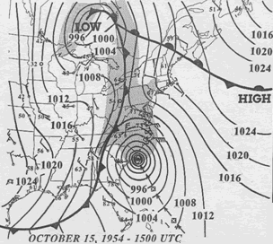
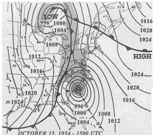
Weather map of the Eastern United States featuring Hurricane Hazel on October 15, 1954.
| 描述 | 15 UTC map of October 1954 showing Hurricane Hazel and the meteorological set-up. | |||
| 日期 | ||||
| 来源 | NOAA analysis created by Paul Kocin, of NOAA’s National Weather Service. It can be found at Environment Canada and at NOAA pages. This map is included in this article about Hazel by the Canadian Hurricane Center and this one by the National Weather Service Eastern Region Headquarters. | |||
| 作者 | NOAA | |||
| 授权 (二次使用本文件) |
|
文件历史
点击某个日期/时间查看对应时刻的文件。
| 日期/时间 | 缩略图 | 大小 | 用户 | 备注 | |
|---|---|---|---|---|---|
| 当前 | 2010年3月13日 (六) 16:32 | | 304 × 272(30 KB) | Maxim(留言 | 贡献) | removed border |
| 2007年4月2日 (一) 07:23 |  | 312 × 277(32 KB) | Pierre cb(留言 | 贡献) | {{Hurricane auto track map|type=Hurricane|name=Hazel (1954)|source=NHC}} H {{Information |Description= 15 UTC map of October 1954 showing Hurricane Hazel and the meteorological set-up. |Source= [http://www.atl.e |
您不可以覆盖此文件。
文件用途
以下页面使用本文件:
全域文件用途
以下其他wiki使用此文件:
- en.wikipedia.org上的用途
- eo.wikipedia.org上的用途
- es.wikipedia.org上的用途
- fa.wikipedia.org上的用途
- fr.wikipedia.org上的用途
- pt.wikipedia.org上的用途
- zh.wikipedia.org上的用途