File:Heavy Snow in Eastern China.jpg
ナビゲーションに移動
検索に移動

このプレビューのサイズ: 488 × 599 ピクセル。 その他の解像度: 195 × 240 ピクセル | 391 × 480 ピクセル | 626 × 768 ピクセル | 834 × 1,024 ピクセル | 1,669 × 2,048 ピクセル | 4,400 × 5,400 ピクセル。
元のファイル (4,400 × 5,400 ピクセル、ファイルサイズ: 5.47メガバイト、MIME タイプ: image/jpeg)
キャプション
キャプション
このファイルの内容を1行で記述してください
概要
[編集]| 解説 |
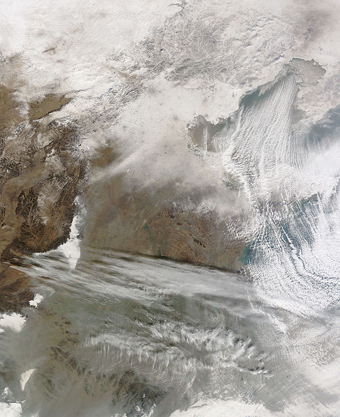
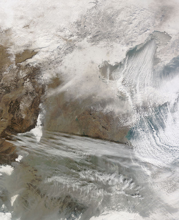
English: Snow cover encircles Bo Hai and extends to the north and west of that water body. Snow also covers Beijing, Tianjin, and a constellation of smaller settlements. The large cities leave big grey splotches on the blanket of snow, and the smaller cities make small grey dots. Snow caps the mountains north and west of Beijing, but the snow cover gradually fades south-west of Beijing and Tianjin. Cloud streets—clouds arranged in neat rows—similar to those observed over Hudson Bay and the Great Lakes float over Bo Hai. |
| 日付 | |
| 原典 | NASA Earth Observatory |
| 作者 | Jeff Schmaltz |
| その他のバージョン |
|

Image captured by the Moderate Resolution Imaging Spectroradiometer (MODIS) on NASA’s Terra satellite, courtesy of the MODIS Rapid Response Team, Goddard Space Flight Centre.
ライセンス
[編集]
| このファイルはアメリカ航空宇宙局(NASA)によって作成されたものです。NASAの著作権の方針では、特記事項が無い場合、NASAの資料はパブリックドメインとなります。 (詳しくはTemplate:PD-USGov、NASAの著作権の方針について(英語)又はジェット推進研究所(JPL)の画像使用に関するガイドライン(英語)をご覧ください。) |
||
 |
注意事項:
|
| 注釈 | この画像には注釈がついています: コモンズで注釈を見る |
ファイルの履歴
過去の版のファイルを表示するには、その版の日時をクリックしてください。
| 日付と時刻 | サムネイル | 寸法 | 利用者 | コメント | |
|---|---|---|---|---|---|
| 現在の版 | 2010年1月7日 (木) 11:56 | | 4,400 × 5,400 (5.47メガバイト) | Originalwana (トーク | 投稿記録) | {{Information |Description={{en|1=Snow cover encircles Bo Hai and extends to the north and west of that water body. Snow also covers Beijing, Tianjin, and a constellation of smaller settlements. The large cities leave big grey splotches on |
このファイルは上書きできません。
ファイルの使用状況
以下のページがこのファイルを使用しています:
グローバルなファイル使用状況
以下に挙げる他のウィキがこの画像を使っています:
- ar.wikipedia.org での使用状況
- en.wikipedia.org での使用状況
- fa.wikipedia.org での使用状況
- ja.wikipedia.org での使用状況
- uk.wikipedia.org での使用状況
- www.wikidata.org での使用状況
- zh.wikipedia.org での使用状況