File:Heavy Snow in Eastern China.jpg
跳转到导航
跳转到搜索

本预览的尺寸:488 × 599像素。 其他分辨率:195 × 240像素 | 391 × 480像素 | 626 × 768像素 | 834 × 1,024像素 | 1,669 × 2,048像素 | 4,400 × 5,400像素。
原始文件 (4,400 × 5,400像素,文件大小:5.47 MB,MIME类型:image/jpeg)
说明
说明
添加一行文字以描述该文件所表现的内容
摘要
[编辑]| 描述 |
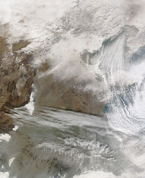
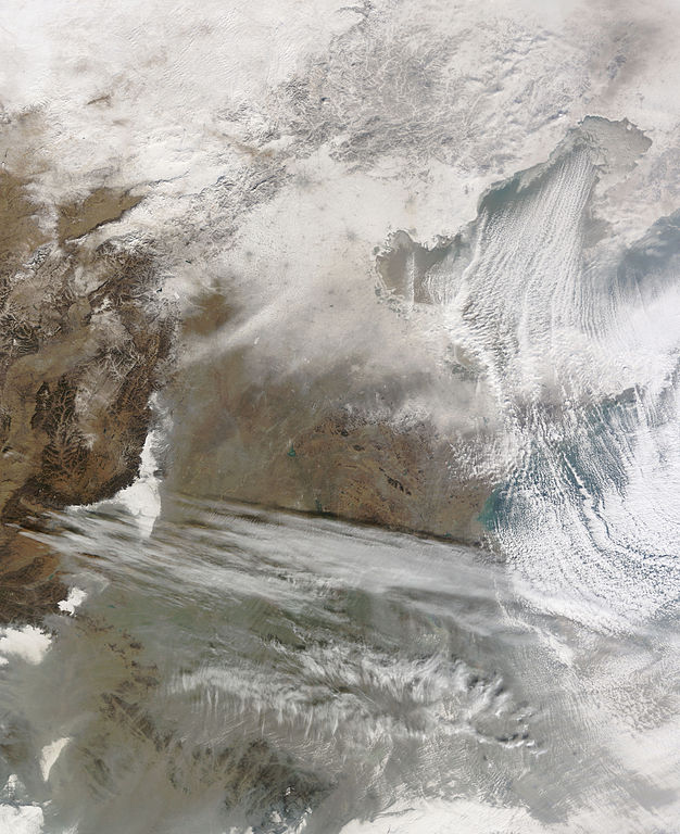
English: Snow cover encircles Bo Hai and extends to the north and west of that water body. Snow also covers Beijing, Tianjin, and a constellation of smaller settlements. The large cities leave big grey splotches on the blanket of snow, and the smaller cities make small grey dots. Snow caps the mountains north and west of Beijing, but the snow cover gradually fades south-west of Beijing and Tianjin. Cloud streets—clouds arranged in neat rows—similar to those observed over Hudson Bay and the Great Lakes float over Bo Hai. |
| 日期 | |
| 来源 | NASA Earth Observatory |
| 作者 | Jeff Schmaltz |
| 其他版本 |
|

Image captured by the Moderate Resolution Imaging Spectroradiometer (MODIS) on NASA’s Terra satellite, courtesy of the MODIS Rapid Response Team, Goddard Space Flight Centre.
许可协议
[编辑]
| 本文件完全由NASA创作,在美国属于公有领域。根据NASA的版权方针,NASA的材料除非另有声明否则不受版权保护。(参见Template:PD-USGov/zh、NASA版权方针页面或JPL图片使用方针。) | ||
 |
警告:
|
| 註解 | 該圖片含有註解:在維基媒體共享資源上查看註解 |
文件历史
点击某个日期/时间查看对应时刻的文件。
| 日期/时间 | 缩略图 | 大小 | 用户 | 备注 | |
|---|---|---|---|---|---|
| 当前 | 2010年1月7日 (四) 11:56 | | 4,400 × 5,400(5.47 MB) | Originalwana(留言 | 贡献) | {{Information |Description={{en|1=Snow cover encircles Bo Hai and extends to the north and west of that water body. Snow also covers Beijing, Tianjin, and a constellation of smaller settlements. The large cities leave big grey splotches on |
您不可以覆盖此文件。
文件用途
以下页面使用本文件:
全域文件用途
以下其他wiki使用此文件:
- ar.wikipedia.org上的用途
- en.wikipedia.org上的用途
- fa.wikipedia.org上的用途
- ja.wikipedia.org上的用途
- uk.wikipedia.org上的用途
- www.wikidata.org上的用途
- zh.wikipedia.org上的用途