File:Heinrich Kiepert, Galiläa (FL45585263 3927895).jpg
Jump to navigation
Jump to search
Size of this preview: 800 × 569 pixels. Other resolutions: 320 × 228 pixels | 640 × 455 pixels | 1,024 × 729 pixels | 1,280 × 911 pixels | 2,646 × 1,883 pixels.
Original file (2,646 × 1,883 pixels, file size: 1.87 MB, MIME type: image/jpeg)
Captions
Captions
Add a one-line explanation of what this file represents
Summary
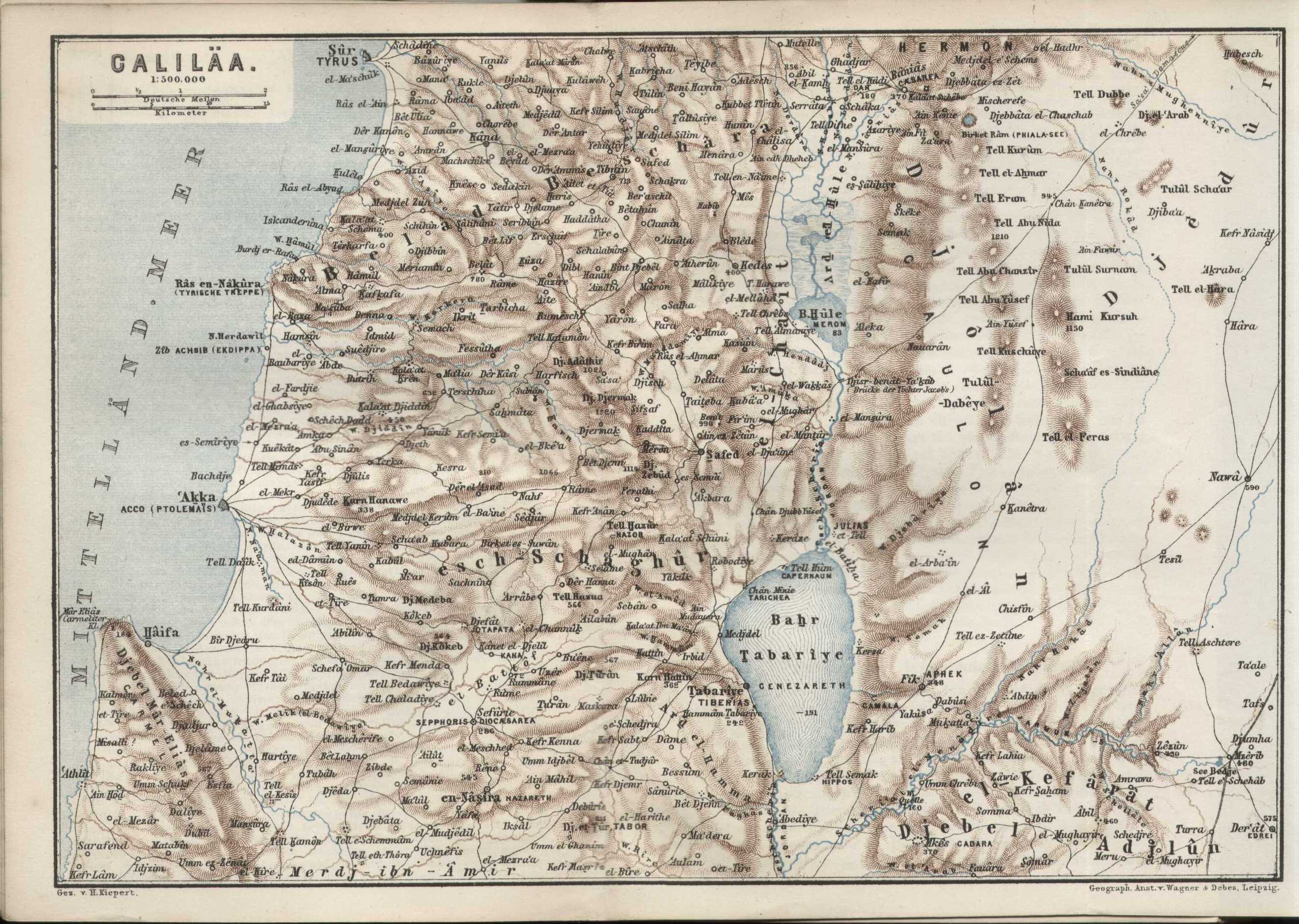
[edit]| Heinrich Kiepert: Galiläa
( |
||||||||||||||||||||||||
|---|---|---|---|---|---|---|---|---|---|---|---|---|---|---|---|---|---|---|---|---|---|---|---|---|
| Artist |
|
|||||||||||||||||||||||
| Title |
Galiläa |
|||||||||||||||||||||||
| Publisher |
Karl Baedeker |
|||||||||||||||||||||||
| Description |
Galiläa. Gez. v. H. Kiepert. |
|||||||||||||||||||||||
| Language | German | |||||||||||||||||||||||
| Publication date | 1880 | |||||||||||||||||||||||
| Medium | 1 online resource (1 map). | |||||||||||||||||||||||
| Collection |
|
|||||||||||||||||||||||
| Current location |
|
|||||||||||||||||||||||
| Place of publication | Leipzig | |||||||||||||||||||||||
| search Merhav catalog | Leipzig | |||||||||||||||||||||||
| Notes | Digital image of the original in Amir Cahanovitc Collection, Israel. ACC 2378-15.; Digital image received from donor.; From: Palästina und Syrien: Handbuch für reisende, herausgegeben von K. Baedeker. Mit 18 karten, 44 plänen, 1 panorama von Jerusalem und 10 ansichten. | |||||||||||||||||||||||
| scale | 1:500,000 cm | |||||||||||||||||||||||
| IE PID | IE45585261 | |||||||||||||||||||||||
| Rosetta filename | FL45585263 | |||||||||||||||||||||||
| NNL item ID (P3959) | 990039278950205171 | |||||||||||||||||||||||
| search Merhav catalog | German, Heinrich Kiepert | |||||||||||||||||||||||
| search Merhav catalog | Karl Baedeker | |||||||||||||||||||||||
| Source/Photographer |
|
|||||||||||||||||||||||
| Other versions | ||||||||||||||||||||||||
| Jpg / Tif version |
|
|||||||||||||||||||||||
Loescher_%26_btv1b8453164n_(cropped).jpg)

.jpg)

.jpg&action=edit§ion=1)
Licensing
[edit].jpg&action=edit§ion=2)
The copyright situation of this work is theoretically uncertain, because in the country of origin copyright lasts 70 years after the death of the author, and the date of the author's death is unknown. However, the date of creation of the work was over 120 years ago, and it is thus a reasonable assumption that the copyright has expired (see here for the community discussion). Do not use this template if the date of death of the author is known.
| |
| This file has been identified as being free of known restrictions under copyright law, including all related and neighboring rights. | |
File history
Click on a date/time to view the file as it appeared at that time.
| Date/Time | Thumbnail | Dimensions | User | Comment | |
|---|---|---|---|---|---|
| current | 19:58, 5 September 2023 | | 2,646 × 1,883 (1.87 MB) | Geagea (talk | contribs) | pattypan 22.03 |
You cannot overwrite this file.
File usage on Commons
The following page uses this file:
.jpg&oldid=798736200)