File:Heller, Leon, & Wilhelmi Karte von Yucatan 1847-1848 UTA.jpg
Jump to navigation
Jump to search

Size of this preview: 460 × 600 pixels. Other resolutions: 184 × 240 pixels | 368 × 480 pixels | 589 × 768 pixels | 785 × 1,024 pixels | 1,571 × 2,048 pixels | 2,761 × 3,600 pixels.
Original file (2,761 × 3,600 pixels, file size: 2.61 MB, MIME type: image/jpeg)
Captions
Captions
Add a one-line explanation of what this file represents
Summary[edit]
| Title |
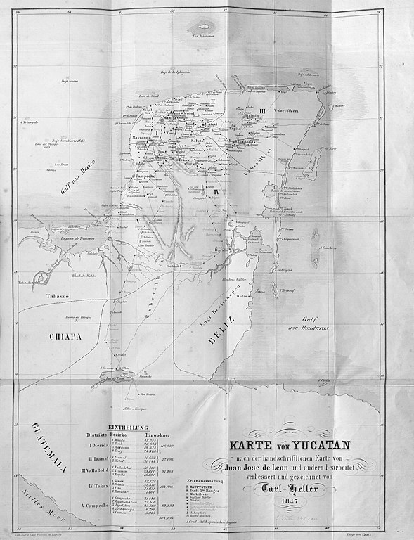
Deutsch: Karte von Yucatan nach der handschriftlichen Karte von Juan Jose de Leon und andern bearbeitet verbessert und gezeichnet von Carl Heller 1847 English: Map of Yucatan drawn and improved by Carl Heller 1847 and based upon the manuscript map by Juan Jose de Leon and others |
||||||||||||||||||||||||||
| Description |
English: The map includes cities, villages, haciendas, ranchos, ruins, anchorages, and roads in addition to other topographical details. Author and mapmaker Carl Bartolomeus Heller (1824-1880) was a young Austrian botanist and gentleman traveler who was in Mexico during the U.S. War with Mexico. His observations on Yucatan, Chiapas, and Tabasco were of particular importance, but his book was not published in an English translation until 2007. See Alone in Mexico: The Astonishing Travels of Karl Heller, 1845-1848, trans. and ed. by Terry Rugeley (Tuscaloosa: University of Alabama Press, 2007). |
||||||||||||||||||||||||||
| Date | between 1847 and 1848 | ||||||||||||||||||||||||||
| Source | UTA Libraries A Continent Divided | ||||||||||||||||||||||||||
| Creator |
Carl Heller Juan Jose de Leon Emil Wilhelmi |
||||||||||||||||||||||||||
| Credit line |
English: The University of Texas at Arlington Libraries Special Collections |
||||||||||||||||||||||||||
| Geotemporal data | |||||||||||||||||||||||||||
| Map location | Yucatán | ||||||||||||||||||||||||||
| Georeferencing | If inappropriate please set warp_status = skip to hide. | ||||||||||||||||||||||||||
| Bibliographic data | |||||||||||||||||||||||||||
| Publication |
Reisen in Mexiko in den Jahren 1845-1848 |
||||||||||||||||||||||||||
| Author |
Von Carl Bartholomaeus Heller |
||||||||||||||||||||||||||
| Place of publication | Leipzig | ||||||||||||||||||||||||||
| Publisher |
W. Engelmann |
||||||||||||||||||||||||||
| Printed by |
Emil Wilhelmi |
||||||||||||||||||||||||||
| Archival data | |||||||||||||||||||||||||||
| Collection |
|
||||||||||||||||||||||||||
Licensing[edit]

|
This file was provided to Wikimedia Commons by the University of Texas at Arlington Libraries as part of a cooperation project. The University of Texas at Arlington Libraries is part of the University of Texas at Arlington, a public research university located in Arlington, Texas.
|
This work is in the public domain in the United States because it was published (or registered with the U.S. Copyright Office) before January 1, 1929.
Public domain works must be out of copyright in both the United States and in the source country of the work in order to be hosted on the Commons. If the work is not a U.S. work, the file must have an additional copyright tag indicating the copyright status in the source country.
Note: This tag should not be used for sound recordings. |
File history
Click on a date/time to view the file as it appeared at that time.
| Date/Time | Thumbnail | Dimensions | User | Comment | |
|---|---|---|---|---|---|
| current | 16:51, 11 June 2021 | | 2,761 × 3,600 (2.61 MB) | Michael Barera (talk | contribs) | == {{int:filedesc}} == {{Map |title = '''''{{de|Karte von Yucatan nach der handschriftlichen Karte von Juan Jose de Leon und andern bearbeitet verbessert und gezeichnet von Carl Heller 1847}}''''' <br /> {{en|''Map of Yucatan drawn and improved by Carl Heller 1847 and based upon the manuscript map by Juan Jose de Leon and others''}} |description = {{en|The map includes cities, villages, haciendas, ranchos, ruins, anchorages, and roads in addition to other topographical det... |
You cannot overwrite this file.
File usage on Commons
The following page uses this file:
File usage on other wikis
The following other wikis use this file:
- Usage on de.wikipedia.org