File:Hendricks County Bridge 316 northern side.jpg
Jump to navigation
Jump to search

Size of this preview: 800 × 450 pixels. Other resolutions: 320 × 180 pixels | 640 × 360 pixels | 1,024 × 576 pixels | 1,280 × 720 pixels | 2,816 × 1,584 pixels.
Original file (2,816 × 1,584 pixels, file size: 2.54 MB, MIME type: image/jpeg)
Captions
Captions
Add a one-line explanation of what this file represents
|
This is an image of a place or building that is listed on the National Register of Historic Places in the United States of America. Its reference number is 3000140. |
| Camera location | | View this and other nearby images on: OpenStreetMap |
|---|
| Description |
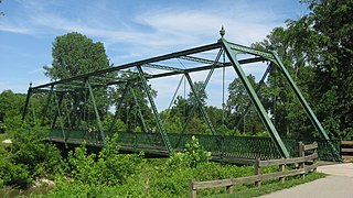
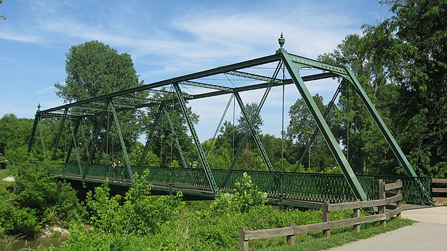
English: Northern side of the Hendricks County Bridge Number 316, which carries a trail over White Lick Creek in a city park on the southern side of Plainfield, Indiana, United States. Built in 1886, it is listed on the National Register of Historic Places. |
||
| Date | Taken on 12 June 2011 | ||
| Source | Own work | ||
| Author | Nyttend | ||
| Permission (Reusing this file) |
|
File history
Click on a date/time to view the file as it appeared at that time.
| Date/Time | Thumbnail | Dimensions | User | Comment | |
|---|---|---|---|---|---|
| current | 12:15, 16 June 2011 | | 2,816 × 1,584 (2.54 MB) | Nyttend (talk | contribs) | {{Location|39|41|47|N|86|24|7|W}} {{Information |Description={{en|Northern side of the {{w|Hendricks County Bridge Number 316}}, which carries a trail over White Lick Creek in a city park on the southern side of {{w|Plainfield, Indiana|Plainfield}}, {{w|I |
You cannot overwrite this file.
File usage on Commons
The following page uses this file:
File usage on other wikis
The following other wikis use this file:
- Usage on en.wikipedia.org
- Usage on www.wikidata.org