File:Herzog Stjepan Fort.jpg
From Wikimedia Commons, the free media repository
Jump to navigation
Jump to search
Size of this preview: 800 × 347 pixels. Other resolutions: 320 × 139 pixels | 922 × 400 pixels.
Original file (922 × 400 pixels, file size: 201 KB, MIME type: image/jpeg)
File information
Structured data
Captions
Summary
[edit]Camera location | 43° 12′ 07.03″ N, 17° 33′ 26.32″ E | View this and other nearby images on: OpenStreetMap | 43.201954; 17.557311 |
---|
DescriptionHerzog Stjepan Fort.jpg |
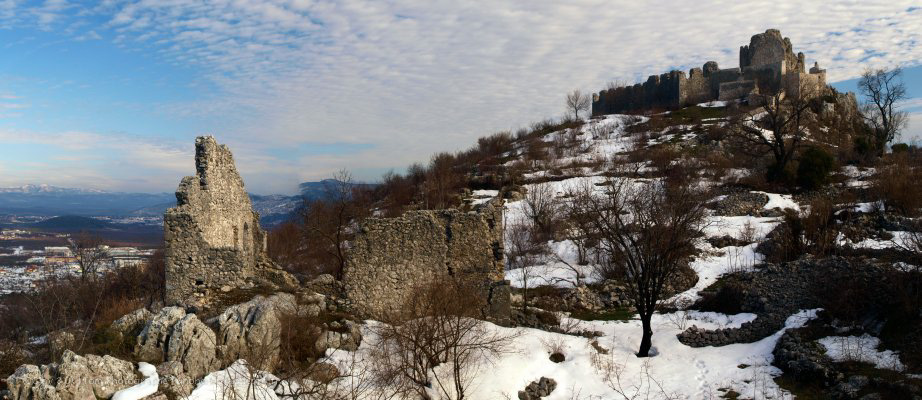
English: Ljubuški (Herzegovina) Herzog Stjepan castle (in ruins) |
Date | |
Source | Own work |
Author | Tomphotographe |
Licensing
[edit]I, the copyright holder of this work, hereby publish it under the following license:
This file is licensed under the Creative Commons Attribution 3.0 Unported license.
- You are free:
- to share – to copy, distribute and transmit the work
- to remix – to adapt the work
- Under the following conditions:
- attribution – You must give appropriate credit, provide a link to the license, and indicate if changes were made. You may do so in any reasonable manner, but not in any way that suggests the licensor endorses you or your use.
File history
Click on a date/time to view the file as it appeared at that time.
Date/Time | Thumbnail | Dimensions | User | Comment | |
---|---|---|---|---|---|
current | 15:51, 22 July 2012 | 922 × 400 (201 KB) | Tomphotographe (talk | contribs) |
You cannot overwrite this file.
File usage on Commons
The following page uses this file:
File usage on other wikis
The following other wikis use this file:
- Usage on ar.wikipedia.org
- Usage on be.wikipedia.org
- Usage on ca.wikipedia.org
- Usage on ceb.wikipedia.org
- Usage on cs.wikipedia.org
- Usage on en.wikipedia.org
- Usage on eo.wikipedia.org
- Usage on es.wikipedia.org
- Usage on fi.wikipedia.org
- Usage on hy.wikipedia.org
- Usage on ka.wikipedia.org
- Usage on no.wikipedia.org
- Usage on pl.wikipedia.org
- Usage on ro.wikipedia.org
- Usage on ru.wikipedia.org
- Usage on sr.wikipedia.org
- Usage on www.wikidata.org
Metadata
This file contains additional information such as Exif metadata which may have been added by the digital camera, scanner, or software program used to create or digitize it. If the file has been modified from its original state, some details such as the timestamp may not fully reflect those of the original file. The timestamp is only as accurate as the clock in the camera, and it may be completely wrong.
Image title |
|
---|---|
Camera manufacturer | OLYMPUS IMAGING CORP. |
Camera model | E-450 |
Author | Tom Photographe |
Copyright holder |
|
Exposure time | 1/160 sec (0.00625) |
F-number | f/7.1 |
ISO speed rating | 100 |
Date and time of data generation | 16:23, 25 February 2012 |
Lens focal length | 23 mm |
User comments |
|
Latitude | 43° 12′ 7.03″ N |
Longitude | 17° 33′ 26.32″ E |
Altitude | 324 meters above sea level |
Credit/Provider | http://www.unphotographepro.fr |
Source | http://www.unphotographepro.fr |
Usage terms |
|
Horizontal resolution | 240 dpi |
Vertical resolution | 240 dpi |
Software used | Adobe Photoshop CS3 Windows |
File change date and time | 20:54, 20 July 2012 |
Exposure Program | Creative program (biased toward depth of field) |
Exif version | 2.21 |
Date and time of digitizing | 16:23, 25 February 2012 |
APEX shutter speed | 7.321928 |
APEX aperture | 5.655638 |
APEX exposure bias | 0 |
Maximum land aperture | 3.61328125 APEX (f/3.5) |
Metering mode | Pattern |
Light source | Unknown |
Flash | Flash did not fire, auto mode |
File source | Digital still camera |
Custom image processing | Normal process |
Exposure mode | Auto exposure |
White balance | Auto white balance |
Digital zoom ratio | 1 |
Scene capture type | Standard |
Scene control | None |
Contrast | Normal |
Saturation | Normal |
Sharpness | Normal |
GPS time (atomic clock) | 15:23 |
Reference for direction of image | True direction |
Direction of image | 146.84 |
Geodetic survey data used | WGS-84 |
Latitude destination | 43° 12′ 4.92″ N |
Longitude of destination | 17° 33′ 28.21″ E |
GPS date | 25 February 2012 |
GPS tag version | 0.0.2.2 |
Color space | sRGB |
Supported Flashpix version | 1 |
Image width | 922 px |
Image height | 400 px |
Y and C positioning | Co-sited |
Width | 922 px |
Height | 400 px |
Date metadata was last modified | 18:16, 20 July 2012 |
Rating (out of 5) | 5 |
Contact information | [at unphotographepro.fr contact [at] unphotographepro.fr]
http://www.unphotographepro.fr
|
Keywords |
|
Code for country shown | BIH |
Sublocation of city shown | Mostarska Vrata |
Country shown | Bosnia and Herzegovina |
Province or state shown | Federation of Bosnia and Herzego |
IIM version | 2 |