File:Hiddensee asv2022-08 img16 Vitte Stolperstein Loewenthal.jpg
Une page de Wikimedia Commons, la médiathèque libre.
Aller à la navigation
Aller à la recherche
- Fichier
- Historique du fichier
- Utilisations locales du fichier
- Utilisations du fichier sur d’autres wikis
- Métadonnées
Taille de cet aperçu : 600 × 600 pixels. Autres résolutions : 240 × 240 pixels | 480 × 480 pixels | 768 × 768 pixels | 1 024 × 1 024 pixels | 2 048 × 2 048 pixels | 4 026 × 4 026 pixels.
Fichier d’origine (4 026 × 4 026 pixels, taille du fichier : 11,37 Mio, type MIME : image/jpeg)
Informations sur le fichier
Données structurées
Légendes
Description
[modifier]DescriptionHiddensee asv2022-08 img16 Vitte Stolperstein Loewenthal.jpg |
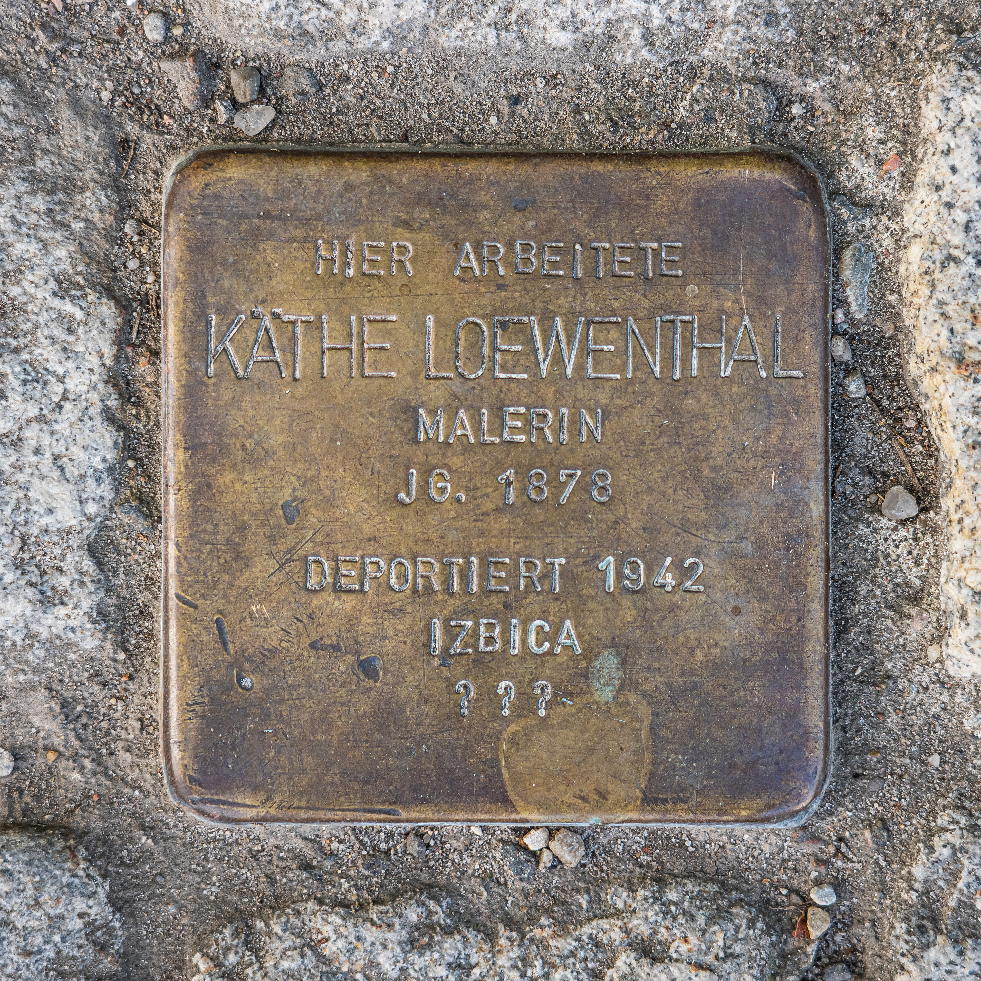
English: Stolperstein memorial to Käthe Loewenthal on Hiddensee island, Mecklenburg-Western Pomerania, Germany
Deutsch: Stolperstein Käthe Loewenthal auf der Insel Hiddensee, Mecklenburg-Vorpommern, Deutschland
Русский: Мемориал-камень преткновения Кете Лёвенталь на острове Хиддензее, Мекленбург-Передняя Померания, Германия |
Date | |
Source | Travail personnel |
Auteur | A.Savin |
Autorisation (Réutilisation de ce fichier) |
Free Art License. Free usage of the photo; usually no need to ask for approval. Just attribute the author: «A.Savin, Wikipedia»; if you have questions — Telegram , or e-mail to wikiphotospace@gmail.com .Лицензия Свободное искусство. Использование фотографии бесплатно; согласование обычно не требуется. Просто укажите в качестве автора: «А.Савин, Википедия»; если есть вопрос — телеграм , или эл.почта на wikiphotospace@gmail.com .Lizenz Freie Kunst. Nutzung des Fotos kostenlos; Anfrage in der Regel nicht erforderlich. Kennzeichnen Sie einfach als Autor: «A.Savin, Wikipedia»; falls Sie Fragen haben — Telegram , oder E-Mail an wikiphotospace@gmail.com .
Thank you. |
Lieu de la prise de vue | 54° 33′ 47″ N, 13° 06′ 10,8″ E | Voir cet endroit et d’autres images sur : OpenStreetMap | 54.563056; 13.103000 |
---|
Conditions d’utilisation
[modifier]Copyleft : cette œuvre d’art est libre ; vous pouvez la redistribuer ou la modifier selon les termes de la licence Art Libre. Vous trouverez un exemplaire de cette licence sur le site Copyleft Attitude ainsi que sur d’autres sites. http://artlibre.org/licence/lal/enFALFree Art Licensefalsetrue |
Historique du fichier
Cliquer sur une date et heure pour voir le fichier tel qu'il était à ce moment-là.
Date et heure | Vignette | Dimensions | Utilisateur | Commentaire | |
---|---|---|---|---|---|
actuel | 9 janvier 2023 à 02:56 | 4 026 × 4 026 (11,37 Mio) | A.Savin (d | contributions) | {{User:A.Savin/F|L=0 |Description= {{en|Stolperstein memorial to Käthe Loewenthal on Hiddensee island, Mecklenburg-Western Pomerania, Germany}} {{de|Stolperstein Käthe Loewenthal auf der Insel Hiddensee, Mecklenburg-Vorpommern, Deutschland}} {{ru|Мемориал-камень преткновения Кете Лёвенталь на острове Хиддензее, Мекленбург-Передняя Померания, Германия}} |Year=2022 |Country=Germany |Month=08 |Day=25}} {{Location}} Category:Taken with Sony ILCE-7RM3 [[Category:Taken with Sony FE 24-105mm F4... |
Vous ne pouvez pas remplacer ce fichier.
Utilisations locales du fichier
La page suivante utilise ce fichier :
Utilisations du fichier sur d’autres wikis
Les autres wikis suivants utilisent ce fichier :
- Utilisation sur de.wikipedia.org
- Utilisation sur fr.wikipedia.org
- Utilisation sur www.wikidata.org
Métadonnées
Ce fichier contient des informations supplémentaires, probablement ajoutées par l'appareil photo numérique ou le numériseur utilisé pour le créer.
Si le fichier a été modifié depuis son état original, certains détails peuvent ne pas refléter entièrement l'image modifiée.
Fabricant de l’appareil photo | SONY |
---|---|
Modèle de l’appareil photo | ILCE-7RM3 |
Auteur | A.Savin |
Détenteur des droits d’auteur |
|
Durée d’exposition | 1/100 s (0,01 s) |
Ouverture focale | f / 4 |
Sensibilité ISO (vitesse d’obturation) | 50 |
Date et heure de génération des données | 25 août 2022 à 15:08 |
Longueur focale de la lentille | 88 mm |
Latitude | 54° 33′ 47,03″ N |
Longitude | 13° 6′ 10,96″ E |
Largeur | 7 952 px |
Hauteur | 5 304 px |
Bits par composante |
|
Composition des pixels | RVB |
Orientation | Normale |
Nombre de composantes | 3 |
Résolution horizontale | 300 pt/po |
Résolution verticale | 300 pt/po |
Logiciel utilisé | Adobe Photoshop CC 2019 (Windows) |
Date de modification du fichier | 4 janvier 2023 à 04:53 |
Programme d’exposition | Réglage manuel |
Version d’EXIF | 2.31 |
Date et heure de la numérisation | 25 août 2022 à 15:08 |
Vitesse d’obturation APEX | 6,643856 |
Ouverture APEX | 4 |
Luminance APEX | 6,42734375 |
Biais de compensation d’exposition APEX | 0 |
Ouverture maximale interne de la lentille | 4 APEX (f / 4) |
Mode de mesure | Motif géométrique |
Source de lumière | Inconnue |
Flash | Flash non déclenché, suppression du flash obligatoire |
Espace colorimétrique | sRGB |
Résolution horizontale du plan focal | 2 164,432800293 |
Résolution verticale du plan focal | 2 164,432800293 |
Unité de résolution du plan focal | 3 |
Source du fichier | Appareil photo numérique |
Type de scène | Image photographiée directement |
Rendu d’image personnalisé | Procédé normal |
Mode d’exposition | Exposition manuelle |
Balance des blancs | Balance des blancs automatique |
Taux de zoom numérique | 1 |
Longueur focale pour un film 35 mm | 88 mm |
Type de capture de la scène | Standard |
Contraste | Normal |
Saturation | Normale |
Netteté | Normale |
Heure GPS (horloge atomique) | 13:09 |
État du récepteur | Mesure en cours |
Mode de mesure | Mesure en 2 dimensions |
Système géodésique utilisé | WGS-84 |
Date du GPS | 25 août 2022 |
Correction différentielle du GPS | 0 |
Version de la balise GPS | 0.0.3.2 |
Lentille utilisée | FE 24-105mm F4 G OSS |
Date de la dernière modification des métadonnées | 4 janvier 2023 à 05:53 |
Identifiant unique du document original | DAD07255B8853465728D8E824B625E5E |
Version d’IIM | 4 |