File:High Speed Railroad Map of Europe.svg
ナビゲーションに移動
検索に移動

この SVG ファイルのこの PNG プレビューのサイズ: 746 × 599 ピクセル. その他の解像度: 299 × 240 ピクセル | 598 × 480 ピクセル | 956 × 768 ピクセル | 1,275 × 1,024 ピクセル | 2,549 × 2,048 ピクセル | 1,038 × 834 ピクセル。
元のファイル (SVG ファイル、1,038 × 834 ピクセル、ファイルサイズ: 1.68メガバイト)
キャプション
キャプション
このファイルの内容を1行で記述してください
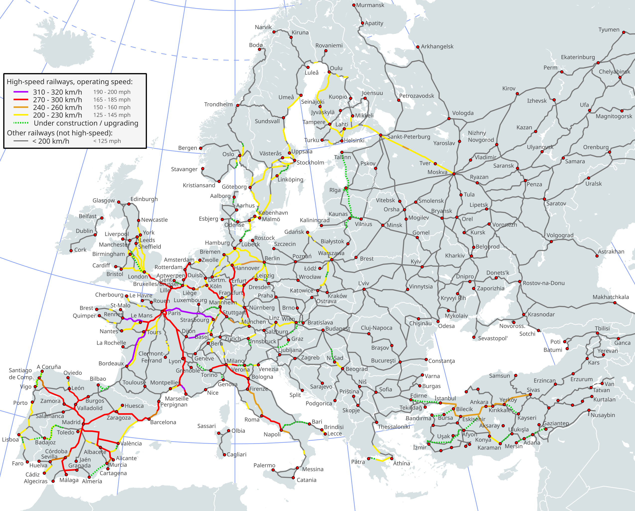
Map of high-speed rail lines in Europe
概要[編集]

|
このファイルは、最新の情報を受けて更新される可能性があります。 新しい更新が反映されることなく、特定の版のファイルを使用したい場合は、必要な版を別のファイルとしてアップロードしてください。 |
| 解説 |
English (en): High-speed railway network in Europe1
310-320km/h (192-198mph) 270-300km/h (167-186mph) 240-260km/h (149-162mph) 200-230km/h (124-142mph) Under construction/Upgrading (dashed lines) Less than 200km/h (124mph) (if dashed line: important international line where there is however currently no passenger traffic)
1 The map depicts the actual operational high-speed instead of the designed one which may be higher.
Deutsch (de): Europäisches Hochgeschwindigkeitsbahnnetz1
310-320 km/h 270-300 km/h 240-260 km/h 200-230 km/h Im Bau/Ausbau (Strichlinien) Weniger als 200 km/h
1 Die Karte zeigt die Betriebshöchstgeschwindigkeit anstatt der für die Linie ausgelegten Höchstgeschwindigkeit, welche höher sein kann.
español (es): Red de ferrocarriles de alta velocidad europea1
310-320 km/h 270-300 km/h 240-260 km/h 200-230 km/h En construcción (líneas rayadas) Menos de 200 km/h
1 El mapa sólo incluye la máxima velocidad comercial de las vías.
suomi (fi): Euroopan suurnopeusrataverkosto1
310-320 km/h 270-300 km/h 240-260 km/h 200-230 km/h Rakenteilla (katkoviivalliset) Alle 200 km/h
1 Kartassa on esitetty toteutuvien operointinopeuksien sijasta teoreettiset ratojen huippunopeudet, jotka saattavat olla todellisia liikennöintinopeuksia korkeampia.
français (fr): Réseau ferré européen à grande vitesse1
310-320 km/h 270-300 km/h 240-260 km/h 200-230 km/h En construction (pointillés) Moins de 200 km/h (si pointillés: ligne internationale d'importance mais actuellement sans trafic voyageurs)
1 Seules les vitesses pratiquées sur les lignes sont prises en compte, pas les vitesses supportées ou théoriques.
Türkçe (tr): Avrupa'da yüksek hızlı demiryolu ağı1
310-320km/s 270-300km/s 240-260km/s 200-230km/s İnşa halinde (çizgili yerler) 200km/s'den az
1 Harita teorik hız yerine fiili işletme hızını yansıtmaktadır. Teorik hız fiili hızdan daha yüksek olabilir.
polski (pl): Mapa linii wysokich prędkości w Europie1
310-320km/h 270-300km/h 240-260km/h 200-230km/h W budowie/modernizacji Mniej niż 200km/h (ważne linie międzynarodowe z czasowo zawieszonym ruchem zaznaczono linią przerywaną)
1 Mapa przedstawia rzeczywistą maksymalną prędkość eksploatacyjną zamiast prędkości projektowanej, która może być wyższa.
Ελληνικά (el): Το σιδηροδρομικό δίκτυο υπερταχείας στην Ευρώπη
310-320 km/h 270-300 km/h 240-260 km/h 200-230 km/h υπό κατασκευή (διακεκομμένη γραμμή) κάτω από 200 km/h
italiano (it): Rete ferroviaria ad alta velocità europea1
310-320 km/h 270-300 km/h 240-260 km/h 200-230 km/h In construzione (linee tratteggiate) Meno di 200 km/h
1 La mappa considera la velocità operativa massima, non la velocità massima nominale.
Nederlands (nl): Het Europese netwerk van hogesnelheidslijnen1
310-320 km/u 270-300 km/u 240-260 km/u 200-230 km/u In aanbouw (stippellijnen) Minder dan 200 km/u
1 De kaart geeft de feitelijke operationele snelheid aan in plaats van de ontworpen snelheid, die soms hoger ligt.
čeština (cs): Vysokorychlostní železniční síť v Evropě1
310-320km/h 270-300km/h 240-260km/h 200-230km/h Ve výstavbě (přerušovaná čára) Méně než 200km/h
1 Mapa zobrazuje aktuální provozní rychlost místo projektované, která může být vyšší.
slovenčina (sk): Vysokorychlostná železničná sieť v Európe1
310-320km/h 270-300km/h 240-260km/h 200-230km/h Vo výstavbe (prerušovaná čiara) Menej ako 200km/h (prerušovaná čiara: dôležitá medzinárodná trať v súčasnosti bez osobnej dopravy)
1 Mapa zobrazuje aktuálnu prevádzkovú rýchlosť namiesto projektovanej, ktorá môže byť vyššia
русский (ru): Высокоскоростная железнодорожная сеть в Европе1
310—320 км/ч (192—198 миль в час) 270—300 км/ч (167—186 миль в час) 240—260 км/ч (149—162 миль в час) 200—230 км/ч (124—142 миль в час) Строится / Модернизируется (пунктирные линии) Менее 200 км / ч (124 миль в час) (пунктирная линия: важная международная линия, где в настоящее время нет пассажирских перевозок)
1 На карте отражена фактическая рабочая скорость, а не запланированная, которая может быть выше.
日本語 (ja): 2017年のヨーロッパの高速鉄道ネットワーク1
310-320km/h (192-198mph) 270-300km/h (167-186mph) 240-260km/h (149-162mph) 200-230km/h (124-142mph) 建設中/改良工事中 (破線) 200km/h未満 (124mph) (破線の場合: 旅客営業を行わない主要国際路線)
1 この地図は実際に運行されている高速鉄道を元に描かれている。
|
| 日付 | 2014-12-25, last revision 2023-04 |
| 原典 |
このファイルの派生元: High Speed Railroad Map of Europe 2015.svg
|
| 作者 |
Original PNG : User:Bernese media, User:BIL 2011 SVG version: User:Akwa and others (see the history & the source file) |
| その他のバージョン |
|
| SVG 開発 |


ライセンス[編集]
このファイルはクリエイティブ・コモンズ 表示-継承 3.0 非移植ライセンスのもとに利用を許諾されています。
- あなたは以下の条件に従う場合に限り、自由に
- 共有 – 本作品を複製、頒布、展示、実演できます。
- 再構成 – 二次的著作物を作成できます。
- あなたの従うべき条件は以下の通りです。
- 表示 – あなたは適切なクレジットを表示し、ライセンスへのリンクを提供し、変更があったらその旨を示さなければなりません。これらは合理的であればどのような方法で行っても構いませんが、許諾者があなたやあなたの利用行為を支持していると示唆するような方法は除きます。
- 継承 – もしあなたがこの作品をリミックスしたり、改変したり、加工した場合には、あなたはあなたの貢献部分を元の作品とこれと同一または互換性があるライセンスの下に頒布しなければなりません。
ファイルの履歴
過去の版のファイルを表示するには、その版の日時をクリックしてください。
| 日付と時刻 | サムネイル | 寸法 | 利用者 | コメント | |
|---|---|---|---|---|---|
| 現在の版 | 2024年2月2日 (金) 11:02 | | 1,038 × 834 (1.68メガバイト) | TheMarcus13 (トーク | 投稿記録) | Spain: Variante de Pajares in Operation, Kopenhagen-Ringsted in Operation (at the moment only IC/EC Kopenhagen-Hamburg can run at up to 200km/h there), passenger service between Lithuania and Latvia resumed, Classic low speed lines with long distnace service from Miranda di Ebro to Bilbao and Irún exist, Crimea bridge |
| 2023年9月18日 (月) 16:17 |  | 1,038 × 834 (1.6メガバイト) | Carfois (トーク | 投稿記録) | Spain: removed the grey line Évora-Elvas (there is no such existing line!) | Added Badajoz city point | Badajoz–Plasencia is curently operated at 200km/h and is being upgraded (electrification) | |
| 2023年7月18日 (火) 16:56 |  | 1,038 × 834 (1.68メガバイト) | TheMarcus13 (トーク | 投稿記録) | Corrected wrong speed limits (design speed instead of operating speed) of my previous upload | |
| 2023年7月18日 (火) 16:47 |  | 1,038 × 834 (1.68メガバイト) | TheMarcus13 (トーク | 投稿記録) | Updated high-speed lines in Sweden (Botniabanan, nya haparandabanan), Norway (Follobanen Oslo-Ski) and Portugal/Spain (Lisbon-Evora-Badajoz-Madrid) | |
| 2023年6月18日 (日) 19:29 |  | 1,038 × 834 (1.67メガバイト) | Jklamo (トーク | 投稿記録) | Greece corrected (only some sections are 200 km/h), Catania - Palermo added (ongoing modernisation) | |
| 2023年5月16日 (火) 12:05 |  | 1,038 × 834 (1.67メガバイト) | Emturan (トーク | 投稿記録) | For the Ankara-Afyon-Usak-İzmir high-speed railway, the route at the Afyon-İzmir section has been corrected. The Turgutlu-Manisa-İzmir section is an upgrade. For the rest, a new two-lane line is under construction. Usak City has added. Aksaray City has added. (A new high-speed line between Ulukışla-Aksaray has been planned and started. An upgrade between Ulukışla-Yenice will connect Mersin-Adana-Gaziantep high-speed line to the rest of the high-speed network.) | |
| 2023年4月28日 (金) 13:50 |  | 1,038 × 834 (1.59メガバイト) | Carfois (トーク | 投稿記録) | Germany: the 60km-long Wendlingen–Ulm high-speed railway (250 km/h) entered in service in December 2022 | |
| 2023年4月27日 (木) 22:55 |  | 1,038 × 834 (1.59メガバイト) | Carfois (トーク | 投稿記録) | Spain: corrected some speeds (including on Madrid-Zaragoza, as there is no more service operating at 310 km/h in Spain since 2016) | |
| 2023年4月26日 (水) 20:34 |  | 1,038 × 834 (1.67メガバイト) | Emturan (トーク | 投稿記録) | Ankara-Kirikkale-YerKöy-Yozgat-Sivas High Speed Line opened to revenue service. | |
| 2023年4月26日 (水) 13:45 |  | 1,038 × 834 (1.59メガバイト) | Carfois (トーク | 投稿記録) | Sweden & Finland: removed dots on the sections Luleå-Haparanda and Kemi–Tornio since there is now passenger traffic on them. | Spain: corrected speed on Sevilla-Cadix (one part is at 140/160 km/h) / added the Algeciras city point |
このファイルは上書きできません。
ファイルの使用状況
このファイルへは 100 を超える数のページで使用されています。 以下の一覧ではこのファイルを使用している最初の 100 ページのみを表示しています。 完全な一覧も参照してください。
- High speed trains
- Railway lines
- User:Chumwa/OgreBot/Potential transport maps/2016 August 1-10
- User:Chumwa/OgreBot/Potential transport maps/2016 August 11-20
- User:Chumwa/OgreBot/Potential transport maps/2016 July 1-10
- User:Chumwa/OgreBot/Potential transport maps/2017 December 1-10
- User:Chumwa/OgreBot/Potential transport maps/2017 December 11-20
- User:Chumwa/OgreBot/Potential transport maps/2017 July 1-10
- User:Chumwa/OgreBot/Potential transport maps/2017 July 11-20
- User:Chumwa/OgreBot/Potential transport maps/2017 July 21-31
- User:Chumwa/OgreBot/Potential transport maps/2017 June 1-10
- User:Chumwa/OgreBot/Potential transport maps/2017 June 11-20
- User:Chumwa/OgreBot/Potential transport maps/2017 March 1-10
- User:Chumwa/OgreBot/Potential transport maps/2017 March 21-31
- User:Chumwa/OgreBot/Potential transport maps/2017 May 11-20
- User:Chumwa/OgreBot/Potential transport maps/2017 May 21-31
- User:Chumwa/OgreBot/Potential transport maps/2018 December 1-10
- User:Chumwa/OgreBot/Potential transport maps/2018 January 21-31
- User:Chumwa/OgreBot/Potential transport maps/2018 September 21-30
- User:Chumwa/OgreBot/Public transport information/2014 December 21-31
- User:Chumwa/OgreBot/Public transport information/2016 August 1-10
- User:Chumwa/OgreBot/Public transport information/2016 August 11-20
- User:Chumwa/OgreBot/Public transport information/2016 July 1-10
- User:Chumwa/OgreBot/Public transport information/2017 December 1-10
- User:Chumwa/OgreBot/Public transport information/2017 December 11-20
- User:Chumwa/OgreBot/Public transport information/2017 July 1-10
- User:Chumwa/OgreBot/Public transport information/2017 July 11-20
- User:Chumwa/OgreBot/Public transport information/2017 July 21-31
- User:Chumwa/OgreBot/Public transport information/2017 June 1-10
- User:Chumwa/OgreBot/Public transport information/2017 June 11-20
- User:Chumwa/OgreBot/Public transport information/2017 March 1-10
- User:Chumwa/OgreBot/Public transport information/2017 March 21-31
- User:Chumwa/OgreBot/Public transport information/2017 May 11-20
- User:Chumwa/OgreBot/Public transport information/2017 May 21-31
- User:Chumwa/OgreBot/Public transport information/2018 December 1-10
- User:Chumwa/OgreBot/Public transport information/2018 January 21-31
- User:Chumwa/OgreBot/Public transport information/2018 September 21-30
- User:Chumwa/OgreBot/Transport Maps/2014 December 21-31
- User:Chumwa/OgreBot/Transport Maps/2016 August 1-10
- User:Chumwa/OgreBot/Transport Maps/2016 August 11-20
- User:Chumwa/OgreBot/Transport Maps/2016 July 1-10
- User:Chumwa/OgreBot/Transport Maps/2017 December 1-10
- User:Chumwa/OgreBot/Transport Maps/2017 December 11-20
- User:Chumwa/OgreBot/Transport Maps/2017 July 1-10
- User:Chumwa/OgreBot/Transport Maps/2017 July 11-20
- User:Chumwa/OgreBot/Transport Maps/2017 July 21-31
- User:Chumwa/OgreBot/Transport Maps/2017 June 1-10
- User:Chumwa/OgreBot/Transport Maps/2017 June 11-20
- User:Chumwa/OgreBot/Transport Maps/2017 March 1-10
- User:Chumwa/OgreBot/Transport Maps/2017 March 21-31
- User:Chumwa/OgreBot/Transport Maps/2017 May 11-20
- User:Chumwa/OgreBot/Transport Maps/2017 May 21-31
- User:Chumwa/OgreBot/Transport Maps/2018 December 1-10
- User:Chumwa/OgreBot/Transport Maps/2018 January 21-31
- User:Chumwa/OgreBot/Transport Maps/2018 September 21-30
- User:Chumwa/OgreBot/Travel and communication maps/2016 August 1-10
- User:Chumwa/OgreBot/Travel and communication maps/2016 August 11-20
- User:Chumwa/OgreBot/Travel and communication maps/2016 July 1-10
- User:Chumwa/OgreBot/Travel and communication maps/2017 December 1-10
- User:Chumwa/OgreBot/Travel and communication maps/2017 December 11-20
- User:Chumwa/OgreBot/Travel and communication maps/2017 July 1-10
- User:Chumwa/OgreBot/Travel and communication maps/2017 July 11-20
- User:Chumwa/OgreBot/Travel and communication maps/2017 July 21-31
- User:Chumwa/OgreBot/Travel and communication maps/2017 June 1-10
- User:Chumwa/OgreBot/Travel and communication maps/2017 June 11-20
- User:Chumwa/OgreBot/Travel and communication maps/2017 March 1-10
- User:Chumwa/OgreBot/Travel and communication maps/2017 March 21-31
- User:Chumwa/OgreBot/Travel and communication maps/2017 May 11-20
- User:Chumwa/OgreBot/Travel and communication maps/2017 May 21-31
- User:Chumwa/OgreBot/Travel and communication maps/2018 December 1-10
- User:Chumwa/OgreBot/Travel and communication maps/2018 January 21-31
- User:Chumwa/OgreBot/Travel and communication maps/2018 September 21-30
- User:Frettiebot/Galleries/Jklamo/2016/8
- User:Hoff1980/Rail transport in France/2014 December 21-31
- User:Liesel/Rail transport/2014 December 21-31
- User:Mattbuck/Railways/2014 December 21-31
- User:Mattbuck/Railways/2016 August 1-10
- User:Mattbuck/Railways/2016 August 11-20
- User:Mattbuck/Railways/2016 July 1-10
- User:Mattbuck/Railways/2017 December 1-10
- User:Mattbuck/Railways/2017 December 11-20
- User:Mattbuck/Railways/2017 July 1-10
- User:Mattbuck/Railways/2017 July 11-20
- User:Mattbuck/Railways/2017 July 21-31
- User:Mattbuck/Railways/2017 June 1-10
- User:Mattbuck/Railways/2017 June 11-20
- User:Mattbuck/Railways/2017 March 1-10
- User:Mattbuck/Railways/2017 March 21-31
- User:Mattbuck/Railways/2017 May 11-20
- User:Mattbuck/Railways/2017 May 21-31
- User:Mattbuck/Railways/2018 December
- User:Mattbuck/Railways/2018 January 21-31
- User:Mattbuck/Railways/2018 September
- User:Nordlicht8/Rail Germany/2014 December 21-31
- User:Nordlicht8/Rail Germany/2016 August 1-10
- User:Nordlicht8/Rail Germany/2016 August 11-20
- User:Nordlicht8/Rail Germany/2016 July 1-10
- Commons:Structured data/Get involved/Feedback requests/Properties for Commons
- File:High Speed Railroad Map of Europe 2015.svg
- File:High Speed Railroad Map of Europe 2016.svg
このファイルへのリンク元を更にを表示する。
グローバルなファイル使用状況
以下に挙げる他のウィキがこの画像を使っています:
- ar.wikipedia.org での使用状況
- ast.wikipedia.org での使用状況
- ca.wikipedia.org での使用状況
- cs.wikipedia.org での使用状況
- da.wikipedia.org での使用状況
- de.wikipedia.org での使用状況
- de.wikivoyage.org での使用状況
- el.wikipedia.org での使用状況
- en.wikipedia.org での使用状況
- en.wikivoyage.org での使用状況
- eo.wikipedia.org での使用状況
- es.wikipedia.org での使用状況
- et.wikipedia.org での使用状況
- eu.wikipedia.org での使用状況
- fi.wikipedia.org での使用状況
- fr.wikipedia.org での使用状況
- Ligne à grande vitesse
- Route européenne
- Réseau transeuropéen de transport
- Autoroute de la mer
- Grande vitesse ferroviaire
- Liste des lignes à grande vitesse
- Liste des lignes à grande vitesse en France
- Allegro (train)
- Agence exécutive européenne pour le climat, les infrastructures et l’environnement
- Corridor Scandinavie-Méditerranée
- Corridor Orient/Méditerranée orientale
- Corridor Rhin-Danube
- Corridor Mer du Nord-Baltique
- Corridor Mer du Nord-Méditerranée
- Modèle:Palette Réseau transeuropéen de transport (RTE-T)
- Réseaux transeuropéens
- Corridor méditerranéen
このファイルのグローバル使用状況を表示する。