File:HighwayMapKansai(150dpi).png
Jump to navigation
Jump to search

Size of this preview: 800 × 566 pixels. Other resolutions: 320 × 226 pixels | 640 × 452 pixels | 1,024 × 724 pixels | 1,280 × 905 pixels | 1,754 × 1,240 pixels.
Original file (1,754 × 1,240 pixels, file size: 395 KB, MIME type: image/png)
Captions
Captions
Add a one-line explanation of what this file represents
| Description |
日本語: 自動車専用道路路線図(関西) |
| Date | 初版作成日:2006-09-27 |
| Source | |
| Author | ja:User:Ritsuka |
| Permission (Reusing this file) |
GFDL, CC-BY-SA-3.0 |
| Other versions |
PDF版: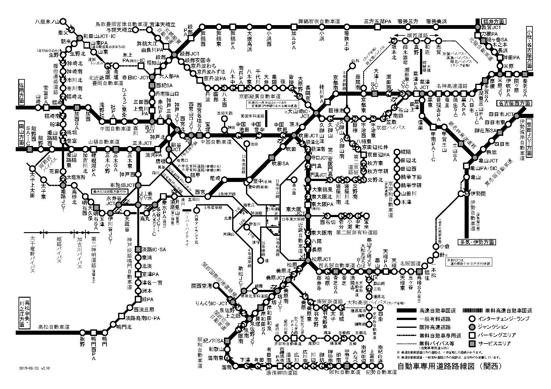 |
I, the copyright holder of this work, hereby publish it under the following licenses:

|
Permission is granted to copy, distribute and/or modify this document under the terms of the GNU Free Documentation License, Version 1.2 or any later version published by the Free Software Foundation; with no Invariant Sections, no Front-Cover Texts, and no Back-Cover Texts. A copy of the license is included in the section entitled GNU Free Documentation License. |
This file is licensed under the Creative Commons Attribution-Share Alike 3.0 Unported license.
- You are free:
- to share – to copy, distribute and transmit the work
- to remix – to adapt the work
- Under the following conditions:
- attribution – You must give appropriate credit, provide a link to the license, and indicate if changes were made. You may do so in any reasonable manner, but not in any way that suggests the licensor endorses you or your use.
- share alike – If you remix, transform, or build upon the material, you must distribute your contributions under the same or compatible license as the original.
You may select the license of your choice.
File history
Click on a date/time to view the file as it appeared at that time.
.png&dir=prev)
.png&offset=20080229072548)
.png&offset=&limit=20)
.png&offset=&limit=50)
.png&offset=&limit=100)
.png&offset=&limit=250)
.png&offset=&limit=500)
| Date/Time | Thumbnail | Dimensions | User | Comment | |
|---|---|---|---|---|---|
| current | 17:01, 22 August 2015 | | 1,754 × 1,240 (395 KB) | Ritsuka (talk | contribs) | 京都縦貫道全通、紀勢自動車道(新直轄区間)南紀田辺~南紀白浜開通、京奈和道延伸などを反映 |
| 14:39, 20 July 2014 |  | 1,754 × 1,240 (384 KB) | Ritsuka (talk | contribs) | 舞鶴若狭自動車道全通による変更、京奈和自動車道一部区間開業などを反映 | |
| 18:27, 22 October 2013 |  | 1,754 × 1,240 (361 KB) | Ritsuka (talk | contribs) | 秦荘PAの改名(湖東三山PA)・SIC新設に伴なう変更と、その他微調整 | |
| 07:12, 21 April 2013 |  | 1,754 × 1,240 (351 KB) | Ritsuka (talk | contribs) | 京都縦貫道大山崎─沓掛開通に伴なう変更。その他新設ICなどの変更点を反映。 | |
| 08:31, 24 March 2010 |  | 1,754 × 1,240 (336 KB) | Ritsuka (talk | contribs) | 湖西道路和迩インターのフルインターチェンジ化を反映 | |
| 07:29, 20 March 2010 |  | 1,754 × 1,240 (336 KB) | Ritsuka (talk | contribs) | 第二京阪道路延伸(枚方東~門真)に対応 | |
| 14:19, 28 March 2009 |  | 1,754 × 1,240 (326 KB) | Ritsuka (talk | contribs) | 直通不可の方面について記載(西宮山口JCT・名谷JCT)、志賀バイパス追加、甲南IC追加 | |
| 14:50, 12 January 2009 |  | 1,754 × 1,240 (325 KB) | Ritsuka (talk | contribs) | ||
| 13:01, 3 March 2008 |  | 1,754 × 1,240 (312 KB) | Ritsuka (talk | contribs) | ||
| 07:25, 29 February 2008 |  | 1,754 × 1,240 (314 KB) | Ritsuka (talk | contribs) |
You cannot overwrite this file.
File usage on Commons
There are no pages that use this file.
.png&oldid=689451137)