File:HighwaysMapPoland.svg
Aller à la navigation
Aller à la recherche

Taille de cet aperçu PNG pour ce fichier SVG : 643 × 599 pixels. Autres résolutions : 258 × 240 pixels | 515 × 480 pixels | 824 × 768 pixels | 1 099 × 1 024 pixels | 2 198 × 2 048 pixels | 776 × 723 pixels.
Fichier d’origine (Fichier SVG, nominalement de 776 × 723 pixels, taille : 359 kio)
Légendes
Légendes
Ajoutez en une ligne la description de ce que représente ce fichier
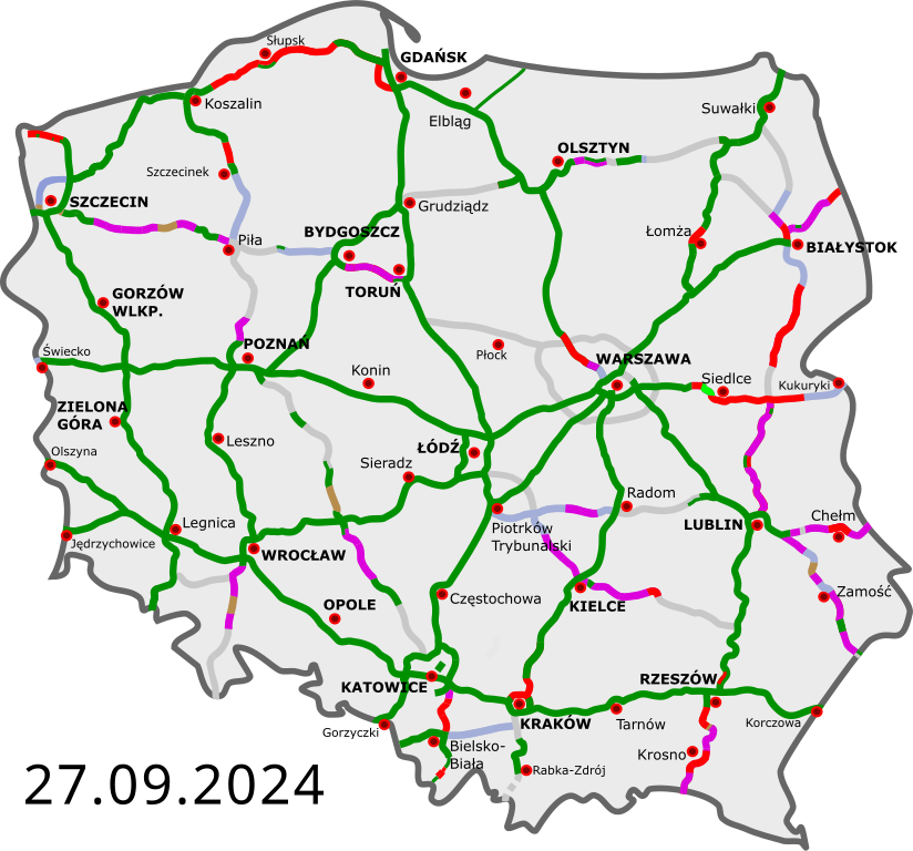
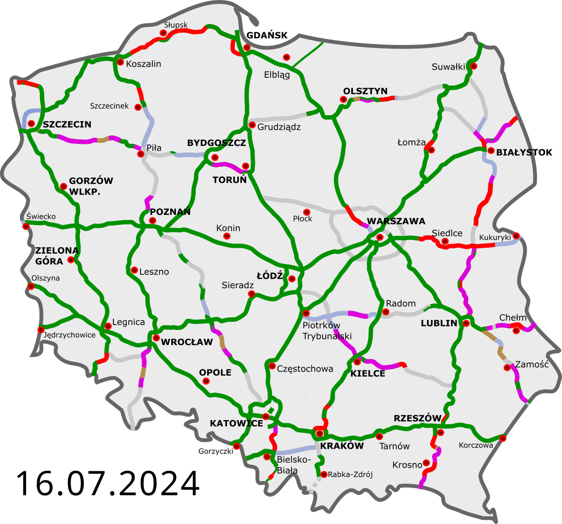
Map of Polish highways with progress of construction
Description[modifier]
| Description |
Polski: Polskie autostrady i drogi ekspresowe:
istniejące przejezdne (na zasadzie tymczasowej organizacji ruchu) w budowie umowa „projektuj i buduj”; etap projektowania w przetargu wydana decyzja środowiskowa planowane English: Polish freeways:
Completed Opened, some works continue Construction Design-build contract (design phase) Tender Environmental permit issued Planned Deutsch: polnische Autobahnen und Schnellstraßen:
fertiggestellt geöffnet, einige Arbeiten gehen weiter im Bau Entwurfs- und Bauvertrag, Entwurfsphase in der Ausschreibung Umweltverträglichkeitsprüfung geplant Čeština: Polské dálnice a rychlostní silnice:
v provozu ve stavbě plánované Esperanto: Polaj aŭtovojoj kaj rapidvojoj:
kompletigitaj malfermitaj, kelkaj laboroj daŭras konstruataj skizo kaj konstrukontrakto, projektfazo ofertataj al konstrufirmaoj planitaj Español: Autopistas y autovias polacas:
abiertas en construcción en proyecto Français : Les autoroutes polonaises:
existantes en construction en projet Magyar: Lengyelország autópályái:
kész szakasz épülő szakasz tervezett szakasz Italiano: Autostrade polacche: aperte al traffico in costruzione progettate |
||
| Date | |||
| Source | |||
| Auteur |
|
||
| Autres versions | Œuvres dérivées de ce fichier : Historia budowy autostrad i dróg ekspresowych.gif | ||
| SVG information | Le code de ce fichier SVG n'est pas valide en raison d'une erreur. Cette carte SVG utilise du texte encapsulé qui peut être traduit facilement à l'aide d'un éditeur de texte.
|
Conditions d’utilisation[modifier]
Moi, en tant que détenteur des droits d’auteur sur cette œuvre, je la publie sous les licences suivantes :
Ce fichier est disponible selon les termes de la licence Creative Commons Attribution 3.0 Non transposée.
- Vous êtes libre :
- de partager – de copier, distribuer et transmettre cette œuvre
- d’adapter – de modifier cette œuvre
- Sous les conditions suivantes :
- paternité – Vous devez donner les informations appropriées concernant l'auteur, fournir un lien vers la licence et indiquer si des modifications ont été faites. Vous pouvez faire cela par tout moyen raisonnable, mais en aucune façon suggérant que l’auteur vous soutient ou approuve l’utilisation que vous en faites.
Vous pouvez choisir l’une de ces licences.
Journal des téléversements d’origine[modifier]
This image is a derivative work of the following images:
- DocelowyUkladDrog.svg licensed with Cc-by-3.0, Cc-by-3.0
- 2009-08-30T16:41:32Z Sliwers 784x723 (155471 Bytes) Darker color.
- 2009-08-30T16:40:18Z Sliwers 784x723 (155471 Bytes) Cropped.
- 2009-08-30T16:36:58Z Sliwers 1073x790 (154212 Bytes) {{Information |Description={{en|1=Map of the planned free- and expressway network in Poland.}} {{pl|1=Docelowy układ autostrad i dróg ekspresowych w Polsce.}} {{de|1=Das Autobahn- und Schnellstraßennetz Polens, geplanter E
Téléversé avec derivativeFX
Historique du fichier
Cliquer sur une date et heure pour voir le fichier tel qu'il était à ce moment-là.
| Date et heure | Vignette | Dimensions | Utilisateur | Commentaire | |
|---|---|---|---|---|---|
| actuel | 14 mai 2024 à 11:53 | | 776 × 723 (359 kio) | Kirt93 (d | contributions) | Update of S16 & S19 near Białystok |
| 14 mai 2024 à 11:53 |  | 776 × 723 (359 kio) | Kirt93 (d | contributions) | Update of S16 & S19 near Białystok | |
| 13 mai 2024 à 20:11 |  | 776 × 723 (359 kio) | Kirt93 (d | contributions) | Fix rendering issues with S1 (and change date, as no other changes have happened) | |
| 26 avril 2024 à 18:08 |  | 776 × 723 (360 kio) | Docxent (d | contributions) | umowa na projekt i budowę odcinka S11 Gotartów - Olesno. | |
| 19 avril 2024 à 13:14 |  | 776 × 723 (359 kio) | Docxent (d | contributions) | wydanie ZRID dla budowy drugiej jezdni obwodnicy Kocka i Woli Skromowskiej (droga S19) | |
| 17 avril 2024 à 18:35 |  | 776 × 723 (359 kio) | Docxent (d | contributions) | umowa na proj. i budowę drugiej jezdni obw. Kępna w ciągu drogi S11 | |
| 16 avril 2024 à 17:00 |  | 776 × 723 (359 kio) | Docxent (d | contributions) | ZRID dla rozbudowy odcinka S19 Sokołów Małopolski Płn. - Jasionka | |
| 28 mars 2024 à 13:17 |  | 776 × 723 (359 kio) | Docxent (d | contributions) | umowa na proj. i budowę S11 Kępno - Siemianice | |
| 28 mars 2024 à 12:43 |  | 776 × 723 (359 kio) | Docxent (d | contributions) | Podpisanie umowy na zaprojektowanie i wybudowanie odc. S74 Cedzyna - Łagów | |
| 23 mars 2024 à 22:47 |  | 776 × 723 (359 kio) | Docxent (d | contributions) | S7 Lesznowola stała org. Ruchu |
Vous ne pouvez pas remplacer ce fichier.
Utilisations locales du fichier
Plus de 100 pages utilisent ce fichier. La liste suivante affiche seulement les 100 premières pages qui utilisent ce fichier. Une liste complète est disponible.
- User:Chumwa/OgreBot/Potential transport maps/2016 August 21-31
- User:Chumwa/OgreBot/Potential transport maps/2016 December 21-31
- User:Chumwa/OgreBot/Potential transport maps/2016 January 21-31
- User:Chumwa/OgreBot/Potential transport maps/2016 July 1-10
- User:Chumwa/OgreBot/Potential transport maps/2016 July 21-31
- User:Chumwa/OgreBot/Potential transport maps/2018 January 11-20
- User:Chumwa/OgreBot/Potential transport maps/2018 January 21-31
- User:Chumwa/OgreBot/Potential transport maps/2018 November 1-10
- User:Chumwa/OgreBot/Potential transport maps/2018 October 11-20
- User:Chumwa/OgreBot/Potential transport maps/2018 October 21-31
- User:Chumwa/OgreBot/Potential transport maps/2019 April 11-20
- User:Chumwa/OgreBot/Potential transport maps/2019 August 1-10
- User:Chumwa/OgreBot/Potential transport maps/2019 December 11-20
- User:Chumwa/OgreBot/Potential transport maps/2019 December 21-31
- User:Chumwa/OgreBot/Potential transport maps/2019 July 1-10
- User:Chumwa/OgreBot/Potential transport maps/2019 June 1-10
- User:Chumwa/OgreBot/Potential transport maps/2019 June 11-20
- User:Chumwa/OgreBot/Potential transport maps/2019 May 1-10
- User:Chumwa/OgreBot/Potential transport maps/2019 May 21-31
- User:Chumwa/OgreBot/Potential transport maps/2019 November 11-20
- User:Chumwa/OgreBot/Potential transport maps/2019 October 1-10
- User:Chumwa/OgreBot/Potential transport maps/2019 October 11-20
- User:Chumwa/OgreBot/Potential transport maps/2019 September 1-10
- User:Chumwa/OgreBot/Potential transport maps/2019 September 11-20
- User:Chumwa/OgreBot/Potential transport maps/2019 September 21-30
- User:Chumwa/OgreBot/Transport Maps/2015 December 21-31
- User:Chumwa/OgreBot/Transport Maps/2015 July 1-10
- User:Chumwa/OgreBot/Transport Maps/2015 November 1-10
- User:Chumwa/OgreBot/Transport Maps/2015 October 11-20
- User:Chumwa/OgreBot/Transport Maps/2016 August 21-31
- User:Chumwa/OgreBot/Transport Maps/2016 December 21-31
- User:Chumwa/OgreBot/Transport Maps/2016 January 21-31
- User:Chumwa/OgreBot/Transport Maps/2016 July 1-10
- User:Chumwa/OgreBot/Transport Maps/2016 July 21-31
- User:Chumwa/OgreBot/Transport Maps/2018 January 11-20
- User:Chumwa/OgreBot/Transport Maps/2018 January 21-31
- User:Chumwa/OgreBot/Transport Maps/2018 November 1-10
- User:Chumwa/OgreBot/Transport Maps/2018 October 11-20
- User:Chumwa/OgreBot/Transport Maps/2018 October 21-31
- User:Chumwa/OgreBot/Transport Maps/2019 April 11-20
- User:Chumwa/OgreBot/Transport Maps/2019 August 1-10
- User:Chumwa/OgreBot/Transport Maps/2019 December 11-20
- User:Chumwa/OgreBot/Transport Maps/2019 December 21-31
- User:Chumwa/OgreBot/Transport Maps/2019 July 1-10
- User:Chumwa/OgreBot/Transport Maps/2019 June 1-10
- User:Chumwa/OgreBot/Transport Maps/2019 June 11-20
- User:Chumwa/OgreBot/Transport Maps/2019 May 1-10
- User:Chumwa/OgreBot/Transport Maps/2019 May 21-31
- User:Chumwa/OgreBot/Transport Maps/2019 November 11-20
- User:Chumwa/OgreBot/Transport Maps/2019 October 1-10
- User:Chumwa/OgreBot/Transport Maps/2019 October 11-20
- User:Chumwa/OgreBot/Transport Maps/2019 September 1-10
- User:Chumwa/OgreBot/Transport Maps/2019 September 11-20
- User:Chumwa/OgreBot/Transport Maps/2019 September 21-30
- User:Chumwa/OgreBot/Transport Maps/2020 April 21-30
- User:Chumwa/OgreBot/Transport Maps/2020 December 1-10
- User:Chumwa/OgreBot/Transport Maps/2020 December 11-20
- User:Chumwa/OgreBot/Transport Maps/2020 December 21-31
- User:Chumwa/OgreBot/Transport Maps/2020 March 11-20
- User:Chumwa/OgreBot/Transport Maps/2020 May 11-20
- User:Chumwa/OgreBot/Transport Maps/2020 November 1-10
- User:Chumwa/OgreBot/Transport Maps/2020 November 11-20
- User:Chumwa/OgreBot/Transport Maps/2020 November 21-30
- User:Chumwa/OgreBot/Transport Maps/2020 October 11-20
- User:Chumwa/OgreBot/Transport Maps/2020 October 21-31
- User:Chumwa/OgreBot/Travel and communication maps/2016 August 21-31
- User:Chumwa/OgreBot/Travel and communication maps/2016 December 21-31
- User:Chumwa/OgreBot/Travel and communication maps/2016 January 21-31
- User:Chumwa/OgreBot/Travel and communication maps/2016 July 1-10
- User:Chumwa/OgreBot/Travel and communication maps/2016 July 21-31
- User:Chumwa/OgreBot/Travel and communication maps/2018 January 11-20
- User:Chumwa/OgreBot/Travel and communication maps/2018 January 21-31
- User:Chumwa/OgreBot/Travel and communication maps/2018 November 1-10
- User:Chumwa/OgreBot/Travel and communication maps/2018 October 11-20
- User:Chumwa/OgreBot/Travel and communication maps/2018 October 21-31
- User:Chumwa/OgreBot/Travel and communication maps/2019 April 11-20
- User:Chumwa/OgreBot/Travel and communication maps/2019 August 1-10
- User:Chumwa/OgreBot/Travel and communication maps/2019 December 11-20
- User:Chumwa/OgreBot/Travel and communication maps/2019 December 21-31
- User:Chumwa/OgreBot/Travel and communication maps/2019 July 1-10
- User:Chumwa/OgreBot/Travel and communication maps/2019 June 1-10
- User:Chumwa/OgreBot/Travel and communication maps/2019 June 11-20
- User:Chumwa/OgreBot/Travel and communication maps/2019 May 1-10
- User:Chumwa/OgreBot/Travel and communication maps/2019 May 21-31
- User:Chumwa/OgreBot/Travel and communication maps/2019 November 11-20
- User:Chumwa/OgreBot/Travel and communication maps/2019 October 1-10
- User:Chumwa/OgreBot/Travel and communication maps/2019 October 11-20
- User:Chumwa/OgreBot/Travel and communication maps/2019 September 1-10
- User:Chumwa/OgreBot/Travel and communication maps/2019 September 11-20
- User:Chumwa/OgreBot/Travel and communication maps/2019 September 21-30
- User:Chumwa/OgreBot/Travel and communication maps/2020 April 21-30
- User:Chumwa/OgreBot/Travel and communication maps/2020 December 1-10
- User:Chumwa/OgreBot/Travel and communication maps/2020 December 11-20
- User:Chumwa/OgreBot/Travel and communication maps/2020 December 21-31
- User:Chumwa/OgreBot/Travel and communication maps/2020 March 11-20
- User:Chumwa/OgreBot/Travel and communication maps/2020 May 11-20
- User:Chumwa/OgreBot/Travel and communication maps/2020 November 1-10
- User:Chumwa/OgreBot/Travel and communication maps/2020 November 11-20
- User:Chumwa/OgreBot/Travel and communication maps/2020 November 21-30
- User:Chumwa/OgreBot/Travel and communication maps/2020 October 11-20
Voir plus de liens vers ce fichier.
Utilisations du fichier sur d’autres wikis
Les autres wikis suivants utilisent ce fichier :
- Utilisation sur bg.wikipedia.org
- Utilisation sur cs.wikipedia.org
- Utilisation sur de.wikipedia.org
- Utilisation sur de.wikivoyage.org
- Utilisation sur en.wikipedia.org
- Utilisation sur en.wikivoyage.org
- Utilisation sur eo.wikipedia.org
- Utilisation sur eo.wikivoyage.org
- Utilisation sur es.wikivoyage.org
- Utilisation sur fi.wikipedia.org
- Utilisation sur fr.wikipedia.org
- Utilisation sur fr.wikivoyage.org
- Utilisation sur he.wikivoyage.org
- Utilisation sur hu.wikipedia.org
- Utilisation sur it.wikipedia.org
- Utilisation sur it.wikivoyage.org
- Utilisation sur ja.wikipedia.org
- Utilisation sur nl.wikipedia.org
- Utilisation sur nl.wikivoyage.org
- Utilisation sur pl.wikipedia.org
- Utilisation sur pl.wikivoyage.org
- Utilisation sur pt.wikivoyage.org
- Utilisation sur ro.wikipedia.org
- Utilisation sur ro.wikivoyage.org
- Utilisation sur ru.wikipedia.org
- Utilisation sur ru.wikivoyage.org
- Utilisation sur sh.wikipedia.org
- Utilisation sur sr.wikipedia.org
- Utilisation sur sv.wikipedia.org
- Utilisation sur sv.wikivoyage.org
- Utilisation sur tr.wikipedia.org
- Utilisation sur uk.wikipedia.org
- Utilisation sur vi.wikipedia.org