File:HighwaysMapPoland.svg
Vai alla navigazione
Vai alla ricerca

Dimensioni di questa anteprima PNG per questo file SVG: 643 × 599 pixel. Altre risoluzioni: 258 × 240 pixel | 515 × 480 pixel | 824 × 768 pixel | 1 099 × 1 024 pixel | 2 198 × 2 048 pixel | 776 × 723 pixel.
File originale (file in formato SVG, dimensioni nominali 776 × 723 pixel, dimensione del file: 360 KB)
Didascalie
Didascalie
Aggiungi una brevissima spiegazione di ciò che questo file rappresenta
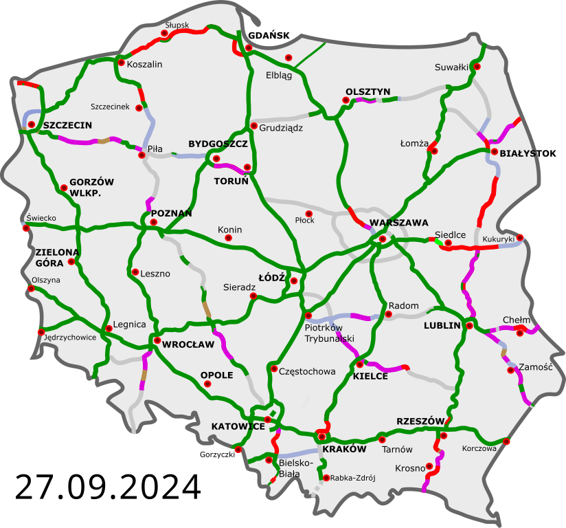
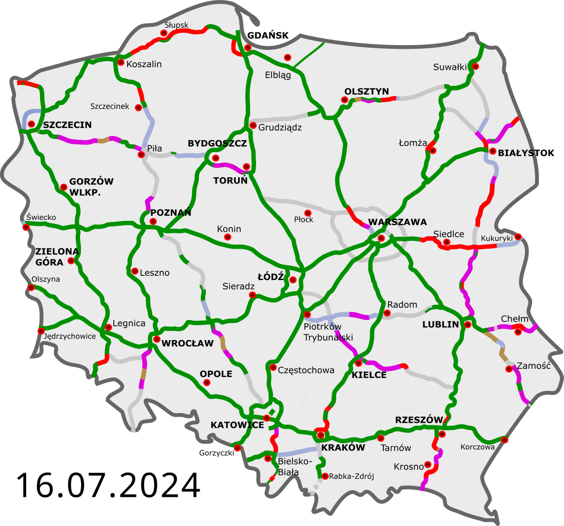
Map of Polish highways with progress of construction
Dettagli[modifica]
| Descrizione |
Polski: Polskie autostrady i drogi ekspresowe:
istniejące przejezdne (na zasadzie tymczasowej organizacji ruchu) w budowie umowa „projektuj i buduj”; etap projektowania w przetargu wydana decyzja środowiskowa planowane English: Polish freeways:
Completed Opened, some works continue Construction Design-build contract (design phase) Tender Environmental permit issued Planned Deutsch: polnische Autobahnen und Schnellstraßen:
fertiggestellt geöffnet, einige Arbeiten gehen weiter im Bau Entwurfs- und Bauvertrag, Entwurfsphase in der Ausschreibung Umweltverträglichkeitsprüfung geplant Čeština: Polské dálnice a rychlostní silnice:
v provozu ve stavbě plánované Esperanto: Polaj aŭtovojoj kaj rapidvojoj:
kompletigitaj malfermitaj, kelkaj laboroj daŭras konstruataj skizo kaj konstrukontrakto, projektfazo ofertataj al konstrufirmaoj planitaj Español: Autopistas y autovias polacas:
abiertas en construcción en proyecto Français : Les autoroutes polonaises:
existantes en construction en projet Magyar: Lengyelország autópályái:
kész szakasz épülő szakasz tervezett szakasz Italiano: Autostrade polacche: aperte al traffico in costruzione progettate |
||
| Data | |||
| Fonte | |||
| Autore |
|
||
| Altre versioni | Opere derivate da questo file: Historia budowy autostrad i dróg ekspresowych.gif | ||
| SVG sviluppo | Il codice sorgente di questo file SVG non è valido a causa di 1 errore. Questa mappa in grafica vettoriale non valida secondo il W3C è stata creata con Inkscape…importante.
|
Licenza[modifica]
Io, detentore del copyright su quest'opera, dichiaro di pubblicarla con le seguenti licenze:
Questo file è disponibile in base alla licenza Creative Commons Attribuzione 3.0 Unported
- Tu sei libero:
- di condividere – di copiare, distribuire e trasmettere quest'opera
- di modificare – di adattare l'opera
- Alle seguenti condizioni:
- attribuzione – Devi fornire i crediti appropriati, un collegamento alla licenza e indicare se sono state apportate modifiche. Puoi farlo in qualsiasi modo ragionevole, ma non in alcun modo che suggerisca che il licenziante approvi te o il tuo uso.
Puoi scegliere la licenza che preferisci.
Registro originale del caricamento[modifica]
This image is a derivative work of the following images:
- DocelowyUkladDrog.svg licensed with Cc-by-3.0, Cc-by-3.0
- 2009-08-30T16:41:32Z Sliwers 784x723 (155471 Bytes) Darker color.
- 2009-08-30T16:40:18Z Sliwers 784x723 (155471 Bytes) Cropped.
- 2009-08-30T16:36:58Z Sliwers 1073x790 (154212 Bytes) {{Information |Description={{en|1=Map of the planned free- and expressway network in Poland.}} {{pl|1=Docelowy układ autostrad i dróg ekspresowych w Polsce.}} {{de|1=Das Autobahn- und Schnellstraßennetz Polens, geplanter E
Uploaded with derivativeFX
Cronologia del file
Fare clic su un gruppo data/ora per vedere il file come si presentava nel momento indicato.
| Data/Ora | Miniatura | Dimensioni | Utente | Commento | |
|---|---|---|---|---|---|
| attuale | 18:08, 26 apr 2024 | | 776 × 723 (360 KB) | Docxent (discussione | contributi) | umowa na projekt i budowę odcinka S11 Gotartów - Olesno. |
| 13:14, 19 apr 2024 |  | 776 × 723 (359 KB) | Docxent (discussione | contributi) | wydanie ZRID dla budowy drugiej jezdni obwodnicy Kocka i Woli Skromowskiej (droga S19) | |
| 18:35, 17 apr 2024 |  | 776 × 723 (359 KB) | Docxent (discussione | contributi) | umowa na proj. i budowę drugiej jezdni obw. Kępna w ciągu drogi S11 | |
| 17:00, 16 apr 2024 |  | 776 × 723 (359 KB) | Docxent (discussione | contributi) | ZRID dla rozbudowy odcinka S19 Sokołów Małopolski Płn. - Jasionka | |
| 13:17, 28 mar 2024 |  | 776 × 723 (359 KB) | Docxent (discussione | contributi) | umowa na proj. i budowę S11 Kępno - Siemianice | |
| 12:43, 28 mar 2024 |  | 776 × 723 (359 KB) | Docxent (discussione | contributi) | Podpisanie umowy na zaprojektowanie i wybudowanie odc. S74 Cedzyna - Łagów | |
| 22:47, 23 mar 2024 |  | 776 × 723 (359 KB) | Docxent (discussione | contributi) | S7 Lesznowola stała org. Ruchu | |
| 22:49, 28 feb 2024 |  | 776 × 723 (360 KB) | Docxent (discussione | contributi) | wydanie ZRID na drogę S19 w rejonie Białegostoku | |
| 22:10, 19 feb 2024 |  | 776 × 723 (360 KB) | Docxent (discussione | contributi) | Umowa na projekt i budowę S19 od Czarnej Białostockiej do węzła Białystok Północ | |
| 20:33, 5 feb 2024 |  | 776 × 723 (360 KB) | Docxent (discussione | contributi) | wydanie DSU na odc. S17 Łopiennik (bez węzła) - Krasnystaw Północ (bez węzła) |
Impossibile sovrascrivere questo file.
Utilizzo del file
Più di 100 pagine usano questo file. Di seguito sono elencate solo le prime 100 pagine che usano questo file. È disponibile un elenco completo.
- User:Chumwa/OgreBot/Potential transport maps/2016 August 21-31
- User:Chumwa/OgreBot/Potential transport maps/2016 December 21-31
- User:Chumwa/OgreBot/Potential transport maps/2016 January 21-31
- User:Chumwa/OgreBot/Potential transport maps/2016 July 1-10
- User:Chumwa/OgreBot/Potential transport maps/2016 July 21-31
- User:Chumwa/OgreBot/Potential transport maps/2018 January 11-20
- User:Chumwa/OgreBot/Potential transport maps/2018 January 21-31
- User:Chumwa/OgreBot/Potential transport maps/2018 November 1-10
- User:Chumwa/OgreBot/Potential transport maps/2018 October 11-20
- User:Chumwa/OgreBot/Potential transport maps/2018 October 21-31
- User:Chumwa/OgreBot/Potential transport maps/2019 April 11-20
- User:Chumwa/OgreBot/Potential transport maps/2019 August 1-10
- User:Chumwa/OgreBot/Potential transport maps/2019 December 11-20
- User:Chumwa/OgreBot/Potential transport maps/2019 December 21-31
- User:Chumwa/OgreBot/Potential transport maps/2019 July 1-10
- User:Chumwa/OgreBot/Potential transport maps/2019 June 1-10
- User:Chumwa/OgreBot/Potential transport maps/2019 June 11-20
- User:Chumwa/OgreBot/Potential transport maps/2019 May 1-10
- User:Chumwa/OgreBot/Potential transport maps/2019 May 21-31
- User:Chumwa/OgreBot/Potential transport maps/2019 November 11-20
- User:Chumwa/OgreBot/Potential transport maps/2019 October 1-10
- User:Chumwa/OgreBot/Potential transport maps/2019 October 11-20
- User:Chumwa/OgreBot/Potential transport maps/2019 September 1-10
- User:Chumwa/OgreBot/Potential transport maps/2019 September 11-20
- User:Chumwa/OgreBot/Potential transport maps/2019 September 21-30
- User:Chumwa/OgreBot/Transport Maps/2015 December 21-31
- User:Chumwa/OgreBot/Transport Maps/2015 July 1-10
- User:Chumwa/OgreBot/Transport Maps/2015 November 1-10
- User:Chumwa/OgreBot/Transport Maps/2015 October 11-20
- User:Chumwa/OgreBot/Transport Maps/2016 August 21-31
- User:Chumwa/OgreBot/Transport Maps/2016 December 21-31
- User:Chumwa/OgreBot/Transport Maps/2016 January 21-31
- User:Chumwa/OgreBot/Transport Maps/2016 July 1-10
- User:Chumwa/OgreBot/Transport Maps/2016 July 21-31
- User:Chumwa/OgreBot/Transport Maps/2018 January 11-20
- User:Chumwa/OgreBot/Transport Maps/2018 January 21-31
- User:Chumwa/OgreBot/Transport Maps/2018 November 1-10
- User:Chumwa/OgreBot/Transport Maps/2018 October 11-20
- User:Chumwa/OgreBot/Transport Maps/2018 October 21-31
- User:Chumwa/OgreBot/Transport Maps/2019 April 11-20
- User:Chumwa/OgreBot/Transport Maps/2019 August 1-10
- User:Chumwa/OgreBot/Transport Maps/2019 December 11-20
- User:Chumwa/OgreBot/Transport Maps/2019 December 21-31
- User:Chumwa/OgreBot/Transport Maps/2019 July 1-10
- User:Chumwa/OgreBot/Transport Maps/2019 June 1-10
- User:Chumwa/OgreBot/Transport Maps/2019 June 11-20
- User:Chumwa/OgreBot/Transport Maps/2019 May 1-10
- User:Chumwa/OgreBot/Transport Maps/2019 May 21-31
- User:Chumwa/OgreBot/Transport Maps/2019 November 11-20
- User:Chumwa/OgreBot/Transport Maps/2019 October 1-10
- User:Chumwa/OgreBot/Transport Maps/2019 October 11-20
- User:Chumwa/OgreBot/Transport Maps/2019 September 1-10
- User:Chumwa/OgreBot/Transport Maps/2019 September 11-20
- User:Chumwa/OgreBot/Transport Maps/2019 September 21-30
- User:Chumwa/OgreBot/Transport Maps/2020 April 21-30
- User:Chumwa/OgreBot/Transport Maps/2020 December 1-10
- User:Chumwa/OgreBot/Transport Maps/2020 December 11-20
- User:Chumwa/OgreBot/Transport Maps/2020 December 21-31
- User:Chumwa/OgreBot/Transport Maps/2020 March 11-20
- User:Chumwa/OgreBot/Transport Maps/2020 May 11-20
- User:Chumwa/OgreBot/Transport Maps/2020 November 1-10
- User:Chumwa/OgreBot/Transport Maps/2020 November 11-20
- User:Chumwa/OgreBot/Transport Maps/2020 November 21-30
- User:Chumwa/OgreBot/Transport Maps/2020 October 11-20
- User:Chumwa/OgreBot/Transport Maps/2020 October 21-31
- User:Chumwa/OgreBot/Travel and communication maps/2016 August 21-31
- User:Chumwa/OgreBot/Travel and communication maps/2016 December 21-31
- User:Chumwa/OgreBot/Travel and communication maps/2016 January 21-31
- User:Chumwa/OgreBot/Travel and communication maps/2016 July 1-10
- User:Chumwa/OgreBot/Travel and communication maps/2016 July 21-31
- User:Chumwa/OgreBot/Travel and communication maps/2018 January 11-20
- User:Chumwa/OgreBot/Travel and communication maps/2018 January 21-31
- User:Chumwa/OgreBot/Travel and communication maps/2018 November 1-10
- User:Chumwa/OgreBot/Travel and communication maps/2018 October 11-20
- User:Chumwa/OgreBot/Travel and communication maps/2018 October 21-31
- User:Chumwa/OgreBot/Travel and communication maps/2019 April 11-20
- User:Chumwa/OgreBot/Travel and communication maps/2019 August 1-10
- User:Chumwa/OgreBot/Travel and communication maps/2019 December 11-20
- User:Chumwa/OgreBot/Travel and communication maps/2019 December 21-31
- User:Chumwa/OgreBot/Travel and communication maps/2019 July 1-10
- User:Chumwa/OgreBot/Travel and communication maps/2019 June 1-10
- User:Chumwa/OgreBot/Travel and communication maps/2019 June 11-20
- User:Chumwa/OgreBot/Travel and communication maps/2019 May 1-10
- User:Chumwa/OgreBot/Travel and communication maps/2019 May 21-31
- User:Chumwa/OgreBot/Travel and communication maps/2019 November 11-20
- User:Chumwa/OgreBot/Travel and communication maps/2019 October 1-10
- User:Chumwa/OgreBot/Travel and communication maps/2019 October 11-20
- User:Chumwa/OgreBot/Travel and communication maps/2019 September 1-10
- User:Chumwa/OgreBot/Travel and communication maps/2019 September 11-20
- User:Chumwa/OgreBot/Travel and communication maps/2019 September 21-30
- User:Chumwa/OgreBot/Travel and communication maps/2020 April 21-30
- User:Chumwa/OgreBot/Travel and communication maps/2020 December 1-10
- User:Chumwa/OgreBot/Travel and communication maps/2020 December 11-20
- User:Chumwa/OgreBot/Travel and communication maps/2020 December 21-31
- User:Chumwa/OgreBot/Travel and communication maps/2020 March 11-20
- User:Chumwa/OgreBot/Travel and communication maps/2020 May 11-20
- User:Chumwa/OgreBot/Travel and communication maps/2020 November 1-10
- User:Chumwa/OgreBot/Travel and communication maps/2020 November 11-20
- User:Chumwa/OgreBot/Travel and communication maps/2020 November 21-30
- User:Chumwa/OgreBot/Travel and communication maps/2020 October 11-20
Visualizza altri collegamenti a questo file.
Utilizzo globale del file
Anche i seguenti wiki usano questo file:
- Usato nelle seguenti pagine di bg.wikipedia.org:
- Usato nelle seguenti pagine di cs.wikipedia.org:
- Usato nelle seguenti pagine di de.wikipedia.org:
- Usato nelle seguenti pagine di de.wikivoyage.org:
- Usato nelle seguenti pagine di en.wikipedia.org:
- Usato nelle seguenti pagine di en.wikivoyage.org:
- Usato nelle seguenti pagine di eo.wikipedia.org:
- Usato nelle seguenti pagine di eo.wikivoyage.org:
- Usato nelle seguenti pagine di es.wikivoyage.org:
- Usato nelle seguenti pagine di fi.wikipedia.org:
- Usato nelle seguenti pagine di fr.wikipedia.org:
- Usato nelle seguenti pagine di fr.wikivoyage.org:
- Usato nelle seguenti pagine di he.wikivoyage.org:
- Usato nelle seguenti pagine di hu.wikipedia.org:
- Usato nelle seguenti pagine di it.wikipedia.org:
- Usato nelle seguenti pagine di it.wikivoyage.org:
- Usato nelle seguenti pagine di ja.wikipedia.org:
- Usato nelle seguenti pagine di nl.wikipedia.org:
- Usato nelle seguenti pagine di nl.wikivoyage.org:
- Usato nelle seguenti pagine di pl.wikipedia.org:
- Usato nelle seguenti pagine di pl.wikivoyage.org:
- Usato nelle seguenti pagine di pt.wikivoyage.org:
- Usato nelle seguenti pagine di ro.wikipedia.org:
- Usato nelle seguenti pagine di ro.wikivoyage.org:
- Usato nelle seguenti pagine di ru.wikipedia.org:
- Usato nelle seguenti pagine di ru.wikivoyage.org:
- Usato nelle seguenti pagine di sh.wikipedia.org:
- Usato nelle seguenti pagine di sr.wikipedia.org:
- Usato nelle seguenti pagine di sv.wikipedia.org:
- Usato nelle seguenti pagine di sv.wikivoyage.org:
- Usato nelle seguenti pagine di tr.wikipedia.org:
- Usato nelle seguenti pagine di uk.wikipedia.org:
- Usato nelle seguenti pagine di vi.wikipedia.org: