File:Highways SK map v3.svg
Jump to navigation
Jump to search

Size of this PNG preview of this SVG file: 800 × 405 pixels. Other resolutions: 320 × 162 pixels | 640 × 324 pixels | 1,024 × 519 pixels | 1,280 × 649 pixels | 2,560 × 1,297 pixels | 1,500 × 760 pixels.
Original file (SVG file, nominally 1,500 × 760 pixels, file size: 220 KB)
Captions
Captions
Add a one-line explanation of what this file represents
Summary[edit]
| Description |
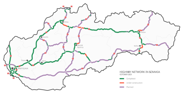
Slovenčina: Diaľnice a rýchlostné cesty na Slovensku:
v prevádzke
vo výstavbe
plánované English: Motorways and expressways in Slovakia:
Completed
Under construction
Planned Deutsch: Autobahnen und Schnellstraßen in der Slowakei:
in Betrieb
in Bau
in Planung Čeština: Dálnice a rychlostní silnice na Slovensku:
v provozu
ve výstavbě
plánované Polski: Autostrady i drogi ekspresowe na Słowacji:
istniejące
w budowie
planowane Magyar: Autópályák és autóutak Szlovákiában:
kész szakasz
épülő szakasz
tervezett szakasz Español: Autopistas y autovias en Eslovaquia:
abiertas
en construcción
en proyecto Français : Autoroutes en Slovaquie:
existantes
en construction
en projet Italiano: Autostrade e superstrade in Slovacchia:
aperte al traffico
in costruzione
progettate Română: Autostrăzi în Slovacia:
autostrăzile existente
autostrăzile în curs de construcție
autostrăzile planuite |
||||
| Date | |||||
| Source | Own work | ||||
| Author | Krumpi | ||||
| Other versions |
|


Licensing[edit]
I, the copyright holder of this work, hereby publish it under the following license:
This file is licensed under the Creative Commons Attribution-Share Alike 4.0 International license.
- You are free:
- to share – to copy, distribute and transmit the work
- to remix – to adapt the work
- Under the following conditions:
- attribution – You must give appropriate credit, provide a link to the license, and indicate if changes were made. You may do so in any reasonable manner, but not in any way that suggests the licensor endorses you or your use.
- share alike – If you remix, transform, or build upon the material, you must distribute your contributions under the same or compatible license as the original.
File history
Click on a date/time to view the file as it appeared at that time.
| Date/Time | Thumbnail | Dimensions | User | Comment | |
|---|---|---|---|---|---|
| current | 16:25, 13 October 2023 | | 1,500 × 760 (220 KB) | Krumpi (talk | contribs) | update |
| 19:27, 4 October 2021 |  | 1,500 × 760 (297 KB) | Hornokysučan (talk | contribs) | new completed sections | |
| 22:53, 16 December 2019 |  | 1,500 × 760 (314 KB) | Krumpi (talk | contribs) | Completed section D1 Budimír - Bidovce | |
| 19:19, 15 September 2019 |  | 1,500 × 760 (314 KB) | Krumpi (talk | contribs) | new color scheme | |
| 19:25, 7 September 2019 |  | 1,500 × 760 (267 KB) | Krumpi (talk | contribs) | New sections under construction: • R2 Mýtna - Lovinobaňa • Prešov - northern bypass | |
| 22:01, 11 December 2018 |  | 1,500 × 760 (273 KB) | Krumpi (talk | contribs) | User created page with UploadWizard |
You cannot overwrite this file.
File usage on Commons
The following 21 pages use this file:
- User:Chumwa/OgreBot/Potential transport maps/2018 December 11-20
- User:Chumwa/OgreBot/Potential transport maps/2019 December 11-20
- User:Chumwa/OgreBot/Potential transport maps/2019 September 1-10
- User:Chumwa/OgreBot/Potential transport maps/2019 September 11-20
- User:Chumwa/OgreBot/Transport Maps/2018 December 11-20
- User:Chumwa/OgreBot/Transport Maps/2019 December 11-20
- User:Chumwa/OgreBot/Transport Maps/2019 September 1-10
- User:Chumwa/OgreBot/Transport Maps/2019 September 11-20
- User:Chumwa/OgreBot/Transport Maps/2021 October 1-10
- User:Chumwa/OgreBot/Transport Maps/2023 October 11-20
- User:Chumwa/OgreBot/Travel and communication maps/2018 December 11-20
- User:Chumwa/OgreBot/Travel and communication maps/2019 December 11-20
- User:Chumwa/OgreBot/Travel and communication maps/2019 September 1-10
- User:Chumwa/OgreBot/Travel and communication maps/2019 September 11-20
- User:Chumwa/OgreBot/Travel and communication maps/2021 October 1-10
- User:Chumwa/OgreBot/Travel and communication maps/2023 October 11-20
- User:Krumpi/gallery
- File:Diaľnice a rýchlostné cesty na Slovensku.png
- File:Highway network in slovakia.pdf
- File:Highways SK map.svg
- File:Highways SK map v2.svg
File usage on other wikis
The following other wikis use this file:
- Usage on az.wikipedia.org
- Usage on be.wikipedia.org
- Usage on ca.wikipedia.org
- Usage on de.wikipedia.org
- Usage on el.wikipedia.org
- Usage on fi.wikipedia.org
- Usage on fr.wikipedia.org
- Usage on fr.wikivoyage.org
- Usage on hu.wikipedia.org
- Usage on it.wikipedia.org
- Usage on nl.wikipedia.org
- Usage on pl.wikipedia.org
- Usage on ro.wikipedia.org
- Usage on ru.wikipedia.org
- Usage on sk.wikipedia.org
- Usage on sl.wikipedia.org
- Usage on sv.wikipedia.org
- Usage on te.wikipedia.org
- Usage on uk.wikipedia.org
- Usage on zh.wikipedia.org