File:Himalaya annotated.jpg
跳至導覽
跳至搜尋

預覽大小:800 × 530 像素。 其他解析度:320 × 212 像素 | 640 × 424 像素 | 1,000 × 662 像素。
原始檔案 (1,000 × 662 像素,檔案大小:413 KB,MIME 類型:image/jpeg)
說明
說明
添加單行說明來描述出檔案所代表的內容
| 描述 |
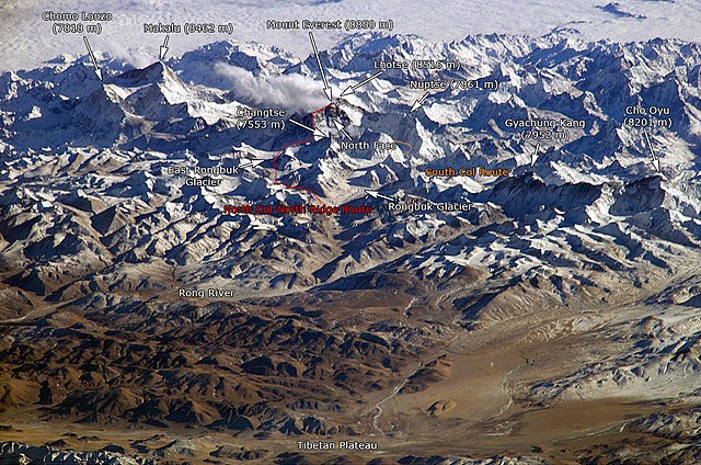
English: The Himalayan mountain range with Mount Everest as seen from the International Space Station looking south-south-east over the Tibetan Plateau. Four of the world's fourteen eight-thousanders, mountains higher than 8000 metres, can be seen, Makalu (8462 m), Everest (8850 m), Lhotse (8516 m) and Cho Oyu (8201 m). The South Col Route is Mount Everest's most often used climbing route. |
|||||
| 來源 |
This image is a modified version of this NASA Image. Annotations have been added by Janderk Jan Derk. If anyone finds errors please leave a note in the discussions area of this page. Original image: NASA |
|||||
| 作者 | NASA, Janderk Jan Derk | |||||
| 授權許可 (重用此檔案) |
|
|||||
| 其他版本 |
本檔案衍生自: Himalayas.jpg |

檔案歷史
點選日期/時間以檢視該時間的檔案版本。
| 日期/時間 | 縮圖 | 尺寸 | 使用者 | 備註 | |
|---|---|---|---|---|---|
| 目前 | 2006年12月6日 (三) 22:39 | | 1,000 × 662(413 KB) | Janderk~commonswiki(留言 | 貢獻) | Slight change in Nuptse location to try to make it point more to Nuptse I. |
| 2006年12月5日 (二) 12:08 |  | 1,000 × 662(414 KB) | Janderk~commonswiki(留言 | 貢獻) | Fixed errors. See talk page. | |
| 2005年2月19日 (六) 18:23 |  | 1,000 × 662(416 KB) | RedWolf(留言 | 貢獻) | Himalaya - annotated |
無法覆蓋此檔案。
檔案用途
下列4個頁面有用到此檔案:
全域檔案使用狀況
以下其他 wiki 使用了這個檔案:
- af.wikipedia.org 的使用狀況
- anp.wikipedia.org 的使用狀況
- ast.wikipedia.org 的使用狀況
- awa.wikipedia.org 的使用狀況
- azb.wikipedia.org 的使用狀況
- az.wikipedia.org 的使用狀況
- ba.wikipedia.org 的使用狀況
- bcl.wikipedia.org 的使用狀況
- beta.wikiversity.org 的使用狀況
- be.wikipedia.org 的使用狀況
- bg.wikipedia.org 的使用狀況
- blk.wikipedia.org 的使用狀況
- bn.wikipedia.org 的使用狀況
- bs.wikipedia.org 的使用狀況
- ca.wikipedia.org 的使用狀況
- ckb.wikipedia.org 的使用狀況
- csb.wikipedia.org 的使用狀況
- cs.wikipedia.org 的使用狀況
- da.wikipedia.org 的使用狀況
- de.wikipedia.org 的使用狀況
- el.wikipedia.org 的使用狀況
- en.wikipedia.org 的使用狀況
- eo.wikipedia.org 的使用狀況
檢視此檔案的更多全域使用狀況。