File:Historic heritage sites of Chhattisgarh with GPS coordinates.jpg

Original file (2,270 × 2,590 pixels, file size: 1.26 MB, MIME type: image/jpeg)
Captions
Captions
Summary[edit]
| Description |
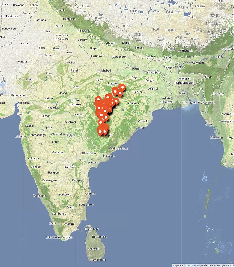
English: Chhattisgarh is a state in central India with a rich cultural history of architecture and arts. This map shows about hundred major historic sites in Chattisgarh from about 400 BCE to 1800 CE.
These are predominantly Hindu monuments, as well as monuments belonging to the Jain, Buddhist and other religious groups found in India. Many of these sites have been restored in the modern era wherein historic ruins and artwork has been retained or reused. They thus hold pre-14th century ruins left over after a period of vandalism and destruction. Some sites pinned above have been partially or fully excavated between 1850 and 2015 CE. Over fifty of these are well preserved and show remarkable artistic achievements by artisans (shilpins) of the Maghadas, Mauryas, Ikshvakus, Guptas, Vakatakas, Parivrajakas, Kalachuris, Dakshina Koshalas, Seuna-Yadavas, Kakatiyas, and other periods. A list of major sites pinned in this map are listed below. The GPS coordinates are based on actual field surveys and visits since 2016. Shiva temple and museum, Dipadih 23°18′07″N 83°43′30″E / 23.30201°N 83.725009°E Shiv Mandir, Harratoli 23°19′24″N 83°36′35″E / 23.32330°N 83.609612°E Deur Temple, Maharanipur 22°44′00″N 83°27′15″E / 22.73340°N 83.454173°E Pujaripali temple, Maharajpur 21°38′42″N 83°21′00″E / 21.644920°N 83.350085°E Ashtabhuji Temple, Adbhar 21°57′11″N 83°01′29″E / 21.95298°N 83.024856°E Shiva temple, Maheshpur 22°54′06″N 82°59′55″E / 22.901637°N 82.998734°E Shiv Mandir, Devgarh 23°01′05″N 82°56′57″E / 23.01818°N 82.949293°E Chherika Deur, Devtikara-Udaypur 23°01′09″N 82°56′39″E / 23.01903°N 82.944190°E Sitabengra & Jogimara Caves 22°53′55″N 82°55′50″E / 22.898735°N 82.930559°E Satmahala¬†temples, Kalcha-Bhadwahi 23°01′09″N 82°55′27″E / 23.01904°N 82.924115°E Sheorinarayan Temple, Shivrinarayan 21°43′10″N 82°35′23″E / 21.71933°N 82.589788°E Indal Dev Mandir, Kharod 21°44′48″N 82°34′47″E / 21.74680°N 82.579606°E Maa Shabri Temple, Kharod 21°44′26″N 82°34′41″E / 21.74060°N 82.577954°E Laxmaneshwar Temple, Kharod 21°44′46″N 82°34′32″E / 21.74614°N 82.575468°E Vishnu Bhagwan Temple, Janjgir 22°00′21″N 82°34′20″E / 22.00596°N 82.572186°E Small Vishnu Mandir, Janjgir 22°00′22″N 82°34′20″E / 22.006208°N 82.572179°E Shiva temple ruins, Tuman 22°34′30″N 82°25′20″E / 22.57492°N 82.422313°E Shiva temple, Narayanpur Balodabazar 21°34′34″N 82°22′13″E / 21.57617°N 82.370366°E Turturiya Dham 21°29′33″N 82°21′46″E / 21.49239°N 82.362832°E Shiv Mandir, Pali 22°22′23″N 82°19′24″E / 22.37313°N 82.323453°E Jagannath mandir, Khallari 21°05′41″N 82°17′08″E / 21.09460°N 82.285653°E Khallari Mata Mandir, Khallari 21°05′33″N 82°16′53″E / 21.09242°N 82.281301°E Pataleshwar Temple and Museum, Malhar 21°53′44″N 82°16′48″E / 21.89568°N 82.280043°E Bhim Kichak Temple, Malhar 21°53′34″N 82°16′40″E / 21.89288°N 82.277665°E Shiva temple ruins and Mahamaya Mandir, Damru 21°43′22″N 82°15′22″E / 21.722682°N 82.256056°E Rama Temple Complex, Sirpur 21°21′07″N 82°11′17″E / 21.35181°N 82.187927°E Laxman Temple and Museum, Sirpur 21°21′11″N 82°11′12″E / 21.35311°N 82.186712°E Buddhist and Shiva Temple ruins, Sirpur 21°20′59″N 82°11′06″E / 21.349627°N 82.184993°E Teevardev temple and Buddhist monastery, Sirpur 21°20′43″N 82°11′06″E / 21.34524°N 82.184871°E Anandprabhu Vihara, Baleshwar Shiv temple, Sirpur 21°20′26″N 82°11′00″E / 21.34057°N 82.183226°E Dhatu Murti temple, Sirpur 21°21′03″N 82°11′00″E / 21.350843°N 82.183199°E Surang Temple, Sirpur 21°20′48″N 82°10′56″E / 21.34655°N 82.182212°E Swastik Vihara, Sirpur 21°20′30″N 82°10′53″E / 21.34165°N 82.181494°E Shiva and Parvati temple, Sirpur 21°20′23″N 82°10′48″E / 21.339788°N 82.180042°E Gandheswar Shiv Temple, Sirpur 21°20′57″N 82°10′47″E / 21.34918°N 82.179774°E Siddheshwar mandir, Palari 21°32′05″N 82°10′39″E / 21.53467°N 82.177549°E Ancient Fort and Temple ruins, Ratanpur 22°17′02″N 82°10′00″E / 22.28390°N 82.166531°E Kanthi Deul, Ratanpur 22°17′20″N 82°09′36″E / 22.28902°N 82.160019°E Mahamaya Temple, Ratanpur 22°17′18″N 82°09′36″E / 22.28842°N 82.159974°E Mahamaya Devi Temple , Ratanpur 22°17′18″N 82°09′36″E / 22.288426°N 82.159974°E Panchamukhi Shiva Temple, Ratanpur 22°17′18″N 82°09′33″E / 22.28829°N 82.159106°E Dhumnath tempale, Deo kirarigodhi 21°55′43″N 82°05′19″E / 21.92849°N 82.088653°E Shiv Mandir, Kirarigodhi 21°55′33″N 82°05′08″E / 21.92595°N 82.085528°E Shri Jatmai Mata Temple, Gariyaband 20°47′26″N 82°03′52″E / 20.79059°N 82.064545°E Ghatarani Waterfall, Ghatarani 20°49′41″N 82°03′35″E / 20.82805°N 82.059794°E Shiv mandir, Ganiyari 22°11′31″N 82°02′37″E / 22.19194°N 82.043664°E Fanikeshwar Mahadev, Fingeshwar 20°58′16″N 82°02′31″E / 20.97121°N 82.041943°E Shri Panchmadir Temple, Fingeshwar 20°58′15″N 82°02′30″E / 20.97086°N 82.041747°E Devrani Jethani Mandir, Tala Amerikanpa 21°54′26″N 82°01′34″E / 21.907156°N 82.026019°E Dhumnath mandir, Sargaon 21°54′05″N 81°58′30″E / 21.901428°N 81.974993°E Bhand Deul Temple, Arang 21°11′42″N 81°58′10″E / 21.19509°N 81.969573°E Shree Harihar Kshetra, Madku dweep 21°50′21″N 81°56′59″E / 21.83905°N 81.949846°E Shiv Temple, Bastar 19°12′44″N 81°55′58″E / 19.212251°N 81.932729°E Karneswar Mandir, Sihawa 20°18′56″N 81°55′39″E / 20.31542°N 81.927623°E Godiyari Mandir, Kesharpal 19°23′15″N 81°54′06″E / 19.38742°N 81.901730°E Shri Ram Janki Mandir Rajim 20°57′47″N 81°52′44″E / 20.96317°N 81.878884°E Rajiv Lochan Temples, Rajim 20°57′50″N 81°52′39″E / 20.96396°N 81.877581°E Sita Bari, Rajim 20°57′48″N 81°52′35″E / 20.96340°N 81.876471°E Kuleshwar Mahadev temple, Nawagaon 20°57′44″N 81°52′18″E / 20.96218°N 81.871567°E Shiv Temple, Chandkhuri 21°19′11″N 81°49′05″E / 21.31984°N 81.818180°E Rajarajeshwari Mahadev Mandir, Nawagaon 21°13′17″N 81°48′44″E / 21.22143°N 81.812127°E Mavli Mata Mandir, Tarponga 21°45′44″N 81°47′18″E / 21.76210°N 81.788361°E Dodrepal Temple, Dodrepal 18°59′26″N 81°47′02″E / 18.99049°N 81.784011°E Shiv Shakti Dham temple, Ghumadpal 18°53′45″N 81°46′17″E / 18.89589°N 81.771256°E Chitavari Devi Temple, Dhobani 21°41′49″N 81°45′07″E / 21.69691°N 81.751958°E Shiv Mandir Singhaigudi, Ghumarmund Para 19°08′07″N 81°44′35″E / 19.13532°N 81.742920°E Narayan temple, Narayanpal 19°12′00″N 81°44′25″E / 19.19997°N 81.740228°E Somnath Mandir, Shivanath-Kharun sangam 21°34′00″N 81°40′07″E / 21.56666°N 81.668489°E Shiv Temple, Girod 21°20′50″N 81°39′16″E / 21.34713°N 81.654445°E Mahant Ghasidas Memorial Museum, Raipur 21°14′38″N 81°38′42″E / 21.24388°N 81.644917°E Gobrahin Shiv Temple, Keshkal Dhanora 20°04′20″N 81°33′18″E / 20.07211°N 81.554905°E Temple ruins?, Garh Dhanora 20°04′25″N 81°33′12″E / 20.07356°N 81.553269°E Shiva Mandir, Deobaloda 21°13′08″N 81°28′25″E / 21.21878°N 81.473480°E Rudra temple, Onakona 20°34′28″N 81°26′41″E / 20.57458°N 81.444609°E Sita Devi Temple, Deorbija 21°40′11″N 81°24′30″E / 21.66965°N 81.408326°E Bauddh Chaitya Griha, Bhongapal 19°49′49″N 81°23′47″E / 19.83026°N 81.396296°E Vishnu Mandir, Banbarad 21°20′15″N 81°23′18″E / 21.337501°N 81.388333°E Chandraditya Temple, Barsoor 19°08′14″N 81°22′57″E / 19.13712°N 81.382540°E Battisa Temple, Barsoor 19°08′06″N 81°22′56″E / 19.13492°N 81.382185°E Pedamma Mandir, Barsoor 19°07′52″N 81°22′31″E / 19.13114°N 81.375298°E Mama Bhanja Temple, Basroor 19°08′16″N 81°22′25″E / 19.13764°N 81.373636°E Ganesh Temple, Barsoor 19°08′03″N 81°22′25″E / 19.13414°N 81.373606°E Danteshwari Mandir, Dantewada 18°53′48″N 81°20′42″E / 18.89656°N 81.345044°E Manchi Of Mata Bahadur Kalarin 20°42′30″N 81°20′12″E / 20.70825°N 81.336748°E Shiv-Vishnu Mandir, Dhamdha 21°27′26″N 81°19′48″E / 21.45733°N 81.330015°E Bajrang Bali Mandir, Sahaspur 21°32′07″N 81°17′36″E / 21.535332°N 81.293340°E Shiv Mandir, Sahaspur 21°32′08″N 81°17′35″E / 21.53560°N 81.293118°E Nagdev Jain Mandir, Nagpura 21°14′41″N 81°14′07″E / 21.24464°N 81.235256°E Shiv Temple, Nagpura 21°14′48″N 81°13′58″E / 21.24660°N 81.232916°E Uwassaggaharam Parshwa Tirth, Nagpura 21°13′52″N 81°12′53″E / 21.23119°N 81.214596°E Kapileshwar temples, Balod 20°44′15″N 81°12′39″E / 20.73762°N 81.210871°E Shiv Temple, Jagannathpur village 20°47′28″N 81°11′59″E / 20.79121°N 81.199846°E Mandawa Mahal, Chhapari 22°06′33″N 81°09′15″E / 22.10915°N 81.154075°E Chherki Mahal, Chaura‚ÄìChhapari 22°06′33″N 81°08′55″E / 22.10910°N 81.148726°E Kukurdev Mandir, Malighori-Khapri 20°45′56″N 81°08′55″E / 20.76543°N 81.148628°E Bhoramdev Temple, Chhapari 22°06′55″N 81°08′54″E / 22.11514°N 81.148235°E Shiv Mandir, Gandai 21°39′54″N 81°06′24″E / 21.66503°N 81.106654°E Shiv Mandir, Ghatiyari 21°40′40″N 81°03′33″E / 21.67766°N 81.059292°E Maa Bamleshwari Temple, Dongargarh 21°10′43″N 80°45′02″E / 21.17858°N 80.750611°E This map is a derivative work on the open source, creative commons Open Street Map base map, and therefore OSM CC-licensing terms co-apply.
|
|||||||||||||||
| Date | ||||||||||||||||
| Source | Own work | |||||||||||||||
| Author | Ms Sarah Welch |
Licensing[edit]
- You are free:
- to share – to copy, distribute and transmit the work
- to remix – to adapt the work
- Under the following conditions:
- attribution – You must give appropriate credit, provide a link to the license, and indicate if changes were made. You may do so in any reasonable manner, but not in any way that suggests the licensor endorses you or your use.
- share alike – If you remix, transform, or build upon the material, you must distribute your contributions under the same or compatible license as the original.
File history
Click on a date/time to view the file as it appeared at that time.
| Date/Time | Thumbnail | Dimensions | User | Comment | |
|---|---|---|---|---|---|
| current | 16:06, 14 November 2022 | | 2,270 × 2,590 (1.26 MB) | Ms Sarah Welch (talk | contribs) | Uploaded own work with UploadWizard |
You cannot overwrite this file.
File usage on Commons
There are no pages that use this file.