File:Historical expanse of Ainu.png
跳去導覽
跳去搵嘢
冇更高解像度嘅圖像。
Historical_expanse_of_Ainu.png (632 × 505 像素,檔案大細:110 KB ,MIME類型:image/png)
Captions
Captions
Add a one-line explanation of what this file represents
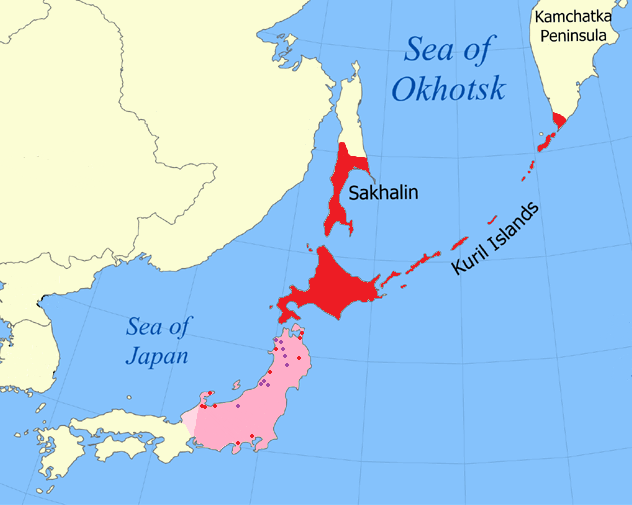
Attested and suspected historical range of the Ainu languages
摘要[編輯]
| 描述 |
English: Historically attested range of Ainu (red) and suspected former range (pink) based on toponymic evidence (red dots), Matagi villages (purple), and Japanese isoglosses (western limit) with modern-day borders shown |
| 日期 | |
| 來源 |
Various, including Vovin, Alexander (2008年) Man'yōshū to Fudoki ni Mirareru Fushigina Kotoba to Jōdai Nihon Retto ni Okeru Ainugo no Bunpu、Kokusai Nihon Bunka Kenkyū Sentā. Archived from the original on 2014年2月11號. Retrieved on 2011年3月27號. |
| 作者 | Kwamikagami |
| Other versions |
 |

協議[編輯]
I, the copyright holder of this work, hereby publish it under the following licenses:
呢個檔案用共享創意 姓名標示-非商業性-相同方式分享3.0 未本地化版本條款授權。
- 你可以:
- 去分享 – 複製、發佈同傳播呢個作品
- 再改 – 創作演繹作品
- 要遵照下面嘅條件:
- 署名 – 你一定要畀合適嘅表彰、畀返指向呢個授權條款嘅連結,同埋寫明有無改過嚟。你可以用任何合理方式去做,但唔可以用任何方式暗示授權人認可咗你或者你嘅使用方式。
- 相同方式分享 – 如果你用任何方式改過呢個作品,你必須要用返原本或者相似嘅條款發佈。

|
根據自由軟體基金會發佈嘅無固定段落、封面文字同封底文字GNU自由文件授權條款第1.2或打後嘅版本,你獲授權可以重製、散佈同埋修改爾份文件。授權條款嘅副本喺章節GNU自由文件授權條款。 |
你可以揀你想用嘅牌照。
檔案歷史
撳個日期/時間去睇響嗰個時間出現過嘅檔案。
| 日期/時間 | 縮圖 | 尺寸 | 用戶 | 註解 | |
|---|---|---|---|---|---|
| 現時 | 2018年1月29號 (一) 00:11 | | 632 × 505(110 KB) | FogueraC(傾偈 | 貢獻) | Reverted to version as of 00:34, 4 April 2013 (UTC) |
| 2017年4月18號 (二) 15:55 |  | 632 × 505(100 KB) | 일성강(傾偈 | 貢獻) | fixed | |
| 2013年4月4號 (四) 00:34 |  | 632 × 505(110 KB) | Kwamikagami(傾偈 | 貢獻) | (didn't take) | |
| 2013年4月4號 (四) 00:29 |  | 632 × 505(110 KB) | Kwamikagami(傾偈 | 貢獻) | nonparallel isoglosses | |
| 2011年12月18號 (日) 05:24 |  | 632 × 505(110 KB) | Kwamikagami(傾偈 | 貢獻) | per Japanese isoglosses | |
| 2011年5月7號 (六) 14:14 |  | 632 × 505(110 KB) | Kwamikagami(傾偈 | 貢獻) | add matagi villages | |
| 2011年4月8號 (五) 05:33 |  | 632 × 505(110 KB) | Kwamikagami(傾偈 | 貢獻) | Shōnai | |
| 2011年2月22號 (二) 08:03 |  | 632 × 505(110 KB) | Kwamikagami(傾偈 | 貢獻) | oops--kamchatka historically attested | |
| 2011年2月22號 (二) 07:57 |  | 632 × 505(110 KB) | Kwamikagami(傾偈 | 貢獻) | reduced area in Kamchatka, per ''Atlas of languages of intercultural communication in the Pacific, Asia and the Americas'', Map 112 | |
| 2011年2月22號 (二) 02:26 |  | 632 × 505(110 KB) | Kwamikagami(傾偈 | 貢獻) | add river in Iwate |
你無得衾咗個檔案。
檔案用途
以下嘅1版用到呢個檔:
全域檔案使用情況
下面嘅維基都用緊呢個檔案:
- af.wikipedia.org嘅使用情況
- als.wikipedia.org嘅使用情況
- bcl.wikipedia.org嘅使用情況
- be.wikipedia.org嘅使用情況
- bn.wikipedia.org嘅使用情況
- cs.wikipedia.org嘅使用情況
- da.wikipedia.org嘅使用情況
- de.wikipedia.org嘅使用情況
- en.wikipedia.org嘅使用情況
- en.wikiversity.org嘅使用情況
- es.wikipedia.org嘅使用情況
- et.wikipedia.org嘅使用情況
- fa.wikipedia.org嘅使用情況
- fi.wikipedia.org嘅使用情況
- fo.wikipedia.org嘅使用情況
- frr.wikipedia.org嘅使用情況
- fr.wikipedia.org嘅使用情況
- fy.wikipedia.org嘅使用情況
- gl.wikipedia.org嘅使用情況
- hsb.wikipedia.org嘅使用情況
- hu.wikipedia.org嘅使用情況
- hy.wikipedia.org嘅使用情況
- id.wikipedia.org嘅使用情況
- it.wikipedia.org嘅使用情況
- kk.wikipedia.org嘅使用情況
睇呢個檔案嘅更多全域使用情況。