File:Hoher-Giessel-Wasserfall Grosse-Lauter Schwaebische-Alb.jpg
Jump to navigation
Jump to search
Size of this preview: 800 × 533 pixels. Other resolutions: 320 × 213 pixels | 640 × 427 pixels | 1,024 × 683 pixels | 1,280 × 853 pixels | 1,800 × 1,200 pixels.
Original file (1,800 × 1,200 pixels, file size: 2.15 MB, MIME type: image/jpeg)
Captions
Captions
Add a one-line explanation of what this file represents
Summary
[edit]| Description |
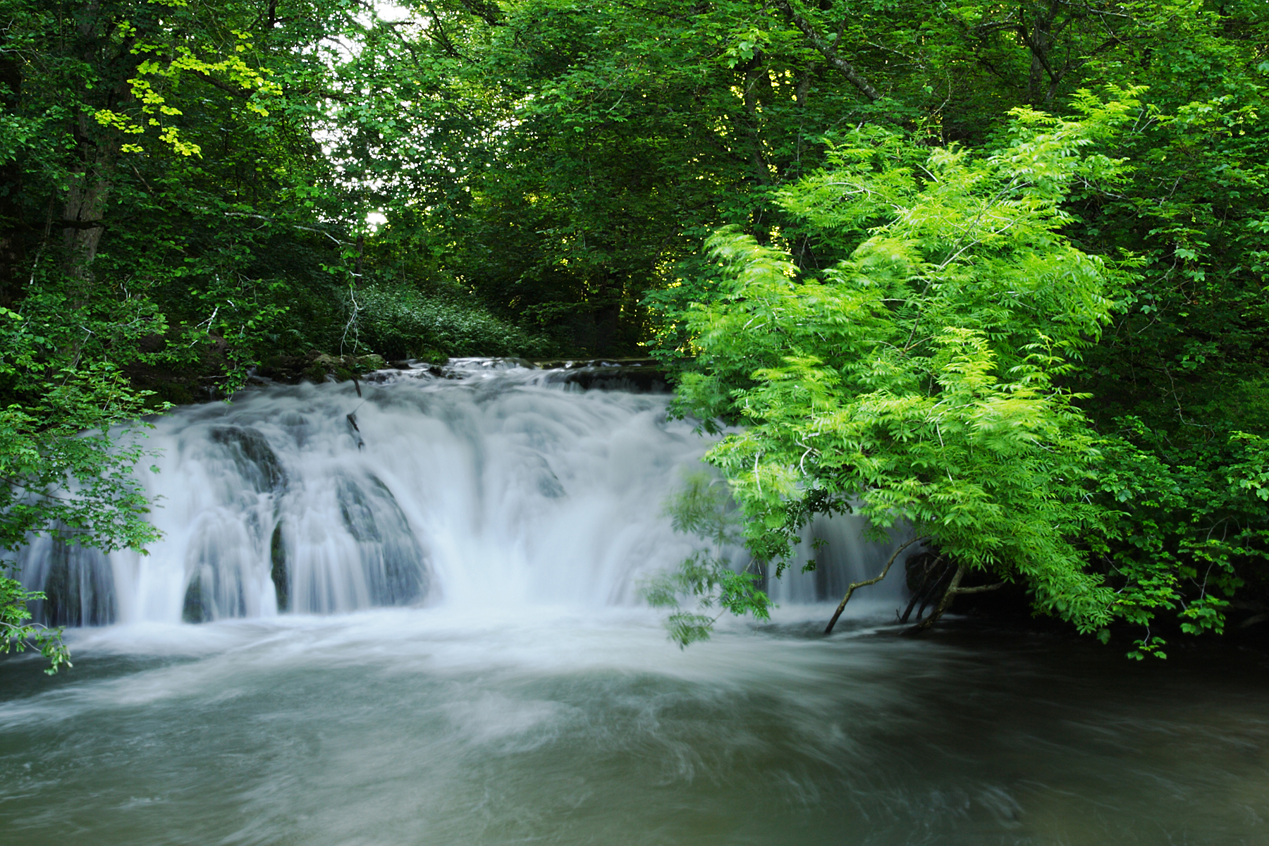
Deutsch: Einer von mehreren Wasserfallstufen an der Unteren Großen Lauter, 3 km nach Anhausen, Schwäbische Alb. Seit dem frühen Holozän ist über ca. 2 km im Wasser gelöstes Calciumcarbonat chemisch ausgefällt und als Kalktuff sedimentiert worden. Im Bild ist die 4 m hohe, noch in ihrem natürlichen Zustand erhaltene, Stufe sichtbar. Vor und hinter dieser Stufe haben sich im Lauter-Bett noch ca. 30 cm hohe, kleine Stufen gebildet. Nach H. Prinz (1959), Geologe, handelt es sich hier „weniger um einen Wasserfall, als um mehrere große kaskadenförmige Stromschnellen“. Es sei auch „sehr auffallend“, dass „sprunghafte Änderungen des Gefälles“ der Großen Lauter, wie an diesem Segment „immer mit Sinterkalkbildung (author: Kalktuff) verbunden sind“ . Das Gefälle erhöht sich noch ein weiteres mal sprunghaft vor der „Laufenmühle“ (vor Lauterach). Auch dort kam es noch einmal zu großer Kalktuffansammlung und zu einem Wasserfall. Andere Ursachen als turbulentes Wasser durch größeres Gefälle gelten als noch ungeklärt. English: Water fall at the lower “Große Lauter”. The river’s picturesque karst spring in “Offenhausen” (Gomaringen) and the green, picturesque valley meandering 44 km through the karstic Swabian Alb are a great attraction, worldwide. Its water carries lots of soluted calcium carbonate, which is chemically precipitated and sedimented as calcareous tuff, whenever the drop of the river increases suddenly. That is the case 3 km after the village “Anhausen”, as the geologist H. Prinz stated. At the “Laufenmühle” (near “Lauterach”) the drop of the river increases again suddenly. There, the relatively wide valley’s calcareous tuff has already been totally exploited in several large quarries. Other causes beside turbulent water are scientifically insufficiently backed. |
||||
| Date | |||||
| Source | Own work | ||||
| Author | Ustill | ||||
| references |
|


Licensing
[edit]
This file is licensed under the Creative Commons Attribution-Share Alike 3.0 Germany license.
- You are free:
- to share – to copy, distribute and transmit the work
- to remix – to adapt the work
- Under the following conditions:
- attribution – You must give appropriate credit, provide a link to the license, and indicate if changes were made. You may do so in any reasonable manner, but not in any way that suggests the licensor endorses you or your use.
- share alike – If you remix, transform, or build upon the material, you must distribute your contributions under the same or compatible license as the original.

File history
Click on a date/time to view the file as it appeared at that time.
| Date/Time | Thumbnail | Dimensions | User | Comment | |
|---|---|---|---|---|---|
| current | 12:22, 10 August 2016 | | 1,800 × 1,200 (2.15 MB) | Ustill (talk | contribs) | User created page with UploadWizard |
You cannot overwrite this file.
File usage on Commons
There are no pages that use this file.
File usage on other wikis
The following other wikis use this file:
- Usage on de.wikipedia.org
- Usage on www.wikidata.org